Orkdal
| Orkdal kommune | |||
|---|---|---|---|
| Municipality | |||
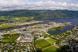 View of Orkanger | |||
| |||
 Orkdal within Trøndelag | |||
| Coordinates: 63°17′20″N 09°43′34″E / 63.28889°N 9.72611°ECoordinates: 63°17′20″N 09°43′34″E / 63.28889°N 9.72611°E | |||
| Country | Norway | ||
| County | Trøndelag | ||
| District | Orkdalen | ||
| Established | 1 Jan 1838 | ||
| Administrative centre | Orkanger | ||
| Government | |||
| • Mayor (2015) | Oddbjørn Bang (Sp) | ||
| Area | |||
| • Total | 594.32 km2 (229.47 sq mi) | ||
| • Land | 564.27 km2 (217.87 sq mi) | ||
| • Water | 30.05 km2 (11.60 sq mi) 5% | ||
| Area rank | #188 in Norway | ||
| Population (2017) | |||
| • Total | 11,891 | ||
| • Rank | #98 in Norway | ||
| • Density | 21.1/km2 (55/sq mi) | ||
| • Change (10 years) | 10.0% | ||
| Demonym(s) | Orkdaling[1] | ||
| Time zone | UTC+01:00 (CET) | ||
| • Summer (DST) | UTC+02:00 (CEST) | ||
| ISO 3166 code | NO-5024 | ||
| Official language form | Neutral | ||
| Website |
orkdal | ||


Orkdal is a municipality in Trøndelag county, Norway. It is part of the Orkdalen region. The administrative centre of the municipality is the city of Orkanger. Some of the notable villages in the municipality include Kjøra, Geitastrand, Gjølme, Thamshavn, Fannrem, Vormstad, Svorkmo, and Hoston.
Agriculture plays a significant role in the municipality. The Thamshavnbanen was used to transport ore from Løkken Verk to the port of Thamshavn, and is now a vintage railway. The Fannrem concentration camp was located in Fannrem during World War II. Orkanger is one of the main industrial hubs in central Norway. The industry is mainly located around Grønøra Industrial park. The largest companies are Technip Offshore Norge AS, Reinertsen, Washington Mills and Elkem Thamshavn AS.
The 594-square-kilometre (229 sq mi) municipality is the 188th largest by area out of the 422 municipalities in Norway. Orkdal is the 98th most populous municipality in Norway with a population of 11,891. The municipality's population density is 21.1 inhabitants per square kilometre (55/sq mi) and its population has increased by 10% over the last decade.[2]
General information
The prestegjeld of Orkdal was established as a municipality on 1 January 1838 (see formannskapsdistrikt). On 1 July 1920, the port of Orkanger (population: 1,715) and the southern district of Orkland (population: 1,760) were separated from Orkdal to form separate municipalities. During the 1960s, there were many municipal mergers across Norway due to the work of the Schei Committee. On 1 January 1963, the municipalities of Orkanger, Orkland, and Geitastrand were merged with Orkdal to form a new, larger municipality of Orkdal.[3]
On 1 January 2018, the municipality switched from the old Sør-Trøndelag county to the new Trøndelag county.
On 1 January 2020, the municipalities of Agdenes, Orkdal, and Meldal along with the majority of Snillfjord will be merged to form the new municipality of Orkland.[4]
Name
The Old Norse form of the name was Orkardalr. The first element is the genitive case of the name of the river Ork (now Orklaelva) and the last element is dalr which means "valley" or "dale". Historically, the name was spelled Orkedalen.[5]
Coat of arms
The coat of arms is from modern times. They were granted on 25 April 1986. They show a silver line on a green background, representing the Orklaelva which runs through fertile Orkdalen valley throughout the municipality. It is also a canting because the name of the municipality is derived from the name of the river.[6]
Churches
The Church of Norway has four parishes (sokn) within the municipality of Orkdal. It is part of the Orkdal prosti (deanery) in the diocese of Nidaros.
| Parish (Sokn) | Church Name | Location of the Church | Year Built |
|---|---|---|---|
| Geitastrand | Geitastrand Church | Geitastrand | 1859 |
| Orkanger | Orkanger Church | Orkanger | 1892 |
| Orkdal | Orkdal Church | Fannrem | 1893 |
| Søvasskjølen Church | Svorksjødalen | 1981 | |
| Orkland | Moe Church | Vormstad | 1867 |
Government
All municipalities in Norway, including Orkdal, are responsible for primary education (through 10th grade), outpatient health services, senior citizen services, unemployment and other social services, zoning, economic development, and municipal roads. The municipality is governed by a municipal council of elected representatives, which in turn elect a mayor. The municipality falls under the Sør-Trøndelag District Court and the Frostating Court of Appeal.
Municipal council
The municipal council (Kommunestyre) of Orkdal is made up of 35 representatives that are elected to four year terms. Currently, the party breakdown is as follows:[7]
| Party Name | Name in Norwegian | Number of representatives | |
|---|---|---|---|
| Labour Party | Arbeiderpartiet | 10 | |
| Progress Party | Fremskrittspartiet | 1 | |
| Conservative Party | Høyre | 2 | |
| Christian Democratic Party | Kristelig Folkeparti | 1 | |
| Pensioners' Party | Pensjonistpartiet | 2 | |
| Centre Party | Senterpartiet | 7 | |
| Socialist Left Party | Sosialistisk Venstreparti | 1 | |
| Liberal Party | Venstre | 2 | |
| Local Lists | Lokale lister | 9 | |
| Total number of members: | 35 | ||
Geography
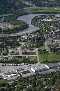
A large part of the population is concentrated in the Orkanger/Fannrem area, which is situated at the head of the Orkdalsfjord, a branch of the large Trondheimsfjord. The Orkla River, one of the better salmon rivers in Norway, meets the sea at Orkanger.
The lakes Hostovatnet, Gangåsvatnet, Våvatnet and Svorksjøen are lakes located around the municipality.
The municipalities of Agdenes, Snillfjord and Hemne lie to the northwest, Rindal (in Møre og Romsdal) and Meldal to the south, and Melhus and Skaun to the east, and Trondheim and Indre Fosen lie to the northeast across the Trondheimsfjord.
Notable residents
- Johan Bojer, author
- Nils Arne Eggen, the former coach of Rosenborg BK
- Roar Ljøkelsøy, ski jumper
- Gunnhild Sundli, singer of the Norwegian folk music band Gåte
- Sveinung Sundli, fiddle and keyboard player of Gåte
International relations
Twin towns – Sister cities
Orkdal is twinned with:
References
- ↑ "Navn på steder og personer: Innbyggjarnamn" (in Norwegian). Språkrådet. Retrieved 2015-12-01.
- ↑ Statistisk sentralbyrå (2017). "Table: 06913: Population 1 January and population changes during the calendar year (M)" (in Norwegian). Retrieved 2017-10-08.
- ↑ Jukvam, Dag (1999). "Historisk oversikt over endringer i kommune- og fylkesinndelingen" (PDF) (in Norwegian). Statistisk sentralbyrå.
- ↑ "Nye Orkland: Kommunene" (in Norwegian). Retrieved 2017-10-08.
- ↑ Rygh, Oluf (1901). Norske gaardnavne: Søndre Trondhjems amt (in Norwegian) (14 ed.). Kristiania, Norge: W. C. Fabritius & sønners bogtrikkeri. p. 125.
- ↑ Norske Kommunevåpen (1990). "Nye kommunevåbener i Norden". Retrieved 27 October 2008.
- ↑ "Table: 04813: Members of the local councils, by party/electoral list at the Municipal Council election (M)" (in Norwegian). Statistics Norway. 2015.
- ↑ "Mostar Gradovi prijatelji" [Mostar Twin Towns]. Grad Mostar [Mostar Official City Website] (in Macedonian). Archived from the original on 2013-10-30. Retrieved 2013-12-19.
External links
| Wikimedia Commons has media related to Orkdal. |

- Municipal fact sheet from Statistics Norway (in Norwegian)
| |||||||
| |||||||
| |||||||

| Authority control |
|---|