Melhus
| Melhus kommune | |||
|---|---|---|---|
| Municipality | |||
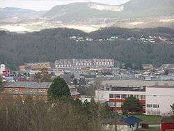 View of Melhus sentrum | |||
| |||
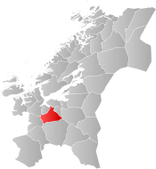 Melhus within Trøndelag | |||
| Coordinates: 63°10′35″N 10°18′13″E / 63.17639°N 10.30361°ECoordinates: 63°10′35″N 10°18′13″E / 63.17639°N 10.30361°E | |||
| Country | Norway | ||
| County | Trøndelag | ||
| District | Gauldalen | ||
| Established | 1 Jan 1838 | ||
| Administrative centre | Melhus | ||
| Government | |||
| • Mayor (2015) | Gunnar Krogstad (Ap) | ||
| Area | |||
| • Total | 694.40 km2 (268.11 sq mi) | ||
| • Land | 653.79 km2 (252.43 sq mi) | ||
| • Water | 40.61 km2 (15.68 sq mi) 5.8% | ||
| Area rank | #162 in Norway | ||
| Population (2017) | |||
| • Total | 16,213 | ||
| • Rank | #71 in Norway | ||
| • Density | 24.8/km2 (64/sq mi) | ||
| • Change (10 years) | 13.3% | ||
| Demonym(s) | Melhusbygg[1] | ||
| Time zone | UTC+01:00 (CET) | ||
| • Summer (DST) | UTC+02:00 (CEST) | ||
| ISO 3166 code | NO-5028 | ||
| Official language form | Neutral | ||
| Website |
melhus | ||

Melhus is a municipality in Trøndelag county, Norway. It is part of the Gauldalen region. The administrative centre of the municipality is the village of Melhus. Other villages include Gåsbakken, Hovin, Korsvegen, Kvål, Ler, Lundamo, Storsand, and Øysand.
Agriculture is important in Melhus, and the extensive lowland areas in the almost flat valley surrounding the Gaula River are dominated by grain fields. Many inhabitants work in the city of Trondheim, a 20-minute drive north from Melhus.
The 694-square-kilometre (268 sq mi) municipality is the 162nd largest by area out of the 422 municipalities in Norway. Melhus is the 71st most populous municipality in Norway with a population of 16,213. The municipality's population density is 24.8 inhabitants per square kilometre (64/sq mi) and its population has increased by 13.3% over the last decade.[2]
General information
Melhus was established as a municipality on 1 January 1838 (see formannskapsdistrikt). In 1865, the western district of Høilandet (population: 1,818) was separated from Melhus to form a separate municipality. Then on 1880, the eastern district of Flå (population: 614) was separated to form its own municipality. On 1 January 1964, Melhus (population: 3,978) was merged with the neighboring municipalities of Hølonda (population: 1,428), Flå (population: 843), Horg (population: 2,560), and the small Langørgen farm area in Buvik (population: 11) to form a new, larger municipality of Melhus.[3] On 1 January 2018, the municipality switched from the old Nord-Trøndelag county to the new Trøndelag county.
Name
The municipality (originally the parish) is named after the old Melhus farm (Old Norse: Meðalhúsar), since the first Melhus Church was built there. The first element is meðal which means "middle" and the last element is the plural form of hús which means "house". The farm is one part of a greater and older farm, which had the name Óðinssalr which means "the salr (mead hall) of Odin".[4]
Coat of arms
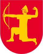
The coat of arms is from modern times; they were granted on 8 November 1979. The arms show a gold-colored archer with a red background. The arms were chosen to symbolize Einar Tambarskjelve, who was a famous chief and archer from Melhus in the 11th century. He is mentioned as an archer for King Olav Tryggvason in the Battle of Svolder.[5]
Churches
The Church of Norway has four parishes (sokn) within the municipality of Melhus. It is part of the Gauldal prosti (deanery) in the Diocese of Nidaros.
| Parish (Sokn) | Church Name | Location of the Church | Year Built |
|---|---|---|---|
| Flå | Flå Church | Ler | 1794 |
| Horg | Horg Church | Lundamo | 1892 |
| Hølonda | Hølonda Church | Gåsbakken | 1848 |
| Melhus | Melhus Church | Storsand | 1892 |
History
Melhus was the site of many important events during the Viking Era. It was the site of the farm Rimul in Melhus at which Jarl Haakon was killed by his slave, Tormod Kark. Jarlshola is the location in Melhus thought to have been the hiding place of Jarl Haakon and Tormod Kark on their last night before the infamous murder at Rimul.
Geography

The 695-square-kilometre (268 sq mi) municipality of Melhus includes the valley of the river Gaula as it flows northwards towards its mouth at the Gaulosen, an arm of the Trondheimsfjord. The lake Svorksjøen lies on the western border with Orkdal and Meldal. The lakes Benna and Ånøya lie in the central part of the municipality, and the lake Samsjøen lies on the southeastern border with Midtre Gauldal municipality. The mountains of Rensfjellet and Vassfjellet lie on the eastern border with Selbu and Klæbu municipalities, respectively.
Government
All municipalities in Norway, including Melhus, are responsible for primary education (through 10th grade), outpatient health services, senior citizen services, unemployment and other social services, zoning, economic development, and municipal roads. The municipality is governed by a municipal council of elected representatives, which in turn elect a mayor. The municipality falls under the Sør-Trøndelag District Court and the Frostating Court of Appeal.
Municipal council
The municipal council (Kommunestyre) of Melhus is made up of 37 representatives that are elected to four year terms. Currently, the party breakdown is as follows:[6]
| Party Name | Name in Norwegian | Number of representatives | |
|---|---|---|---|
| Labour Party | Arbeiderpartiet | 14 | |
| Progress Party | Fremskrittspartiet | 2 | |
| Conservative Party | Høyre | 5 | |
| Christian Democratic Party | Kristelig Folkeparti | 2 | |
| Green Party | Miljøpartiet De Grønne | 1 | |
| Centre Party | Senterpartiet | 7 | |
| Socialist Left Party | Sosialistisk Venstreparti | 1 | |
| Liberal Party | Venstre | 1 | |
| Local Lists | Lokale lister | 4 | |
| Total number of members: | 37 | ||
Transportation
European route E6 runs north and south through the municipality, following the Gaula River. There is also a 3-kilometre (1.9 mi) long stretch of European route E39 passes east and west in the northern part of Melhus between Buvika and Leinstrand.
The Dovre Line also follows the river through Melhus. The following stations are located along the railway line in Melhus: Melhus Station, Kvål Station, Ler Station, Lundamo Station, and Hovin Station. The railroad goes through the Gulfoss Tunnel at Hovin.
Gallery

.jpg)


Newspapers
- Trønderbladet: Largest newspaper in Melhus.
- Gaula: Newspaper published in Melhus which also covers the Midtre Gauldal and Byneset
Notable residents
- Einar Thambarskelfir (c. 980 – c. 1050) - Influential nobleman and politician, de facto ruler of Norway
- Johannes Klingenberg Sejersted (1761–1823) - General and head of the General Staff
- Hartvig Nissen (1815–1874) - Philologist and educator
- Walter Scott Dahl (1839–1906) - Government minister and MP for the Liberal Party
- Martin Tranmæl (1879–1967) - Party Secretary and MP for the Norwegian Labour Party, editor of Arbeiderbladet
- Per Borten (1913–2005) - Prime Minister, and MP for the Centre Party
- Odd Bye (1916–2010) - Newspaperman and State Secretary for the Centre Party
- Magnar Estenstad (1924–2004) - Cross-country skier
- Toralf Engan (b. 1939) - World and Olympic champion ski jumper
- Hans Flock (b. 1940) - Supreme Court Justice
- Kjell Helland (b. 1940) - MP for the Norwegian Labour Party
- Magne Thomassen (b. 1941) - Speed skater
- Tor Singsaas (b. 1948) - Bishop of Nidaros
- Oddvar Brå (b. 1951) - World champion cross-country skier
- Torstein Flakne (b. 1960) - Rock musician, member of The Kids and founder of Stage Dolls
- Unni Lehn (b. 1977) - Olympic champion footballer
References
- ↑ "Navn på steder og personer: Innbyggjarnamn" (in Norwegian). Språkrådet. Retrieved 2015-12-01.
- ↑ Statistisk sentralbyrå (2017). "Table: 06913: Population 1 January and population changes during the calendar year (M)" (in Norwegian). Retrieved 2017-10-08.
- ↑ Jukvam, Dag (1999). "Historisk oversikt over endringer i kommune- og fylkesinndelingen" (PDF) (in Norwegian). Statistisk sentralbyrå.
- ↑ Rygh, Oluf (1901). Norske gaardnavne: Søndre Trondhjems amt (in Norwegian) (14 ed.). Kristiania, Norge: W. C. Fabritius & sønners bogtrikkeri. p. 286.
- ↑ Norske Kommunevåpen (1990). "Nye kommunevåbener i Norden". Retrieved 26 October 2008.
- ↑ "Table: 04813: Members of the local councils, by party/electoral list at the Municipal Council election (M)" (in Norwegian). Statistics Norway. 2015.
External links
| Wikimedia Commons has media related to Melhus. |

- Municipal fact sheet from Statistics Norway (in Norwegian)
- Municipal website (in Norwegian)
- Melhus Prestegårdslåna (in Norwegian)
- Local history of Melhus (in Norwegian)
| |||||||
| |||||||
| |||||||

| Authority control |
|---|