Meldal
| Meldal kommune | |||
|---|---|---|---|
| Municipality | |||
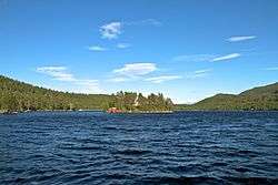 View of the lake Frilsjøen | |||
| |||
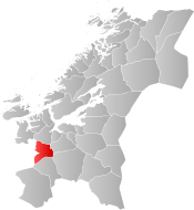 Meldal within Trøndelag | |||
| Coordinates: 63°03′04″N 09°44′14″E / 63.05111°N 9.73722°ECoordinates: 63°03′04″N 09°44′14″E / 63.05111°N 9.73722°E | |||
| Country | Norway | ||
| County | Trøndelag | ||
| District | Orkdalen | ||
| Established | 1 Jan 1838 | ||
| Administrative centre | Meldal | ||
| Government | |||
| • Mayor (2011) | Are Hilstad (Sp) | ||
| Area | |||
| • Total | 613.34 km2 (236.81 sq mi) | ||
| • Land | 592.59 km2 (228.80 sq mi) | ||
| • Water | 20.75 km2 (8.01 sq mi) 3.4% | ||
| Area rank | #184 in Norway | ||
| Population (2017) | |||
| • Total | 3,960 | ||
| • Rank | #233 in Norway | ||
| • Density | 6.7/km2 (17/sq mi) | ||
| • Change (10 years) | 1.5% | ||
| Demonym(s) | Meldaling[1] | ||
| Time zone | UTC+01:00 (CET) | ||
| • Summer (DST) | UTC+02:00 (CEST) | ||
| ISO 3166 code | NO-5023 | ||
| Official language form | Neutral | ||
| Website |
meldal | ||

Meldal is a municipality in Trøndelag county, Norway. It is part of the Orkdalen region. The administrative centre of the municipality is the village of Meldal. Other villages include Løkken Verk, Bjørnli, Å, and Storås.
The municipality is most renowned for its mining activities at Løkken Verk, being the birthplace of the Orkla mining company, now Orkla Group. It is also home to the annual Storåsfestivalen music festival.
The 613-square-kilometre (237 sq mi) municipality is the 184th largest by area out of the 422 municipalities in Norway. Meldal is the 233rd most populous municipality in Norway with a population of 3,960. The municipality's population density is 6.7 inhabitants per square kilometre (17/sq mi) and its population has increased by 1.5% over the last decade.[2]
General information

Meldal was established as a municipality on 1 January 1838 (see formannskapsdistrikt). In 1839, the southern district of Rennebu was separated from Meldal to form a municipality of its own.[3]
On 1 January 2018, the municipality switched from the old Sør-Trøndelag county to the new Trøndelag county.
On 1 January 2020, the municipalities of Agdenes, Orkdal, and Meldal along with the majority of Snillfjord will be merged to form the new municipality of Orkland.[4]
Name
The Old Norse form of the name was Meðaldalr. The first element is meðal which means "middle" and the last element is dalr which means "valley" or "dale". The municipality is named this probably because it is located in the middle of the Orkdalen valley. The name was historically spelled Meldalen.[5]
Coat of arms
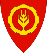
The coat of arms is from modern times. They were granted on 5 February 1985. The arms are a combination of a wheel as a symbol for the local industry, and a wheat ear as a symbol for the agriculture. Both items are yellow on a red background.[6]
Churches
The Church of Norway has two parishes (sokn) within the municipality of Meldal. It is part of the Gauldal prosti (deanery) in the Diocese of Nidaros.
| Parish (Sokn) | Church Name | Location of the Church | Year Built |
|---|---|---|---|
| Løkken | Løkken Church | Bjørnli | 1929 |
| Meldal | Meldal Church | Meldal | 1988 |
Government
All municipalities in Norway, including Meldal, are responsible for primary education (through 10th grade), outpatient health services, senior citizen services, unemployment and other social services, zoning, economic development, and municipal roads. The municipality is governed by a municipal council of elected representatives, which in turn elect a mayor. The municipality falls under the Sør-Trøndelag District Court and the Frostating Court of Appeal.
Municipal council
The municipal council (Kommunestyre) of Meldal is made up of 19 representatives that are elected to four year terms. Currently, the party breakdown is as follows:[7]
| Party Name | Name in Norwegian | Number of representatives | |
|---|---|---|---|
| Labour Party | Arbeiderpartiet | 10 | |
| Progress Party | Fremskrittspartiet | 1 | |
| Conservative Party | Høyre | 1 | |
| Centre Party | Senterpartiet | 5 | |
| Local Lists | Lokale lister | 2 | |
| Total number of members: | 19 | ||
Geography
The municipality of Meldal is located along the Orkla River in the middle of the Orkdalen valley. The lakes Hostovatnet and Svorksjøen are located along the northern border of the municipality.
The municipality of Rindal (in Møre og Romsdal) lies to the west, Rennebu lies to the south, Midtre Gauldal and Melhus to the east, and Orkdal to the north.
The Løkken Station was the terminal station on the historic Thamshavn Line railway that used to travel through the municipality.
References
- ↑ "Navn på steder og personer: Innbyggjarnamn" (in Norwegian). Språkrådet. Retrieved 2015-12-01.
- ↑ Statistisk sentralbyrå (2017). "Table: 06913: Population 1 January and population changes during the calendar year (M)" (in Norwegian). Retrieved 2017-10-08.
- ↑ Jukvam, Dag (1999). "Historisk oversikt over endringer i kommune- og fylkesinndelingen" (PDF) (in Norwegian). Statistisk sentralbyrå.
- ↑ "Nye Orkland: Kommunene" (in Norwegian). Retrieved 2017-10-08.
- ↑ Rygh, Oluf (1901). Norske gaardnavne: Søndre Trondhjems amt (in Norwegian) (14 ed.). Kristiania, Norge: W. C. Fabritius & sønners bogtrikkeri. p. 149.
- ↑ Norske Kommunevåpen (1990). "Nye kommunevåbener i Norden". Retrieved 26 October 2008.
- ↑ "Table: 04813: Members of the local councils, by party/electoral list at the Municipal Council election (M)" (in Norwegian). Statistics Norway. 2015.
External links
| Wikimedia Commons has media related to Meldal. |

- Municipal fact sheet from Statistics Norway (in Norwegian)
| |||||||
| |||||||
| |||||||

| Authority control |
|---|