Røyrvik
| Røyrvik kommune Raarvihken tjïelte | |||
|---|---|---|---|
| Municipality | |||
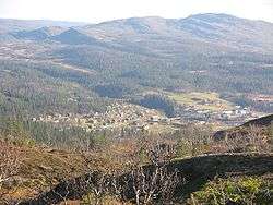 View of the village of Røyrvik | |||
| |||
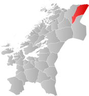 Røyrvik within Trøndelag | |||
| Coordinates: 64°55′15″N 13°39′03″E / 64.92083°N 13.65083°ECoordinates: 64°55′15″N 13°39′03″E / 64.92083°N 13.65083°E | |||
| Country | Norway | ||
| County | Trøndelag | ||
| District | Namdalen | ||
| Established | 1 July 1923 | ||
| Administrative centre | Røyrvik | ||
| Government | |||
| • Mayor (2015) | Hans Oskar Devik (Sp) | ||
| Area | |||
| • Total | 1,584.76 km2 (611.88 sq mi) | ||
| • Land | 1,332.39 km2 (514.44 sq mi) | ||
| • Water | 252.37 km2 (97.44 sq mi) 15.9% | ||
| Area rank | #44 in Norway | ||
| Population (2017) | |||
| • Total | 469 | ||
| • Rank | #419 in Norway | ||
| • Density | 0.4/km2 (1/sq mi) | ||
| • Change (10 years) | -10.8% | ||
| Time zone | UTC+01:00 (CET) | ||
| • Summer (DST) | UTC+02:00 (CEST) | ||
| ISO 3166 code | NO-5043 | ||
| Official language form | Neutral | ||
| Website |
royrvik | ||


Røyrvik (Norwegian) or Raarvihke (Southern Sami) is a municipality in Trøndelag county, Norway. It is part of the Namdalen region. The administrative centre of the municipality is the village of Røyrvik. The area has always had a strong Sami influence.
The 1,585-square-kilometre (612 sq mi) municipality is the 44th largest by area out of the 422 municipalities in Norway. Røyrvik is the 419th most populous municipality in Norway with a population of 469 making it the 4th smallest population in Norway. The municipality's population density is 0.4 inhabitants per square kilometre (1.0/sq mi) and its population has decreased by 10.8% over the last decade.[1]
General information
The municipality of Røyrvik was established on 1 July 1923 when it was separated from the municipality of Grong. Initially, the population was 392. The municipal boundaries have not since changed.[2] On 1 January 2018, the municipality switched from the old Nord-Trøndelag county to the new Trøndelag county.
Name
The municipality (originally the parish) is named after the old Røyrvik farm (historically: Røirviken), since the first church, Røyrvik Church, was built there (in 1828). The first element is røyr which means Arctic char and the last element is vik which means "inlet".[3]
Coat of arms
The coat of arms is from modern times; they were granted on 13 December 1985. The arms show a silver cross design on a blue background. This design is a common decoration on the pottery, hand-made articles, and traditional pewter embroidery found in the area. These objects were made by the ancestors of the Southern Sámi people presently living in the area. The crosses probably indicate the four points of the compass.[4]
Churches
The Church of Norway has one parish (sokn) within the municipality of Røyrvik. It is part of the Namdal prosti (deanery) in the Diocese of Nidaros.
| Parish (Sokn) | Church Name | Location of the Church | Year Built |
|---|---|---|---|
| Røyrvik | Røyrvik Church | Røyrvik | 1828 |
Geography
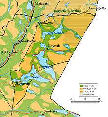
The area is covered with many large lakes such as Limingen, the 9th largest in Norway. Other lakes include Jengelvatnet, Namsvatnet, Ovrejaevrie, Storgollomsvatnet, Tunnsjøen, and Tunnsjøflyan. The river Namsen begins in the lake Namsvatnet.
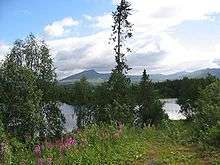
The mountainous areas also offer plentiful opportunities for outdoor activities. The highest mountain is the 1,513-metre (4,964 ft) tall Jetnamsklumpen, located inside Børgefjell National Park.
Government
All municipalities in Norway, including Røyrvik, are responsible for primary education (through 10th grade), outpatient health services, senior citizen services, unemployment and other social services, zoning, economic development, and municipal roads. The municipality is governed by a municipal council of elected representatives, which in turn elect a mayor. The municipality falls under the Namdal District Court and the Frostating Court of Appeal.
Municipal council
The municipal council (Kommunestyre) of Røyrvik is made up of 13 representatives that are elected to four year terms. Currently, the party breakdown is as follows:[5]
| Party Name | Name in Norwegian | Number of representatives | |
|---|---|---|---|
| Labour Party | Arbeiderpartiet | 4 | |
| Local Lists | Lokale lister | 9 | |
| Total number of members: | 13 | ||
Economy
From 1911 until World War I, mining explorations were conducted in the Gjersvik areas. The modern Grong Gruber mines were active in the Joma area from 1972 until 1998. Farming and reindeer husbandry have always been a source of income in the area. The mining buildings now house various small industrial firms.
A few efforts to create new business include electronics assembly and electronic document management. A small alpine ski resort (Skisenteret) was started in 1986.
References
- ↑ Statistisk sentralbyrå (2017). "Table: 06913: Population 1 January and population changes during the calendar year (M)" (in Norwegian). Retrieved 2017-10-01.
- ↑ Jukvam, Dag (1999). "Historisk oversikt over endringer i kommune- og fylkesinndelingen" (PDF) (in Norwegian). Statistisk sentralbyrå.
- ↑ Rygh, Oluf (1903). Norske gaardnavne: Nordre Trondhjems amt (dokpro.uio.no) (in Norwegian) (15 ed.). Kristiania, Norge: W. C. Fabritius & sønners bogtrikkeri. p. 299.
- ↑ "Civic heraldry of Norway - Norske Kommunevåpen". Heraldry of the World. Retrieved 2018-04-26.
- ↑ "Table: 04813: Members of the local councils, by party/electoral list at the Municipal Council election (M)" (in Norwegian). Statistics Norway. 2015.
External links
| Wikimedia Commons has media related to Røyrvik. |

- Municipal fact sheet from Statistics Norway (in Norwegian)
| |||||||
| |||||||
| |||||||
