Inderøy
| Inderøy kommune | |||
|---|---|---|---|
| Municipality | |||
 | |||
| |||
 Inderøy within Trøndelag | |||
| Coordinates: 63°53′58″N 11°13′12″E / 63.89944°N 11.22000°ECoordinates: 63°53′58″N 11°13′12″E / 63.89944°N 11.22000°E | |||
| Country | Norway | ||
| County | Trøndelag | ||
| District | Innherad | ||
| Established | 1 Jan 1838 | ||
| Administrative centre | Straumen | ||
| Government | |||
| • Mayor (2011) | Ida Stuberg (Sp) | ||
| Area | |||
| • Total | 365.67 km2 (141.19 sq mi) | ||
| • Land | 351.14 km2 (135.58 sq mi) | ||
| • Water | 14.53 km2 (5.61 sq mi) 4% | ||
| Area rank | #253 in Norway | ||
| Population (2017) | |||
| • Total | 6,800 | ||
| • Rank | #153 in Norway | ||
| • Density | 19.4/km2 (50/sq mi) | ||
| • Change (10 years) | 0.1% | ||
| Demonym(s) | Inderøyning[1] | ||
| Time zone | UTC+01:00 (CET) | ||
| • Summer (DST) | UTC+02:00 (CEST) | ||
| ISO 3166 code | NO-5053 | ||
| Official language form | Neutral | ||
| Website |
inderoy | ||

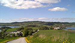
Inderøy is a municipality in Trøndelag county, Norway. It is part of the Innherad region. The administrative centre of the municipality is the village of Straumen. Other villages include Framverran, Gangstadhaugen, Hylla, Kjerknesvågen, Kjerringvik, Røra, Sakshaug, Sandvollan, Småland, Trongsundet, Utøy, Vangshylla, and Venneshamn. The municipality is primarily an agricultural community, but also has some industry.
The 366-square-kilometre (141 sq mi) municipality is the 253rd largest by area out of the 422 municipalities in Norway. Inderøy is the 153rd most populous municipality in Norway with a population of 6,800. The municipality's population density is 19.4 inhabitants per square kilometre (50/sq mi) and its population has increased by 0.1% over the last decade.[2]
General information
Inderøy was established as a municipality on 1 January 1838 (see formannskapsdistrikt). On 1 January 1907, the municipality was divided into three municipalities: Røra (population: 866) in the southeast, Hustad (population: 732) in the north, and Inderøy (population: 2,976) in the west. During the 1960s, there were many municipal mergers across Norway due to the work of the Schei Committee. On 1 January 1962, the three neighboring municipalities of Røra (population: 1,003), Sandvollan (population: 750), and Inderøy (population: 3,194) to form a new, larger municipality of Inderøy.[3] On 1 January 2012, the neighboring municipality of Mosvik was merged into Inderøy. This added about 800 more residents to the municipality, bringing the total population to 6,716 people. On 1 January 2018, the municipality switched from the old Nord-Trøndelag county to the new Trøndelag county.
Name
The municipality is named Inderøy (historically spelled Inderøen) which comes from the Old Norse form of the name: Eynni iðri, meaning is "the inner island", probably referring to the Inderøya peninsula which sticks out into the fjord. Neighboring Ytterøy, meaning "the outer island", is similarly named.[4]
Coat of arms
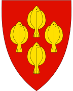
The coat of arms is from modern times; they were granted on 5 October 1984. The arms show four gold-colored European plaice (a type of flat fish) on a red background. This fish was once plentiful and was one of the main sources of income for the area until around 1940.[5] The arms were re-approved after the Inderøy-Mosvik merger in 2012. The old arms of Inderøy were continued since fishing is still important to the culture and history of the new municipality. The four fish shown on the arms now represent the four original municipalities that now make up Inderøy: Inderøy, Mosvik, Røra, and Sandvollan.[6]
Churches
The Church of Norway has four parishes (sokn) within the municipality of Inderøy. It is part of the Nord-Innherad prosti (deanery) in the Diocese of Nidaros.
| Parish (Sokn) | Church Name | Location of the Church | Year Built |
|---|---|---|---|
| Inderøy | Sakshaug Church | Straumen | 1871 |
| Sakshaug gamle Church | Sakshaug | c. 1150 | |
| Røra | Salberg Church | Røra | 1715 |
| Sandvollan | Heggstad Church | Sandvollan | 1887 |
| Hustad Church | Gangstad | c. 1150 | |
| Mosvik | Mosvik Church | Mosvik | 1884 |
| Vestvik Church | Framverran | 1905 |
History

During the Middle Ages Inderøy was called Eynni iðri, meaning the inner island, which is still the meaning of the word Inderøy. Saurshaug (now Sakshaug) was an important political centre until the 20th century. In the Middle Ages it was the centre of the county Øynafylket, also including Beitstad and Verran. The Sakshaug Old Church was opened by Archbishop Eysteinn Erlendsson in 1184 and was the county church. Many of the construction techniques used in the archbishop's cathedral Nidarosdomen in Trondheim were experimented with on Sakshaug Old Church. Also the village of Sandvollan has a church from the Middle Ages, Hustad Church.
During the late Middle Ages and until the breakup of the union between Sweden and Norway Inderøy was the seat of the Governor, Judge, and Tax Collector of Nordre Trondhjems amt, thus it was the county capital of the old Nord-Trøndelag county. The district court for the north central part of Trøndelag county is still named after Inderøy.
Government

All municipalities in Norway, including Inderøy, are responsible for primary education (through 10th grade), outpatient health services, senior citizen services, unemployment and other social services, zoning, economic development, and municipal roads. The municipality is governed by a municipal council of elected representatives, which in turn elect a mayor.
The administrative centre of Inderøy is Straumen where most of the commercial services are based. Municipal services are located about 1 kilometre (0.62 mi) to the north, at Sakshaug. There are several boroughs in Inderøy: Kjerknesvågen, Mosvik, Røra, Sandvollan, Sakshaug, and Utøy. Each has its own primary school and community centre.
Inderøy is part of the Diocese of Nidaros, Inderøy District Court, and Frostating Court of Appeal.
Municipal council
The municipal council (Kommunestyre) of Inderøy is made up of 31 representatives that are elected to four year terms. Currently, the party breakdown is as follows:[7]
| Party Name | Name in Norwegian | Number of representatives | |
|---|---|---|---|
| Labour Party | Arbeiderpartiet | 9 | |
| Conservative Party | Høyre | 2 | |
| Christian Democratic Party | Kristelig Folkeparti | 1 | |
| Green Party | Miljøpartiet De Grønne | 1 | |
| Centre Party | Senterpartiet | 15 | |
| Socialist Left Party | Sosialistisk Venstreparti | 2 | |
| Liberal Party | Venstre | 1 | |
| Total number of members: | 31 | ||
Municipal election 2011
After the 2011 municipal election the centre-right block led by the Centre Party (Sp) won a majority in the municipal council and Ida Stuberg (Sp) was elected Mayor while Trine Berg Fines (H) was elected Deputy Mayor.
| Inderøy Municipal Council 2011–2015 | ||||||||
| Party | Percent | Votes | Seats in council | Members of the executive board | ||||
|---|---|---|---|---|---|---|---|---|
| % | ± | total | ± | total | ± | |||
| Centre | 39.8 | +2.0 | 1,388 | +230 | 13 | +2 | 3 | |
| Labour | 33.2 | +6.6 | 1,158 | +345 | 10 | +3 | 3 | |
| Conservative | 10.6 | −1.5 | 371 | +2 | 3 | 0 | 2 | |
| Socialist Left | 5.7 | −2.3 | 199 | −54 | 2 | 0 | ||
| Progress | 3.9 | −5 | 136 | −138 | 1 | −1 | 1 | |
| Christian Democrat | 4.3 | +1.1 | 149 | +50 | 1 | 0 | ||
| Liberal | 2.4 | −0.7 | 85 | +11 | 1 | 0 | ||
| Turnout/Total | 69% | 3486 | 31 | 9 | ||||
| Mayor: Ida Stuberg (Sp) | Deputy mayor: Trine Berg Fines (H) | |||||||
Economy

Inderøy is primarily an agricultural area. Most of the municipality is cultivated, with grass and grains being the most common crops, but strawberries are also common. Most farmers also have forests. All dominant industry is oriented around agriculture, with factories producing distillery products (Sundnes Brenneri), animal feed, flat bread, jam, and juice (Røra Fabrikker), chickens, and other meat products. In addition there are numerous farms who manufacture their own produce and sell it on the farm.
There are also a number of service institutions in Inderøy, including stores, public services, and schools (including Utøy School). Quite a lot of people work in the neighboring municipalities of Levanger, Steinkjer, and Verdal—Inderøy being a suburb of those.
Geography
Inderøy is located on two peninsulas (Fosen and Inderøya) in the inner sections of the Trondheimsfjord, bordering the municipalities of Indre Fosen, Levanger, Steinkjer, Verdal, and Verran. The Skarnsund strait lies between the Inderøy and Mosvik peninsulas in the center of the municipality, and it connects the main Trondheimsfjord with the inner Beitstadfjord. The lake Meltingvatnet lies along the Leksvik border in southern Inderøy.
Transportation
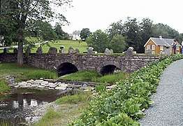
The Nordland Line runs through Røra, and Røra Station is served hourly or more often by the Trøndelag Commuter Rail.[8] European Route E6 also runs through Røra. It connects to Norwegian National Road 755 that runs through Sakshaug and onwards to Utøy and Mosvik. At Straumen, the road crosses the preserved Straumen Bridge and on the Inderøy–Mosvik border where it crosses the Skarnsund Bridge. National Road 761 runs from Sakshaug north through Sandvollan before intersecting with E6 south of Steinkjer. There is a limited bus service provided by TrønderBilene.[9]
Culture
There are a number of cultural activities in Inderøy. The Inderøy Upper Secondary School has a music, dance, and drama line, and the county's music service is also located in Straumen. Quite a number of local activities are oriented around culture, including the annual jazz festival Soddjazz. There is also a gallery, Nils Aas Kunstverksted and numerous small artist workshops. The newspaper Inderøyningen is published in Straumen and covers the municipality.
Attractions
Most tourist attractions are connected to The Golden Detour. Among these are local farms and a distillery that sell locally produced foods and beverages, as well as artist workshops and a fishing centre.
Notable residents
- Nils Aas (1933–2004) artist
- Ingrid Bolsø Berdal (born 1980) actor
- Inger Lise Gjørv (1938–2009) politician and governor
- Per Egil Hegge (born 1940) journalist; former editor of Aftenposten
- Christian Leden (1882–1957) Arctic explorer, scientist and composer
- Håkon Løken (1859–1823) journalist and lawyer
- Ole Richter (1829–1888) lawyer, politician and prime minister
- Johannes B. Wist (1864–1923) Norwegian American journalist and author
References
- ↑ "Navn på steder og personer: Innbyggjarnamn" (in Norwegian). Språkrådet. Retrieved 2015-12-01.
- ↑ Statistisk sentralbyrå (2017). "Table: 06913: Population 1 January and population changes during the calendar year (M)" (in Norwegian). Retrieved 2017-09-26.
- ↑ Jukvam, Dag (1999). "Historisk oversikt over endringer i kommune- og fylkesinndelingen" (PDF) (in Norwegian). Statistisk sentralbyrå.
- ↑ Rygh, Oluf (1903). Norske gaardnavne: Nordre Trondhjems amt (dokpro.uio.no) (in Norwegian) (15 ed.). Kristiania, Norge: W. C. Fabritius & sønners bogtrikkeri. p. 175.
- ↑ Norske Kommunevåpen (1990). "Nye kommunevåbener i Norden". Retrieved 2 November 2008.
- ↑ "Kommunesammenslåingen - kommunevåpen og rammer for profilering avklart" (PDF) (in Norwegian). Nye Inderøy kommune.
- ↑ "Table: 04813: Members of the local councils, by party/electoral list at the Municipal Council election (M)" (in Norwegian). Statistics Norway. 2015.
- ↑ Norwegian National Rail Administration. "Røra stasjon" (in Norwegian). Retrieved 26 October 2009.
- ↑ Nord-Trøndelag County Municipality. "Rutetabeller" (in Norwegian). Retrieved 26 October 2009.
External links
| Wikimedia Commons has media related to Inderøy. |

- Municipal fact sheet from Statistics Norway (in Norwegian)
- The Golden Detour
| |||||||
| |||||||
| |||||||
