Grong
| Grong kommune Kråangke | |||
|---|---|---|---|
| Municipality | |||
 Grong in early August 2007 | |||
| |||
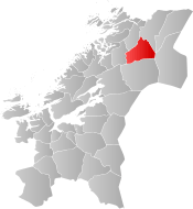 Grong within Trøndelag | |||
| Coordinates: 64°31′53″N 12°37′12″E / 64.53139°N 12.62000°ECoordinates: 64°31′53″N 12°37′12″E / 64.53139°N 12.62000°E | |||
| Country | Norway | ||
| County | Trøndelag | ||
| District | Namdalen | ||
| Established | 1 Jan 1838 | ||
| Administrative centre | Medjå | ||
| Government | |||
| • Mayor (2011) | Skjalg Åkerøy (Ap) | ||
| Area | |||
| • Total | 1,136.17 km2 (438.68 sq mi) | ||
| • Land | 1,097.64 km2 (423.80 sq mi) | ||
| • Water | 38.53 km2 (14.88 sq mi) 3.4% | ||
| Area rank | #87 in Norway | ||
| Population (2017) | |||
| • Total | 2,467 | ||
| • Rank | #298 in Norway | ||
| • Density | 2.2/km2 (6/sq mi) | ||
| • Change (10 years) | 3.4% | ||
| Demonym(s) | Grongning[1] | ||
| Time zone | UTC+01:00 (CET) | ||
| • Summer (DST) | UTC+02:00 (CEST) | ||
| ISO 3166 code | NO-5045 | ||
| Official language form | Neutral | ||
| Website |
grong | ||


![]()
The 1,136-square-kilometre (439 sq mi) municipality is the 87th largest by area out of the 422 municipalities in Norway. Grong is the 298th most populous municipality in Norway with a population of 2,467. The municipality's population density is 2.2 inhabitants per square kilometre (5.7/sq mi) and its population has increased by 3.4% over the last decade.[2]
General information
Grong was established as a municipality on 1 January 1838 (see formannskapsdistrikt). On 1 January 1901, the northwestern district of Grong (population: 1,046) was separated to form the new municipality of Høylandet. On 1 January 1923, the large municipality of Grong was divided into four smaller municipalities: Grong (population: 1,272) in the southwest, Harran (population: 630) in the centre, Røyrvik (population: 392) in the northeast, and Namsskogan (population: 469) in the northwest.
During the 1960s, there were many municipal mergers across Norway due to the work of the Schei Committee. On 1 January 1964, the neighboring municipalities of Harran (population: 1,085) and Grong (population: 1,962) were merged (back together) to form a new municipality called Grong.[3]
On 1 January 2018, the municipality switched from the old Nord-Trøndelag county to the new Trøndelag county.
Name
The municipality (originally the parish) is named after the old Grong farm (Old Norse: Granungar), since the first Grong Church was built there. The first element is grǫn which means "spruce" and the last element is the plural form of the suffix -ungr.[4]
Coat of arms
The coat of arms is from modern times; they were granted on 6 February 1987. The arms show three green triangles on a silver/gray background. The green triangles represent spruce trees (gran), making them canting arms since the name is supposedly derived from Granungar which means spruce. The number three symbolizes the three main villages in the municipality: Harran, Bergsmoen, and Medjå.[5]
Churches
The Church of Norway has two parishes (sokn) within the municipality of Grong. It is part of the Namdal prosti (deanery) in the Diocese of Nidaros.
| Parish (Sokn) | Church Name | Location of the Church | Year Built |
|---|---|---|---|
| Grong | Grong Church | Medjå | 1877 |
| Harran | Harran Church | Harran | 1874 |
| Gløshaug Church | Gartland | 1689 |
Geography
Grong is located along the river Namsen in the Namdalen valley. Two major tributaries of the Namsen flow through Grong too: the river Sanddøla and the river Neselva. The Bangsjøene lakes lie at the extreme southern border with Snåsa and Overhalla. The Blåfjella–Skjækerfjella National Park covers a small part of the southeastern part of Grong.
Government
All municipalities in Norway, including Grong, are responsible for primary education (through 10th grade), outpatient health services, senior citizen services, unemployment and other social services, zoning, economic development, and municipal roads. The municipality is governed by a municipal council of elected representatives, which in turn elect a mayor. The municipality falls under the Namdal District Court and the Frostating Court of Appeal.
Municipal council
The municipal council (Kommunestyre) of Grong is made up of 17 representatives that are elected to four year terms. Currently, the party breakdown is as follows:[6]
| Party Name | Name in Norwegian | Number of representatives | |
|---|---|---|---|
| Labour Party | Arbeiderpartiet | 9 | |
| Conservative Party | Høyre | 1 | |
| Centre Party | Senterpartiet | 5 | |
| Socialist Left Party | Sosialistisk Venstreparti | 2 | |
| Total number of members: | 17 | ||
Transportation
The European route E6 highway follows the river Namsen across the municipality, as does the Nordland Line. The two main stations on the Nordland Line are Grong Station in Medjå and Harran Station in Harran. The old Namsos Line railway used to run from Grong to Namsos, but that is now closed.
Media gallery
 The high school in Grong
 Train station in Grong
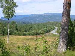
 County road from Grong to Sweden
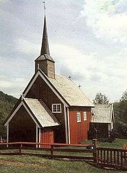 The old Gløshaug church in Gartland
References
- ↑ "Navn på steder og personer: Innbyggjarnamn" (in Norwegian). Språkrådet. Retrieved 2015-12-01.
- ↑ Statistisk sentralbyrå (2017). "Table: 06913: Population 1 January and population changes during the calendar year (M)" (in Norwegian). Retrieved 2017-09-26.
- ↑ Jukvam, Dag (1999). "Historisk oversikt over endringer i kommune- og fylkesinndelingen" (PDF) (in Norwegian). Statistisk sentralbyrå.
- ↑ Rygh, Oluf (1903). Norske gaardnavne: Nordre Trondhjems amt (dokpro.uio.no) (in Norwegian) (15 ed.). Kristiania, Norge: W. C. Fabritius & sønners bogtrikkeri. p. 295.
- ↑ "Civic heraldry of Norway - Norske Kommunevåpen". Heraldry of the World. Retrieved 2018-04-23.
- ↑ "Table: 04813: Members of the local councils, by party/electoral list at the Municipal Council election (M)" (in Norwegian). Statistics Norway. 2015.
External links
| Wikimedia Commons has media related to Grong. |

- Municipal fact sheet from Statistics Norway (in Norwegian)
| |||||||
| |||||||
| |||||||

| Authority control |
|---|