Rennebu
| Rennebu kommune | |||
|---|---|---|---|
| Municipality | |||
 Map of the municipality | |||
| |||
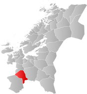 Rennebu within Trøndelag | |||
| Coordinates: 62°49′51″N 09°52′28″E / 62.83083°N 9.87444°ECoordinates: 62°49′51″N 09°52′28″E / 62.83083°N 9.87444°E | |||
| Country | Norway | ||
| County | Trøndelag | ||
| District | Orkdalen | ||
| Established | 1839 | ||
| Administrative centre | Berkåk | ||
| Government | |||
| • Mayor (2015) | Ola Øie (Ap) | ||
| Area | |||
| • Total | 947.97 km2 (366.01 sq mi) | ||
| • Land | 925.11 km2 (357.19 sq mi) | ||
| • Water | 22.86 km2 (8.83 sq mi) 2.4% | ||
| Area rank | #115 in Norway | ||
| Population (2017) | |||
| • Total | 2,556 | ||
| • Rank | #288 in Norway | ||
| • Density | 2.8/km2 (7/sq mi) | ||
| • Change (10 years) | -3.0% | ||
| Demonym(s) | Rennbygg[1] | ||
| Time zone | UTC+01:00 (CET) | ||
| • Summer (DST) | UTC+02:00 (CEST) | ||
| ISO 3166 code | NO-5022 | ||
| Official language form | Neutral | ||
| Website |
rennebu | ||

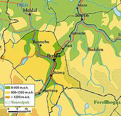
Rennebu is a municipality in Trøndelag county, Norway. It is part of the Orkdalen region. The administrative centre of the municipality is the village of Berkåk, located along European route E6. The majority of the population lives in Berkåk, Innset, Stamnan, Ulsberg, Voll, and Nerskogen.
The 948-square-kilometre (366 sq mi) municipality is the 115th largest by area out of the 422 municipalities in Norway. Rennebu is the 288th most populous municipality in Norway with a population of 2,556. The municipality's population density is 2.8 inhabitants per square kilometre (7.3/sq mi) and its population has decreased by 3% over the last decade.[2]
General information

The municipality of Rennebu was established in 1839 when it was separated from the municipality of Meldal. Initially, the population was 2,368. On 1 January 1966, the parish of Innset (population: 420) was transferred from Kvikne municipality (and also from Hedmark county) to Rennebu (and Sør-Trøndelag county). Then on 1 January 1970, the Garlia area (population: 5) was transferred from Tynset (and Hedmark county) to Rennebu (and Sør-Trøndelag).[3] On 1 January 2018, the municipality switched from the old Sør-Trøndelag county to the new Trøndelag county.
Name
The Old Norse form of the name was Rennabú. The first element is, maybe, the plural genitive case of renna which means "journey", "march", or "road". Probably because two old important roads cross the municipality: one follows the Orkla river from the Orkdalsfjord (part of the Trondheimsfjord) to the village of Berkåk where it connects with the road from the Gudbrandsdalen valley and Oppdal to Gauldalen and Trondheim (today the European route E6). The last element is bú which means "rural district".[4]
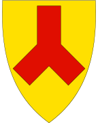
Coat of arms
The coat of arms is from modern times (approved on 19 February 1982). It shows the outline of the local church, Rennebu kirke (erected 1669), which is one of the oldest (and very few) churches in Norway based on a Y-shaped outline.[5]
Churches
The Church of Norway has three parishes (sokn) within the municipality of Rennebu. It is part of the Gauldal prosti (deanery) in the Diocese of Nidaros.
| Parish (Sokn) | Church Name | Location of the Church | Year Built |
|---|---|---|---|
| Berkåk | Berkåk Church | Berkåk | 1878 |
| Innset | Innset Church | Innset | 2000 |
| Rennebu | Rennebu Church | Voll | 1669 |
| Nerskogen Chapel | Nerskogen | 1962 |
Geography

Rennebu mainly consists of uncultivated areas of mountains, lakes, moors, and forests. The highest point is the 1,548-metre (5,079 ft) tall Svarthetta. The mountain Ilfjellet is located in the northeastern part of the municipality.
The Orkla River flows through the municipality from south to north in the Orkdalen valley. The northeasternmost part of the Trollheimen mountain range also lies within the municipality of Rennebu.
The municipality is surrounded by Oppdal and Rindal to the west, Meldal to the north, Midtre Gauldal to the east, and Tynset to the south. The Forollhogna National Park lies in the extreme southeastern part of the municipality.
Government
All municipalities in Norway, including Rennebu, are responsible for primary education (through 10th grade), outpatient health services, senior citizen services, unemployment and other social services, zoning, economic development, and municipal roads. The municipality is governed by a municipal council of elected representatives, which in turn elect a mayor. The municipality falls under the Sør-Trøndelag District Court and the Frostating Court of Appeal.
Municipal council
The municipal council (Kommunestyre) of Rennebu is made up of 21 representatives that are elected to four year terms. Currently, the party breakdown is as follows:[6]
| Party Name | Name in Norwegian | Number of representatives | |
|---|---|---|---|
| Labour Party | Arbeiderpartiet | 8 | |
| Christian Democratic Party | Kristelig Folkeparti | 4 | |
| Centre Party | Senterpartiet | 6 | |
| Local Lists | Lokale lister | 3 | |
| Total number of members: | 21 | ||
References
- ↑ "Navn på steder og personer: Innbyggjarnamn" (in Norwegian). Språkrådet. Retrieved 2015-12-01.
- ↑ Statistisk sentralbyrå (2017). "Table: 06913: Population 1 January and population changes during the calendar year (M)" (in Norwegian). Retrieved 2017-10-08.
- ↑ Jukvam, Dag (1999). "Historisk oversikt over endringer i kommune- og fylkesinndelingen" (PDF) (in Norwegian). Statistisk sentralbyrå.
- ↑ Rygh, Oluf (1901). Norske gaardnavne: Søndre Trondhjems amt (in Norwegian) (14 ed.). Kristiania, Norge: W. C. Fabritius & sønners bogtrikkeri. p. 166.
- ↑ Norske Kommunevåpen (1990). "Nye kommunevåbener i Norden". Retrieved 27 October 2008.
- ↑ "Table: 04813: Members of the local councils, by party/electoral list at the Municipal Council election (M)" (in Norwegian). Statistics Norway. 2015.
External links
| Wikimedia Commons has media related to Rennebu. |

- Municipal fact sheet from Statistics Norway (in Norwegian)
| |||||||
| |||||||
| |||||||

| Authority control |
|---|