Hemne
| Hemne kommune | |||
|---|---|---|---|
| Municipality | |||
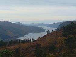
.jpg) View of Kyrksæterøra | |||
| |||
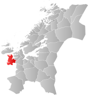 Hemne within Trøndelag | |||
| Coordinates: 63°16′16″N 09°03′21″E / 63.27111°N 9.05583°ECoordinates: 63°16′16″N 09°03′21″E / 63.27111°N 9.05583°E | |||
| Country | Norway | ||
| County | Trøndelag | ||
| District | Fosen | ||
| Established | 1 Jan 1838 | ||
| Administrative centre | Kyrksæterøra | ||
| Government | |||
| • Mayor (2015) | Odd Jarle Svanem (Sp) | ||
| Area | |||
| • Total | 669.90 km2 (258.65 sq mi) | ||
| • Land | 635.10 km2 (245.21 sq mi) | ||
| • Water | 34.80 km2 (13.44 sq mi) 5.2% | ||
| Area rank | #169 in Norway | ||
| Population (2017) | |||
| • Total | 4,259 | ||
| • Rank | #225 in Norway | ||
| • Density | 6.7/km2 (17/sq mi) | ||
| • Change (10 years) | 0.3% | ||
| Demonym(s) | Hemnværing[1] | ||
| Time zone | UTC+01:00 (CET) | ||
| • Summer (DST) | UTC+02:00 (CEST) | ||
| ISO 3166 code | NO-5011 | ||
| Official language form | Neutral | ||
| Website |
hemne | ||

Hemne is a municipality in Trøndelag county, Norway. It is part of the Fosen region. The administrative centre of the municipality is the village of Kyrksæterøra. Other villages include Heim, Hellandsjøen, Holla, and Vinjeøra. The European route E39 highway runs through the southern part of Hemne.[2]
The 670-square-kilometre (260 sq mi) municipality is the 169th largest by area out of the 422 municipalities in Norway. Hemne is the 225th most populous municipality in Norway with a population of 4,259. The municipality's population density is 6.7 inhabitants per square kilometre (17/sq mi) and its population has increased by 0.3% over the last decade.[3]
General information
Hemne was established as a municipality on 1 January 1838 (see formannskapsdistrikt). On 1 January 1911, the northern district of Heim (population: 1,533) was separated from Hemne to form a municipality of its own. This left Hemne with 3,425 residents. On 1 July 1924, Hemne was further divided with the eastern district of Snillfjord (population: 776) and the southern district of Vinje (population: 716) were separated from Hemne to form separate municipalities. After the division, Hemne had 2,030 residents remaining.
During the 1960s, there were many municipal mergers across Norway due to the work of the Schei Committee. Then on 1 January 1964, the neighboring municipalities of Vinje (population: 576) and the parts of Heim west of the Hemnfjorden (population: 711), were merged into Hemne.[4] On 1 January 2008, the Fossdalen farm (population: 4) was transferred from Rindal (in Møre og Romsdal county) to Hemne (in Sør-Trøndelag county).[5]
On 1 January 2018, the municipality of Hemne switched from the old Sør-Trøndelag county to the new Trøndelag county.
On 1 January 2020, the municipality of Hemne will merge with the Ytre Snillfjord area in the neighboring municipality of Snillfjord and the neighboring municipality of Halsa to form the new municipality of Heim (resurrecting an old name for the area).[6]
Name
The name (Old Norse: Hefn) originally belonged to the Hemnfjorden. The name is derived from the word hǫfn which means "port" or "haven" (referring to the good port of Hemnskjel). Before 1918, the name was written Hevne.[7]
Coat of arms
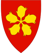
The coat of arms is from modern times. They were granted on 14 June 1991. The arms show five yellow hazelnuts on a red background. They symbolize the relatively large hazel forests near the village, which was of economic importance for the village in previous times.[8]
Churches
The Church of Norway has three parishes (sokn) within the municipality of Hemne. It is part of the Orkdal prosti (Deanery) within the Diocese of Nidaros.
| Parish (Sokn) | Church Name | Location of the Church | Year Built |
|---|---|---|---|
| Heim | Heim Church | Heim | 1883 |
| Hemne | Hemne Church | Kyrksæterøra | 1817 |
| Vinje | Vinje Church | Vinjeøra | 1820 |
Government
All municipalities in Norway, including Hemne, are responsible for primary education (through 10th grade), outpatient health services, senior citizen services, unemployment and other social services, zoning, economic development, and municipal roads. The municipality is governed by a municipal council of elected representatives, which in turn elect a mayor. The municipality falls under the Sør-Trøndelag District Court and the Frostating Court of Appeal.
Municipal council
The municipal council (Kommunestyre) of Hemne is made up of 23 representatives that are elected to four year terms. Currently, the party breakdown is as follows:[9]
| Party Name | Name in Norwegian | Number of representatives | |
|---|---|---|---|
| Labour Party | Arbeiderpartiet | 10 | |
| Progress Party | Fremskrittspartiet | 1 | |
| Conservative Party | Høyre | 2 | |
| Christian Democratic Party | Kristelig Folkeparti | 1 | |
| Centre Party | Senterpartiet | 7 | |
| Local Lists | Lokale lister | 2 | |
| Total number of members: | 23 | ||
Geography
Hemne is bordered on the east by the municipalities of Snillfjord and Orkdal, on the south by Rindal and Surnadal (both in Møre og Romsdal county), and in the west by Aure and Halsa. To the north, across the waters of the Trondheimsleia lies Hitra.
The Hemnfjorden forms the border between Hemne and Snillfjord. The Vinjefjorden is located in the southwestern side of the municipality and the lake Vasslivatnet lies in the southeast. In the south near Vinjeøra, there are several hiking trails to mountain lodges such as Sollia.
The Grønkjølen Nature Reserve lies in the extreme south of the municipality.[10]
References
- ↑ "Navn på steder og personer: Innbyggjarnamn" (in Norwegian). Språkrådet. Retrieved 2015-12-01.
- ↑ Stokken, John, ed. (2017-06-17). "Hemne". Store norske leksikon (in Norwegian). Kunnskapsforlaget. Retrieved 2017-10-05.
- ↑ Statistisk sentralbyrå (2017). "Table: 06913: Population 1 January and population changes during the calendar year (M)" (in Norwegian). Retrieved 2017-10-05.
- ↑ Jukvam, Dag (1999). "Historisk oversikt over endringer i kommune- og fylkesinndelingen" (PDF) (in Norwegian). Statistisk sentralbyrå.
- ↑ Statistisk sentralbyrå (2001). "1612 Hemne. Population 1 January and population changes during the year. 1951-" (in Norwegian).
- ↑ "Ny kommune - Halsa, Snillfjord og Hemne" (in Norwegian). Retrieved 2017-10-05.
- ↑ Rygh, Oluf (1901). Norske gaardnavne: Søndre Trondhjems amt (in Norwegian) (14 ed.). Kristiania, Norge: W. C. Fabritius & sønners bogtrikkeri. p. 81.
- ↑ Norske Kommunevåpen (1990). "Nye kommunevåbener i Norden". Retrieved 25 October 2008.
- ↑ "Table: 04813: Members of the local councils, by party/electoral list at the Municipal Council election (M)" (in Norwegian). Statistics Norway. 2015.
- ↑ "Grønkjølen". Mijlø-direktoratet. Retrieved August 7, 2017.
External links


- Municipal fact sheet from Statistics Norway (in Norwegian)
| |||||||
| |||||||
| |||||||
