Klæbu
| Klæbu kommune | |||
|---|---|---|---|
| Municipality | |||
 | |||
| |||
 Klæbu within Trøndelag | |||
| Coordinates: 63°16′34″N 10°30′51″E / 63.27611°N 10.51417°ECoordinates: 63°16′34″N 10°30′51″E / 63.27611°N 10.51417°E | |||
| Country | Norway | ||
| County | Trøndelag | ||
| District | Trondheim Region | ||
| Established | 1 Jan 1838 | ||
| Administrative centre | Klæbu | ||
| Government | |||
| • Mayor (2015) | Kirsti Tømmervold (Ap) | ||
| Area | |||
| • Total | 186.36 km2 (71.95 sq mi) | ||
| • Land | 175.06 km2 (67.59 sq mi) | ||
| • Water | 11.30 km2 (4.36 sq mi) 6% | ||
| Area rank | #337 in Norway | ||
| Population (2017) | |||
| • Total | 6,050 | ||
| • Rank | #173 in Norway | ||
| • Density | 34.6/km2 (90/sq mi) | ||
| • Change (10 years) | 10.5% | ||
| Demonym(s) | Klæbygg[1] | ||
| Time zone | UTC+01:00 (CET) | ||
| • Summer (DST) | UTC+02:00 (CEST) | ||
| ISO 3166 code | NO-5030 | ||
| Official language form | Bokmål | ||
| Website |
klabu | ||


Klæbu is a municipality in Trøndelag county, Norway. It is located in the southern part of the Trondheim Region, about 20 kilometres (12 mi) south of the city of Trondheim. The administrative center is the village of Klæbu. The other major village in Klæbu municipality is Tanem.
Even though agriculture has traditionally been the main industry for Klæbu, the municipality now functions more as a commuter town of Trondheim, where many of Klæbu's inhabitants work or attend school.
The 186-square-kilometre (72 sq mi) municipality is the 337th largest by area out of the 422 municipalities in Norway. Klæbu is the 173rd most populous municipality in Norway with a population of 6,050. The municipality's population density is 34.6 inhabitants per square kilometre (90/sq mi) and its population has increased by 10.5% over the last decade.[2]
General information
The municipality of Klæbu was established on 1 January 1838 (see formannskapsdistrikt). On 1 January 1899, the small northwestern part of Klæbu (population: 533) was separated from Klæbu to form the new municipality of Tiller.[3]
On 1 January 2018, the municipality switched from the old Sør-Trøndelag county to the new Trøndelag county.
On 1 January 2020, the municipality of Klæbu is going to merge with the municipality Trondheim to the north.[4][5]
Name
The Old Norse form of the name was Kleppabú. The first element is the plural genitive case of kleppr which means 'rocky hill' and the last element is bú which means 'rural district'. The district/parish has a lot of small rocky hills.[6]
Coat of arms
The coat of arms is from modern times; they were granted on 8 July 1983. The silver and blue arms symbolize the Trangfossen waterfall in the Nidelva river, which is now the deepest canyon in Norway measuring 56 meters (183 feet). The river has been of great importance for the local development, for agriculture and hydroelectricity generation, hence the use of the waterfall as a typical symbol for the municipality. The waterfall is no longer visible as that part of the river became part of Bjørsjøen lake after the building of the dam at Hyttfossen.[7]
Churches
The Church of Norway has one parish (sokn) within the municipality of Klæbu. It is part of the Heimdal prosti (deanery) in the Diocese of Nidaros.
| Parish (Sokn) | Church Name | Location of the Church | Year Built |
|---|---|---|---|
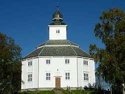
| Klæbu | Klæbu Church | Klæbu | 1790 |
| Vassfjell Chapel | Vassfjellet mountain | 1974 |
Geography
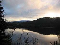
The Nidelva river, which runs through Klæbu, is a large source of hydroelectric power with a total of 3 power stations within the municipality borders. The river runs north from the lake Selbusjøen. The mountain Vassfjellet is located along the western border with Melhus.
The landlocked municipality of Klæbu has three municipalities that border it: Melhus is located to the west and south, Selbu is located to the east, and Trondheim is to the north.
Media
The newspaper KlæbuPosten is published in Klæbu.[8]
Government
All municipalities in Norway, including Klæbu, are responsible for primary education (through 10th grade), outpatient health services, senior citizen services, unemployment and other social services, zoning, economic development, and municipal roads. The municipality is governed by a municipal council of elected representatives, which in turn elect a mayor. The municipality falls under the Sør-Trøndelag District Court and the Frostating Court of Appeal.
Municipal council
The municipal council (Kommunestyre) of Klæbu is made up of 23 representatives that are elected to four year terms. Currently, the party breakdown is as follows:[9]
| Party Name | Name in Norwegian | Number of representatives | |
|---|---|---|---|
| Labour Party | Arbeiderpartiet | 9 | |
| Progress Party | Fremskrittspartiet | 2 | |
| Conservative Party | Høyre | 3 | |
| Green Party | Miljøpartiet De Grønne | 1 | |
| Centre Party | Senterpartiet | 3 | |
| Socialist Left Party | Sosialistisk Venstreparti | 2 | |
| Liberal Party | Venstre | 3 | |
| Total number of members: | 23 | ||
References
- ↑ "Navn på steder og personer: Innbyggjarnamn" (in Norwegian). Språkrådet. Retrieved 2015-12-01.
- ↑ Statistisk sentralbyrå (2017). "Table: 06913: Population 1 January and population changes during the calendar year (M)" (in Norwegian). Retrieved 2017-10-08.
- ↑ Jukvam, Dag (1999). "Historisk oversikt over endringer i kommune- og fylkesinndelingen" (PDF) (in Norwegian). Statistisk sentralbyrå.
- ↑ Trondheim Kommune (17 June 2016). "Ja til sammenslåing av Klæbu og Trondheim".
- ↑ "Bakgrunn - kommunesammenslåing" (in Norwegian). Trondheim kommune. Retrieved 2018-03-12.
- ↑ Rygh, Oluf (1901). Norske gaardnavne: Søndre Trondhjems amt (in Norwegian) (14 ed.). Kristiania, Norge: W. C. Fabritius & sønners bogtrikkeri. p. 364.
- ↑ Norske Kommunevåpen (1990). "Nye kommunevåbener i Norden". Retrieved 26 October 2008.
- ↑ KlæbuPosten at Kommunenvår.no.
- ↑ "Table: 04813: Members of the local councils, by party/electoral list at the Municipal Council election (M)" (in Norwegian). Statistics Norway. 2015.
External links
| Wikimedia Commons has media related to Klæbu. |

- Municipal fact sheet from Statistics Norway (in Norwegian)
- Klæbu church (in Norwegian)
| |||||||
| |||||||
| |||||||

| Authority control |
|---|