Leka, Norway
| Leka kommune | |||
|---|---|---|---|
| Municipality | |||
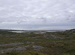 Skeisnesset geological reserve | |||
| |||
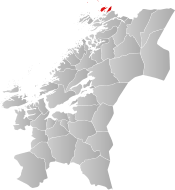 Leka within Trøndelag | |||
| Coordinates: 65°05′17″N 11°37′01″E / 65.08806°N 11.61694°ECoordinates: 65°05′17″N 11°37′01″E / 65.08806°N 11.61694°E | |||
| Country | Norway | ||
| County | Trøndelag | ||
| District | Namdalen | ||
| Established | 1 Oct 1860 | ||
| Administrative centre | Leknes | ||
| Government | |||
| • Mayor (2011) | Per Helge Johansen (Sp) | ||
| Area | |||
| • Total | 110.02 km2 (42.48 sq mi) | ||
| • Land | 108.33 km2 (41.83 sq mi) | ||
| • Water | 1.69 km2 (0.65 sq mi) 1.5% | ||
| Area rank | #374 in Norway | ||
| Population (2017) | |||
| • Total | 584 | ||
| • Rank | #415 in Norway | ||
| • Density | 5.4/km2 (14/sq mi) | ||
| • Change (10 years) | 0.2% | ||
| Demonym(s) | Lekværing[1] | ||
| Time zone | UTC+01:00 (CET) | ||
| • Summer (DST) | UTC+02:00 (CEST) | ||
| ISO 3166 code | NO-5052 | ||
| Official language form | Neutral | ||
| Website |
leka | ||


Leka is a municipality in Trøndelag county, Norway. It is part of the Namdalen region. The administrative centre of the municipality is the village of Leknes on the island of Leka. Other villages in Leka include Sør-Gutvika and Madsøygrenda. The island municipality includes all of the island of Leka and part of the island of Austra as well as hundreds of smaller surrounding islands and skerries.
.jpg)
Primarily a fishing and farming community, Leka is the northernmost municipality in Trøndelag county. The island of Leka has been inhabited for at least 10,000 years, as evidenced by cave drawings in the Solsem section of the island.
The 110-square-kilometre (42 sq mi) municipality is the 374th largest by area out of the 422 municipalities in Norway. Leka is the 415th most populous municipality in Norway with a population of 584. The municipality's population density is 5.4 inhabitants per square kilometre (14/sq mi) and its population has increased by 0.2% over the last decade.[2]
General information
The municipality of Leka was established on 1 October 1860 when it was separated from the large municipality of Kolvereid. Initially, the population of Leka was 1,702. On 1 January 1909, the southern district of Leka (population: 881) was separated from Leka to form the new municipality of Gravvik. This left Leka was 1,209 residents. The borders of Leka have not changed since then.[3] On 1 January 2018, the municipality switched from the old Nord-Trøndelag county to the new Trøndelag county.
On 8 June 2017, the Norwegian Parliament, the Storting, voted to merge the municipalities of Leka, Vikna, Nærøy, and Bindal to form one, large municipality effective 1 January 2020.[4] Leka and Bindal municipalities rejected the merger, but Vikna and Nærøy will merge on that date to form the new municipality of Nærøysund.[5]
Toponomy
The Old Norse form of the name was Leka. The meaning of the name is unknown, but it may come from the word lekke which can mean "gravelly ground".[6][7]
Coat of arms
The coat of arms is from modern times; they were granted on 21 April 1989. The arms show the golden wing and claw of an eagle on a red background. This is a reference to an incident which supposedly occurred in 1932, in which a three-year-old girl disappeared on the island, and was subsequently discovered beneath the nest of a White-tailed eagle.[6][8][9]
Churches
The Church of Norway has one parish (sokn) within the municipality of Leka. It is part of the Namdal prosti (deanery) in the Diocese of Nidaros.
| Parish (Sokn) | Church Name | Location of the Church | Year Built |
|---|---|---|---|
| Leka | Leka Church | Leknes | 1867 |
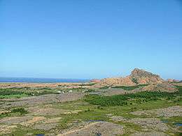
Geography
.jpg)
Leka is an island municipality encompassing the main island of Leka, the western part of the island of Austra (with the biggest locality being Gutvik), and many other small islands in the surrounding area. The tiny island groups of Sklinna and Horta lie to the west of the main islands. Sklinna Lighthouse is located in the westernmost part of the municipality. Leka borders Vikna and Nærøy municipalities to the south and Bindal (in Nordland county) to the north.
History
Dated to the Viking Age, the burial mound Herlaugshaugen is one of the largest (in Norway) from that era.[10]
Government
All municipalities in Norway, including Leka, are responsible for primary education (through 10th grade), outpatient health services, senior citizen services, unemployment and other social services, zoning, economic development, and municipal roads. The municipality is governed by a municipal council of elected representatives, which in turn elect a mayor. The municipality falls under the Namdal District Court and the Frostating Court of Appeal.
Municipal council
The municipal council (Kommunestyre) of Leka is made up of 15 representatives that are elected to four year terms. Currently, the party breakdown is as follows:[11]
| Party Name | Name in Norwegian | Number of representatives | |
|---|---|---|---|
| Labour Party | Arbeiderpartiet | 3 | |
| Centre Party | Senterpartiet | 9 | |
| Socialist Left Party | Sosialistisk Venstreparti | 1 | |
| Liberal Party | Venstre | 2 | |
| Total number of members: | 15 | ||
Politics
In the 2007 municipal elections, Leka had the highest vote for the Centre Party in Norway, at 69.3 per cent.
Transportation
The island part of Leka (Skei) is connected to Gutvik by a ferry line, operated by Lekaferja.
References
- ↑ "Navn på steder og personer: Innbyggjarnamn" (in Norwegian). Språkrådet. Retrieved 2015-12-01.
- ↑ Statistisk sentralbyrå (2017). "Table: 06913: Population 1 January and population changes during the calendar year (M)" (in Norwegian). Retrieved 2017-09-09.
- ↑ Jukvam, Dag (1999). "Historisk oversikt over endringer i kommune- og fylkesinndelingen" (PDF) (in Norwegian). Statistisk sentralbyrå.
- ↑ "Kommunesammenslåing Nærøy, Vikna, Leka, og Bindal" (PDF) (in Norwegian). Leka kommune. 2017-08-21. Retrieved 2017-09-26.
- ↑ "Navn på ny kommune" (in Norwegian). Vikna kommune. 2018-02-05. Retrieved 2018-04-29.
- 1 2 Store norske leksikon. "Leka" (in Norwegian). Retrieved 2011-10-10.
- ↑ Rygh, Oluf (1903). Norske gaardnavne: Nordre Trondhjems amt (dokpro.uio.no) (in Norwegian) (15 ed.). Kristiania, Norge: W. C. Fabritius & sønners bogtrikkeri. p. 369.
- ↑ "Nord-Trøndelag fylke" (in Norwegian). Retrieved 2008-11-02.
- ↑ "Civic heraldry of Norway - Norske Kommunevåpen". Heraldry of the World. Retrieved 2018-05-05.
- ↑ Mysteriet på Herlaugshaugen fortsetter - Nærmere undersøkelser av Herlaugshaugen på Leka har ikke gitt flere svar på hva som skjuler seg i haugen. De har likevel kartlagt noen nye funn. [The mystery at Herlaugshaugen continues - Closer examinations of Herlaugshaugen at Leka has not given more answers about what is hiding in the mound. They have nevertheless identified some new discoveries.]
- ↑ "Table: 04813: Members of the local councils, by party/electoral list at the Municipal Council election (M)" (in Norwegian). Statistics Norway. 2015.
External links
| Wikimedia Commons has media related to Leka. |

- Municipal fact sheet from Statistics Norway (in Norwegian)
| |||||||
| |||||||
| |||||||
