Denver, Pennsylvania
| Borough of Denver | |
|---|---|
 | |
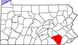
 Location of Denver in Lancaster County, Pennsylvania. | |
 Denver Location of Denver in Pennsylvania  Denver Denver (the US) | |
| Coordinates: 40°14′02″N 76°08′14″W / 40.23389°N 76.13722°WCoordinates: 40°14′02″N 76°08′14″W / 40.23389°N 76.13722°W | |
| Country | United States |
| State | Pennsylvania |
| County | Lancaster |
| Government | |
| • Mayor | Rodney L Redcay[1] |
| Area[2] | |
| • Total | 1.30 sq mi (3.36 km2) |
| • Land | 1.28 sq mi (3.31 km2) |
| • Water | 0.02 sq mi (0.05 km2) |
| Elevation | 394 ft (120 m) |
| Population (2010) | |
| • Total | 3,861 |
| • Estimate (2016)[3] | 3,867 |
| • Density | 3,023.46/sq mi (1,167.11/km2) |
| Time zone | UTC-5 (EST) |
| • Summer (DST) | UTC-4 (EDT) |
| ZIP code | 17517 |
| Area code(s) | 717 Exchanges: 335, 336 |
| FIPS code | 42-18888 |
Denver is a borough in Lancaster County, Pennsylvania, United States. The population was 3,332 at the 2000 census.
History
Founded by Hans Bucher, a Swiss immigrant, in 1735. Soon after it was called Bucher's Thal. In the 1800s, a train station was built and the town was renamed Union Station. Residents were growing weary of being referred to as a train station so in 1881, after researching post offices in the country, Adam Brubaker found only one named Denver. On November 1, 1881, the town was officially renamed Denver.[4]
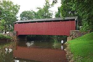
The Butcher's Mill Covered Bridge was listed on the National Register of Historic Places in 1980.[5]
Geography
Denver is located at 40°14′2″N 76°8′14″W / 40.23389°N 76.13722°W (40.233859, -76.137088).[6]
According to the United States Census Bureau, the borough has a total area of 1.3 square miles (3.4 km2), all of it land.
Demographics
| Historical population | |||
|---|---|---|---|
| Census | Pop. | %± | |
| 1910 | 933 | — | |
| 1920 | 1,125 | 20.6% | |
| 1930 | 1,203 | 6.9% | |
| 1940 | 1,428 | 18.7% | |
| 1950 | 1,658 | 16.1% | |
| 1960 | 1,875 | 13.1% | |
| 1970 | 2,248 | 19.9% | |
| 1980 | 2,018 | −10.2% | |
| 1990 | 2,861 | 41.8% | |
| 2000 | 3,332 | 16.5% | |
| 2010 | 3,861 | 15.9% | |
| Est. 2016 | 3,867 | [3] | 0.2% |
| Sources:[7][8][9] | |||
As of the census[8] of 2010, there were 15,391 people, 5,507 households, and 4,204 families residing in the 17517 zip code. The population density was 11,839.2 people per square mile (4571.1/km²). There were 5,705 housing units at an average density of 4388.5 per square mile (1694.4/km²). The racial makeup of the borough was 96.5% White, 1.2% Black or African American, 2.2% Asian, 0.03% Pacific Islander, 0.8% from other races, and 1.1% from two or more races. 2.28% of the population were Hispanic or Latino of any race.
There were 5,507 households, out of which 36.5% had children under the age of 18 living with them, 61.4% were married couples living together, 8.5% had a female householder with no husband present, and 25.4% were non-families. 21.1% of all households were made up of individuals, and 8.5% had someone living alone who was 65 years of age or older. The average household size was 2.63 and the average family size was 3.04.
In the borough the population was spread out, with 26.5% under the age of 18, 8.0% from 18 to 24, 24.1% from 25 to 44, 27.2% from 45 to 64, and 14.2% who were 65 years of age or older. The median age was 38.7 years. For every 100 females there were 98.2 males. For every 100 females age 18 and over, there were 98.1 males.
From the 2000 Census, The median income for a household in the borough was $49,085, and the median income for a family was $53,125. Males had a median income of $36,250 versus $23,715 for females. The per capita income for the borough was $19,706. About 4.5% of families and 5.2% of the population were below the poverty line, including 5.4% of those under age 18 and 3.3% of those age 65 or over.
Education
Denver Borough is served by the Cocalico School District.
Elementary
- Denver Elementary (Cocalico School District)
Middle
- Cocalico Middle (Cocalico School District)
High
- Cocalico High (Cocalico School District)
References
- ↑ "Mayor". Borough of Denver. Retrieved December 20, 2017.
- ↑ "2016 U.S. Gazetteer Files". United States Census Bureau. Retrieved August 14, 2017.
- 1 2 "Population and Housing Unit Estimates". Retrieved June 9, 2017.
- ↑ "About Denver Borough". Denver Borough. Retrieved December 20, 2017.
- ↑ National Park Service (July 9, 2010). "National Register Information System". National Register of Historic Places. National Park Service.
- ↑ "US Gazetteer files: 2010, 2000, and 1990". United States Census Bureau. February 12, 2011. Retrieved April 23, 2011.
- ↑ "Census of Population and Housing". U.S. Census Bureau. Archived from the original on May 12, 2015. Retrieved December 11, 2013.
- 1 2 "American FactFinder". United States Census Bureau. Archived from the original on September 11, 2013. Retrieved January 31, 2008.
- ↑ "Incorporated Places and Minor Civil Divisions Datasets: Subcounty Resident Population Estimates: April 1, 2010 to July 1, 2012". Population Estimates. U.S. Census Bureau. Archived from the original on June 17, 2013. Retrieved December 11, 2013.