Sadsbury Township, Lancaster County, Pennsylvania
| Sadsbury Township, Lancaster County, Pennsylvania | |
|---|---|
| Township | |
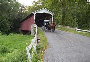 Mercer's Mill Covered Bridge on the Chester County border in Sadsbury Township. | |
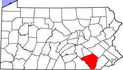
 Map of Lancaster County highlighting Sadsbury Township | |
| Country | United States |
| State | Pennsylvania |
| County | Lancaster |
| Settled | 1691 |
| Incorporated | 1729 |
| Government | |
| • Type | Board of Supervisors |
| Area[1] | |
| • Total | 19.66 sq mi (50.92 km2) |
| • Land | 19.56 sq mi (50.66 km2) |
| • Water | 0.10 sq mi (0.26 km2) |
| Population (2010) | |
| • Total | 3,395 |
| • Estimate (2016)[2] | 3,490 |
| • Density | 178.43/sq mi (68.89/km2) |
| Time zone | UTC-5 (Eastern (EST)) |
| • Summer (DST) | UTC-4 (EDT) |
| Area code(s) | 610, 717 |
| FIPS code | 42-071-67096 |
| Historical population | |||
|---|---|---|---|
| Census | Pop. | %± | |
| 2000 | 3,025 | — | |
| 2010 | 3,395 | 12.2% | |
| Est. 2016 | 3,490 | [2] | 2.8% |
| U.S. Decennial Census[3] | |||
Sadsbury Township is a township in east central Lancaster County, Pennsylvania, United States. The population was 3,395 at the 2010 census.[4]
History
In 1744, Sadsbury Township was split into two; the western part was organized as Bart Township and the eastern part remained Sadsbury Township.[5]
The Mercer's Mill Covered Bridge was listed on the National Register of Historic Places in 1980.[6]
Media
WTPA-LP 92.9 FM - Community Radio Station, Based in the Gap area of Sadsbury Township; which is located in the Northeast corner of the Township. Station Website
Geography
According to the United States Census Bureau, the township has a total area of 19.7 square miles (51.1 km²), all of it land.
Demographics
As of the census[7] of 2000, there were 3,025 people, 880 households, and 760 families residing in the township. The population density was 153.4 people per square mile (59.2/km²). There were 899 housing units at an average density of 45.6/sq mi (17.6/km²). The racial makeup of the township was 99.01% White, 0.26% African American, 0.07% Native American, 0.33% Asian, and 0.33% from two or more races. Hispanic or Latino of any race were 0.40% of the population.
There were 880 households, out of which 44.1% had children under the age of 18 living with them, 78.5% were married couples living together, 4.4% had a female householder with no husband present, and 13.6% were non-families. 11.6% of all households were made up of individuals, and 5.0% had someone living alone who was 65 years of age or older. The average household size was 3.44 and the average family size was 3.75.
In the township the population was spread out, with 35.5% under the age of 18, 9.1% from 18 to 24, 24.5% from 25 to 44, 21.4% from 45 to 64, and 9.6% who were 65 years of age or older. The median age was 30 years. For every 100 females, there were 100.1 males. For every 100 females age 18 and over, there were 102.8 males.
The median income for a household in the township was $53,750, and the median income for a family was $56,034. Males had a median income of $35,779 versus $29,545 for females. The per capita income for the township was $17,956. About 8.0% of families and 12.7% of the population were below the poverty line, including 21.0% of those under age 18 and 8.5% of those age 65 or over.
References
- ↑ "2016 U.S. Gazetteer Files". United States Census Bureau. Retrieved Aug 14, 2017.
- 1 2 "Population and Housing Unit Estimates". Retrieved June 9, 2017.
- ↑ "Census of Population and Housing". Census.gov. Retrieved June 4, 2016.
- ↑ https://factfinder.census.gov/faces/nav/jsf/pages/community_facts.xhtml?src=bkmk#
- ↑ Everets & Stewart, Historical Atlas of Lancaster Co. Pennsylvania Illustrated, 1875, p. XVI. Archived 2007-03-13 at the Wayback Machine.
- ↑ National Park Service (2010-07-09). "National Register Information System". National Register of Historic Places. National Park Service.
- ↑ "American FactFinder". United States Census Bureau. Retrieved 2008-01-31.
Coordinates: 39°52′24″N 75°59′29″W / 39.87333°N 75.99139°W