West Earl Township, Lancaster County, Pennsylvania
| West Earl Township, Pennsylvania | |
|---|---|
| Township | |
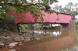 Bitzer's Mill Covered Bridge in West Earl Township | |
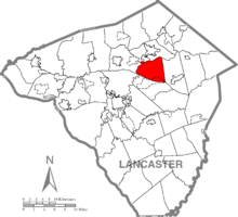 Map of Lancaster County, Pennsylvania highlighting West Earl Township | |
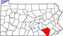 Map of Lancaster County, Pennsylvania | |
| Country | United States |
| State | Pennsylvania |
| County | Lancaster |
| Settled | 1719 |
| Incorporated | 1833 |
| Government | |
| • Type | Board of Supervisors |
| Area[1] | |
| • Total | 17.94 sq mi (46.47 km2) |
| • Land | 17.75 sq mi (45.97 km2) |
| • Water | 0.19 sq mi (0.50 km2) |
| Population (2010) | |
| • Total | 7,868 |
| • Estimate (2016)[2] | 8,298 |
| • Density | 467.52/sq mi (180.51/km2) |
| Time zone | UTC-5 (Eastern (EST)) |
| • Summer (DST) | UTC-4 (EDT) |
| FIPS code | 42-071-82824 |
| Website | West Earl Township |
| Historical population | |||
|---|---|---|---|
| Census | Pop. | %± | |
| 2000 | 6,766 | — | |
| 2010 | 7,868 | 16.3% | |
| Est. 2016 | 8,298 | [2] | 5.5% |
| U.S. Decennial Census[3] | |||
West Earl Township is a township in northeastern Lancaster County, Pennsylvania, United States. The population was 7,868 at the 2010 census.[4]
Floyd Landis, winner of the 2006 Tour de France, is from the unincorporated village of Farmersville in West Earl Township. Landis left such a mark on the Tour de France that when a contending rider completes a seemingly impossible long distance attack it is referred to as, "Doing a Landis" as Chris Froome did on Stage 19 of the 2018 Giro d'Italia.[5]
History
The Bridge in West Earl Township, Bitzer's Mill Covered Bridge, and Zook's Mill Covered Bridge are listed on the National Register of Historic Places.[6]
Geography
According to the United States Census Bureau, the township has a total area of 18.0 square miles (46.6 km²), of which, 17.6 square miles (45.7 km²) of it is land and 0.4 square miles (0.9 km²) of it (2.00%) is water.
Demographics
As of the census[7] of 2000, there were 6,766 people, 2,201 households, and 1,785 families residing in the township. The population density was 383.5 people per square mile (148.1/km²). There were 2,283 housing units at an average density of 129.4/sq mi (50.0/km²). The racial makeup of the township was 96.63% White, 0.35% African American, 0.06% Native American, 2.13% Asian, 0.47% from other races, and 0.35% from two or more races. Hispanic or Latino of any race were 1.51% of the population.
There were 2,201 households, out of which 37.9% had children under the age of 18 living with them, 71.7% were married couples living together, 6.8% had a female householder with no husband present, and 18.9% were non-families. 15.9% of all households were made up of individuals, and 8.2% had someone living alone who was 65 years of age or older. The average household size was 2.98 and the average family size was 3.36.
In the township the population was spread out, with 28.7% under the age of 18, 8.6% from 18 to 24, 25.0% from 25 to 44, 23.3% from 45 to 64, and 14.4% who were 65 years of age or older. The median age was 36 years. For every 100 females, there were 95.5 males. For every 100 females age 18 and over, there were 91.1 males.
The median income for a household in the township was $51,503, and the median income for a family was $54,360. Males had a median income of $37,227 versus $22,037 for females. The per capita income for the township was $21,457. About 5.1% of families and 8.4% of the population were below the poverty line, including 9.9% of those under age 18 and 9.8% of those age 65 or over.
Education
The township is served by the Conestoga Valley School District.
See also
References
- ↑ "2016 U.S. Gazetteer Files". United States Census Bureau. Retrieved Aug 14, 2017.
- 1 2 "Population and Housing Unit Estimates". Retrieved June 9, 2017.
- ↑ "Census of Population and Housing". Census.gov. Retrieved June 4, 2016.
- ↑ https://factfinder.census.gov/faces/nav/jsf/pages/community_facts.xhtml?src=bkmk#
- ↑ http://www.cyclingnews.com/news/bennett-defends-his-froome-did-a-landis-comments/. Missing or empty
|title=(help) - ↑ National Park Service (2010-07-09). "National Register Information System". National Register of Historic Places. National Park Service.
- ↑ "American FactFinder". United States Census Bureau. Retrieved 2008-01-31.
Coordinates: 40°07′00″N 76°09′59″W / 40.11667°N 76.16639°W