Cecil County, Maryland
| Cecil County, Maryland | ||
|---|---|---|
| County | ||
| Cecil County | ||
.jpg) Postcard. Elkton Armory. | ||
| ||
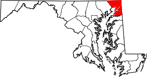 Location in the U.S. state of Maryland | ||
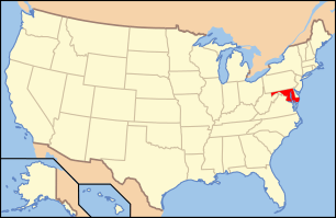 Maryland's location in the U.S. | ||
| Founded | June 6, 1674 | |
| Named for | Cecil Calvert | |
| Seat | Elkton | |
| Largest town | Elkton | |
| Area | ||
| • Total | 418 sq mi (1,083 km2) | |
| • Land | 346 sq mi (896 km2) | |
| • Water | 72 sq mi (186 km2), 17% | |
| Population (est.) | ||
| • (2017) | 102,746 | |
| • Density | 297/sq mi (115/km2) | |
| Congressional district | 1st | |
| Time zone | Eastern: UTC−5/−4 | |
| Website |
www | |

Cecil County is a county located in the U.S. state of Maryland. As of the 2010 census, the population was 101,108.[1] The county seat is Elkton.[2] The county was named for Cecil Calvert, 2nd Baron Baltimore (1605–1675), the first Proprietary Governor of the Province (colony) of Maryland. It is the only Maryland county that is part of the Philadelphia-Camden-Wilmington, PA-NJ-DE-MD Metropolitan Statistical Area.[3]
History
The area now known as Cecil County was an important trading center long before the county's official organization in 1674 by proclamation of Lord Baltimore. It had previously been a northeastern part of a much larger Baltimore County, in the northeastern portion of the Province. This had included present-day Baltimore City and county, Harford, Carroll, eastern Frederick, and portions of Howard and Anne Arundel counties. At the time of its founding, Cecil County also included modern Kent County and the border on the Eastern Shore of the Chesapeake Bay went as far south as the Chester River, until its later formation in 1706. The Piscataway traded with the Susquehannocks near Conowingo, and with Lenape of the Delaware valley and their Nanticoke allies near the Elk River and Elk Neck Peninsula. A southern tribe sometimes called the Shawnace also moved into what later became North East, Maryland.[4] Captain John Smith visited the area in 1608. William Claiborne, a Puritan trader based in Virginia, earlier established a trading post at what is now known as Garrett island at the mouth of the Susquehanna River near what became Perryville. Bohemian immigrant Augustine Herman lobbied for Cecil County's creation, and drew the 1674 maps, in exchange for which Herman received extensive land grants, including one developed as Bohemia Manor, where he eventually died. Another early developer was George Talbot, appointed Surveyor-General of Maryland in 1683, who came from Ballyconnell, County Cavan, Ireland.[5]
Until the American Revolution, Cecil County was an important shipping center, both within the colonies and abroad. It exported not only its own agricultural products but also animal skins from the west and tobacco from the south. St. Francis Xavier Church (Warwick, Maryland) begun as a Jesuit mission in 1704 and rebuilt in 1792, is one of Maryland's oldest churches, though now a museum. St. Mary Anne's Episcopal Church, authorized in 1706 and rebuilt in 1742 is another (and still in use, as well as maintaining a historic graveyard). West Nottingham Academy founded by Presbyterian Rev. Samuel Finley in 1744, educated Benjamin Rush and Richard Stockton, both of whom signed the Declaration of Independence, and still operates today (though disaffiliated from the Presbyterian church and with additional buildings). The Principio Furnace, founded in 1719, became an important exporter of pig iron. During the American Revolution both British and colonial troops traveled through Cecil County, although no major battles occurred within its borders. The Battle of Cooch's Bridge occurred in nearby Delaware, and both General Howe and General George Washington stopped in Elkton during the summer of 1777. Robert Alexander, the area's delegate to the Continental Congress of 1776, spoke with both sides but ultimately decided to go into exile in England without his wife. She remained a loyal Marylander and received a life estate in some of Elkton property that Maryland confiscated.
The War of 1812 caused Cecil County considerable damage. Not only did British Admiral George Cockburn blockade the upper Chesapeake bay, in response to musket fire from colonials at Welch Point, his troops destroyed a trading post known as Frenchtown. They tried to sail further up the Elk River to the county seat at Elkton, but turned back under fire from Fort Defiance, also hindered by a cable across the navigation channel. British troops also destroyed most of Havre de Grace in nearby Harford County, Maryland. Cockburn's ships then traveled up the Sassafras River, and, meeting resistance, destroyed Georgetown, Maryland and Fredericktown, Maryland. Avoiding Port Deposit which rumors called heavily defended, the British destroyed the Principio Iron Works, an important military target.
Port Deposit boomed after the Susquehanna Canal opened in 1812. Engineer James Rumsey, who grew up in Bohemia Manor before moving to Bath, Virginia (or Berkeley Springs, West Virginia), invented a steamboat which he demonstrated to George Washington, before traveling to London to secure patents against competition from John Finch. Rumsey died there in 1792, but his lawyer brother Benjamin Rumsey moved south to Joppa, Maryland and served as Maryland's Chief Justice for 25 years. Steamboats, using technology such as by Robert Fulton, came to dominate travel on the bay during the following decades. The Eagle, built in Philadelphia in 1813, transported travelers between Baltimore and Elkton, where they connected with stagecoaches to travel to Wilmington, Philadelphia and other points north. An 1802 attempt to build a canal to connect the Elk River to Christiana, Delaware (connecting the Chesapeake and Delaware watersheds) failed within two years. However, between 1824 and 1829, with financial support from the states of Maryland, Delaware and Pennsylvania, over 2600 workers built the 14 miles long Chesapeake and Delaware Canal, which became for a while the busiest canal in the new nation. The U.S. Army Corps of Engineers still operates it today, and Chesapeake City, Maryland, which had been Bohemia Manor until 1839, has a museum explaining the canal's importance. Railroads and bridges also proved economically important to Cecil County and surrounding region. The New Castle and Frenchtown Railroad began service in 1831. Railroads crisscrossed Cecil county within three decades, although they ultimately greatly reduced its importance as a trading center. Cities such as Philadelphia and Baltimore could achieve economies of scale impossible for the county's small Chesapeake ports. Even the railroad's Frenchtown section was abandoned in 1859, and the port became a ghost town (though other sections remain in use, operated by the Norfolk Southern Railway).
During the American Civil War, Perryville, Maryland became an important staging ground for Union troops. It had been the halfway point of the railroad line between Wilmington and Baltimore, but damage to the section into Baltimore caused Union troops to embark ferries at Perryville. No Civil War battles occurred in Cecil County, but residents had strongly divided loyalties. Slavery had declined from 3400 slaves in the county in 1790 to just 800 in 1850. The Underground Railroad had crossed through Cecil County, perhaps assisted by the 'Fighting Quaker,' former Congressman and U.S. Marshall John Conard, who moved to Northeast between 1834 and 1851 and was reburied at St. Mary Anne's Episcopal Church there`after his death in Philadelphia in 1857. Frederick Douglass crossed Cecil county on his road to freedom in 1838. While Jacob Tome made his fortune in the area and stayed, other Cecil county natives left in search of economic opportunity. David Davis moved to Illinois upon graduating from Yale Law School in 1835, where he became Abraham Lincoln's law partner and later served in that legislature as well as a judge, before moving to Washington D.C. to help President Lincoln, who later named him to the United States Supreme Court. Slavery's abolition affected many local property owners, as well as their slaves. After the war, Perryville again became a railroad town, and later received business from interstate highway travelers crossing the Susquehanna bridges. Although Cecil county had once been one of the wealthiest in Maryland and has worked hard recently to attract industry as well as tourist dollars, the average income of residents is now near that of Americans as a whole.[6]
Cecil County has a number of properties on the National Register of Historic Places.[7]
Politics, government and law
In the early post-Civil War period, Cecil County, having been generally pro-secession, leaned strongly towards the Democratic Party.[8] It was carried by the Democratic Party nominee in every Presidential election between 1868 and 1920 except that of 1896 when the Northeast was vigorously opposed to William Jennings Bryan’s “free silver” policy. Since Dwight Eisenhower carried the county in 1952, Cecil County has become a solidly Republican county. The last Democrat to carry the county was Jimmy Carter in 1976.
Prior to December 3, 2012, Cecil County was governed by county commissioners, the traditional form of county government in Maryland. On that date, Cecil County began governance under a new charter approved via voter referendum in November 2010, which authorized an elected County Executive and a five-member County Council, which separates the legislative and executive functions of local government (unlike the old "board of commissioner" system). Cecil County thus joined most of the other larger, increasingly urban and complex county governments in central Maryland with county executive-county council forms (such as Baltimore, Harford, Anne Arundel, Howard, Prince George's, and Montgomery counties.[9] Alan McCarthy (R) is the current County Executive.
| Year | Republican | Democratic | Third parties |
|---|---|---|---|
| 2016 | 63.8% 28,868 | 30.2% 13,650 | 6.1% 2,751 |
| 2012 | 58.4% 24,806 | 39.0% 16,557 | 2.6% 1,117 |
| 2008 | 56.1% 23,855 | 41.6% 17,665 | 2.3% 974 |
| 2004 | 59.9% 22,556 | 39.0% 14,680 | 1.2% 438 |
| 2000 | 53.7% 15,494 | 42.7% 12,327 | 3.7% 1,055 |
| 1996 | 44.5% 10,885 | 41.5% 10,144 | 14.0% 3,431 |
| 1992 | 39.5% 10,784 | 37.5% 10,232 | 23.1% 6,303 |
| 1988 | 62.5% 13,224 | 36.9% 7,807 | 0.6% 124 |
| 1984 | 65.9% 13,111 | 33.6% 6,681 | 0.5% 93 |
| 1980 | 51.3% 9,673 | 42.1% 7,937 | 6.6% 1,236 |
| 1976 | 46.7% 7,833 | 53.3% 8,950 | |
| 1972 | 70.8% 10,759 | 27.1% 4,113 | 2.1% 319 |
| 1968 | 45.5% 6,462 | 31.8% 4,517 | 22.8% 3,235 |
| 1964 | 40.4% 5,330 | 59.6% 7,854 | |
| 1960 | 54.9% 7,368 | 45.2% 6,065 | |
| 1956 | 59.4% 7,217 | 40.6% 4,936 | |
| 1952 | 53.6% 6,482 | 46.2% 5,590 | 0.2% 26 |
| 1948 | 46.9% 3,866 | 52.5% 4,323 | 0.6% 47 |
| 1944 | 44.1% 3,680 | 55.9% 4,662 | |
| 1940 | 41.8% 3,878 | 57.7% 5,360 | 0.5% 50 |
| 1936 | 42.2% 3,617 | 57.3% 4,914 | 0.6% 51 |
| 1932 | 44.8% 3,569 | 53.8% 4,282 | 1.4% 108 |
| 1928 | 71.7% 5,706 | 27.6% 2,201 | 0.7% 55 |
| 1924 | 50.4% 3,156 | 45.7% 2,863 | 3.9% 247 |
| 1920 | 49.4% 3,435 | 49.9% 3,468 | 0.8% 54 |
| 1916 | 42.3% 1,959 | 55.9% 2,587 | 1.8% 81 |
| 1912 | 31.9% 1,509 | 52.6% 2,491 | 15.5% 736 |
| 1908 | 45.0% 2,378 | 53.9% 2,847 | 1.0% 55 |
| 1904 | 48.1% 2,425 | 50.7% 2,554 | 1.2% 58 |
| 1900 | 48.8% 2,959 | 49.3% 2,988 | 2.0% 119 |
Geography
According to the U.S. Census Bureau, the county has a total area of 418 square miles (1,080 km2), of which 346 square miles (900 km2) is land and 72 square miles (190 km2) (17%) is water.[11]
Cecil County is in the northeast corner of Maryland, bounded on the north and east by the Mason–Dixon line with Pennsylvania and Delaware. The western border is defined by the lower reaches of the Susquehanna River and the northernmost coves, flats and tributaries of the Chesapeake Bay. On the south, the county is bounded by the Sassafras River and Kent County, Maryland. The county is part of the Delmarva Peninsula as well as Maryland's "Eastern Shore."
Topographically, Cecil County straddles the border between the rolling hills of the Piedmont Plateau north of Route 40 and the flatlands of the Atlantic Coastal Plain to the south. The highest and most rugged hills are found in the northwestern and north-central parts of the county, reaching 534 feet (163 m) just south of the Mason–Dixon line near Nottingham, Pennsylvania and just east of U.S. Route 1. The lowest elevation is sea level along the Chesapeake Bay.
Cecil County is primarily rural, with denser development around the county seat of Elkton and along Route 40. The county is bisected from east to west by the Chesapeake and Delaware Canal, which connects the Delaware River to the Chesapeake Bay by way of the Elk River. The canal passes through the town of Chesapeake City, where a high-level bridge facilitates the passage of large ships beneath Maryland State Route 213.
Cecil County is also bisected east-to-west by Interstate 95, known as the John F. Kennedy Memorial Highway in Maryland. The highway provides a major artery for traffic between the Baltimore-Washington area to the southwest and the Philadelphia and New York/New Jersey regions to the northeast. The Office of Management and Budget has designated Cecil County as part of the Philadelphia-Camden-Wilmington metropolitan area.
Adjacent counties
- Chester County, Pennsylvania (north)
- Lancaster County, Pennsylvania (northwest)
- New Castle County, Delaware (east)
- Harford County (west)
- Kent County (south)
Major highways
Demographics
| Historical population | |||
|---|---|---|---|
| Census | Pop. | %± | |
| 1790 | 13,625 | — | |
| 1800 | 9,018 | −33.8% | |
| 1810 | 13,066 | 44.9% | |
| 1820 | 16,048 | 22.8% | |
| 1830 | 15,432 | −3.8% | |
| 1840 | 17,232 | 11.7% | |
| 1850 | 18,939 | 9.9% | |
| 1860 | 23,862 | 26.0% | |
| 1870 | 25,874 | 8.4% | |
| 1880 | 27,108 | 4.8% | |
| 1890 | 25,851 | −4.6% | |
| 1900 | 24,662 | −4.6% | |
| 1910 | 23,759 | −3.7% | |
| 1920 | 23,612 | −0.6% | |
| 1930 | 25,827 | 9.4% | |
| 1940 | 26,407 | 2.2% | |
| 1950 | 33,356 | 26.3% | |
| 1960 | 48,408 | 45.1% | |
| 1970 | 53,291 | 10.1% | |
| 1980 | 60,430 | 13.4% | |
| 1990 | 71,347 | 18.1% | |
| 2000 | 85,951 | 20.5% | |
| 2010 | 101,108 | 17.6% | |
| Est. 2017 | 102,746 | [12] | 1.6% |
| U.S. Decennial Census[13] 1790-1960[14] 1900-1990[15] 1990-2000[16] | |||
2000 census
As of the census[17] of 2000, there were 85,951 people, 31,223 households, and 23,292 families residing in the county. The population density was 247 people per square mile (95/km²). There were 34,461 housing units at an average density of 99 per square mile (38/km²). The racial makeup of the county was 93.4% White, 3.9% Black or African American, 0.3% Native American, 0.7% Asian, <0.1% Pacific Islander, 0.5% from other races, and 1.2% from two or more races. 1.5% of the population were Hispanic or Latino of any race. 17.9% were of German, 16.1% Irish, 13.8% English, 13.8% American and 6.5% Italian ancestry.
There were 31,223 households out of which 37.0% had children under the age of 18 living with them, 58.6% were married couples living together, 11.1% had a female householder with no husband present, and 25.4% were non-families. 19.9% of all households were made up of individuals and 7.1% had someone living alone who was 65 years of age or older. The average household size was 2.71 and the average family size was 3.12.
In the county, the population was spread out with 27.7% under the age of 18, 7.5% from 18 to 24, 31.2% from 25 to 44, 23.2% from 45 to 64, and 10.5% who were 65 years of age or older. The median age was 36 years. For every 100 females, there were 98.20 males. For every 100 females age 18 and over, there were 95.70 males.
The median income for a household in the county was $50,510, and the median income for a family was $56,469. Males had a median income of $40,350 versus $28,646 for females. The per capita income for the county was $21,384. About 5.4% of families and 7.2% of the population were below the poverty line, including 9.2% of those under age 18 and 7.7% of those age 65 or over.
Maryland state planning data suggest that the population of the county could double in the next thirty years, reaching 160,000 by 2030.[Tangel]
As of the 2010 Census, the racial makeup of Cecil County was 87.4% Non-Hispanic white, 6.2% black, 0.3% Native American, 1.1% Asian, 0.1% Pacific Islander, 0.1% Non-Hispanics of some other race, 1.8% Non-Hispanics of two or more races and 3.4% Hispanics.
2010 census
As of the 2010 United States Census, there were 101,108 people, 36,867 households, and 26,681 families residing in the county.[18] The population density was 292.0 inhabitants per square mile (112.7/km2). There were 41,103 housing units at an average density of 118.7 per square mile (45.8/km2).[19] The racial makeup of the county was 89.2% white, 6.2% black or African American, 1.1% Asian, 0.3% American Indian, 1.0% from other races, and 2.2% from two or more races. Those of Hispanic or Latino origin made up 3.4% of the population.[18] In terms of ancestry,[20]
Of the 36,867 households, 36.8% had children under the age of 18 living with them, 54.7% were married couples living together, 12.0% had a female householder with no husband present, 27.6% were non-families, and 21.8% of all households were made up of individuals. The average household size was 2.70 and the average family size was 3.13. The median age was 38.9 years.[18]
The median income for a household in the county was $64,886 and the median income for a family was $75,742. Males had a median income of $54,379 versus $39,933 for females. The per capita income for the county was $28,640. About 6.3% of families and 9.0% of the population were below the poverty line, including 12.2% of those under age 18 and 7.8% of those age 65 or over.[21]
Cecil County is home to a small Amish community in the Cecilton area that was founded in 1999.[22] Amish families moved to the area from Lancaster County, Pennsylvania because of increasing costs and the declining amount of farmland there.[23]
Education
There are 17 elementary schools, six middle schools,and five high schools, operated by Cecil County Public Schools.
Cecil College has four campuses in Cecil County.[24]
Libraries
There are 7 branches of the Cecil County Public Library and the Library also does significant outreach throughout the county.
Populated areas
- Towns
- Cecilton
- Charlestown
- Chesapeake City
- Elkton (county seat)
- North East
- Perryville
- Port Deposit
- Rising Sun
- Unincorporated communities
Notable people
- Robert Alexander, born in Cecil County, delegate to the Continental Congress[25]
- John Andrews, (1746–1813), professor and clergyman[25]
- Robert Somers Brookings, founder of the Brookings Institution
- David Davis, Associate Supreme Court Justice
- Levi Davis, Illinois State Auditor and lawyer
See also
- Cecil Whig - the local newspaper.
- National Register of Historic Places listings in Cecil County, Maryland
References
- ↑ "State & County QuickFacts". United States Census Bureau. Retrieved August 24, 2013.
- ↑ "Find a County". National Association of Counties. Archived from the original on 2011-05-31. Retrieved 2011-06-07.
- ↑ Office of Management and Budget. "OMB BULLETIN NO. 13-01" (PDF).
- ↑ "Archived copy". Archived from the original on 2013-01-03. Retrieved 2012-12-28.
- ↑ George Johnston (1881). History of Cecil County.
- ↑ Maryland locations by per capita income
- ↑ National Park Service (2008-04-15). "National Register Information System". National Register of Historic Places. National Park Service.
- ↑ Levine, Mark V.; ‘Standing Political Decisions and Critical Realignment: The Pattern of Maryland Politics, 1872-1948’; The Journal of Politics, volume 38, no. 2 (May, 1976), pp. 292-325
- ↑
- ↑ Leip, David. "Dave Leip's Atlas of U.S. Presidential Elections". uselectionatlas.org. Retrieved 2018-06-11.
- ↑ "2010 Census Gazetteer Files". United States Census Bureau. August 22, 2012. Archived from the original on September 13, 2014. Retrieved September 12, 2014.
- ↑ "Population and Housing Unit Estimates". Retrieved March 30, 2018.
- ↑ "U.S. Decennial Census". United States Census Bureau. Archived from the original on May 12, 2015. Retrieved September 12, 2014.
- ↑ "Historical Census Browser". University of Virginia Library. Retrieved September 12, 2014.
- ↑ "Population of Counties by Decennial Census: 1900 to 1990". United States Census Bureau. Retrieved September 12, 2014.
- ↑ "Census 2000 PHC-T-4. Ranking Tables for Counties: 1990 and 2000" (PDF). United States Census Bureau. Retrieved September 12, 2014.
- ↑ "American FactFinder". United States Census Bureau. Archived from the original on 2013-09-11. Retrieved 2008-01-31.
- 1 2 3 "DP-1 Profile of General Population and Housing Characteristics: 2010 Demographic Profile Data". United States Census Bureau. Retrieved 2016-01-22.
- ↑ "Population, Housing Units, Area, and Density: 2010 - County". United States Census Bureau. Retrieved 2016-01-22.
- ↑ "DP02 SELECTED SOCIAL CHARACTERISTICS IN THE UNITED STATES – 2006-2010 American Community Survey 5-Year Estimates". United States Census Bureau. Retrieved 2016-01-22.
- ↑ "DP03 SELECTED ECONOMIC CHARACTERISTICS – 2006-2010 American Community Survey 5-Year Estimates". United States Census Bureau. Retrieved 2016-01-22.
- ↑ "Maryland Amish". Amish America. Retrieved October 6, 2017.
- ↑ Guy, Chris (June 27, 2003). "Match made in Cecil County". The Baltimore Sun. Retrieved October 9, 2017.
- ↑ "Locations & Hours". Cecil College. Retrieved January 22, 2018.
- 1 2 Who Was Who in America, Historical Volume, 1607–1896. Marquis Who's Who. 1967.
- ^ Tangel, Andrew (2006-01-10). "Hundreds discuss growth in Cecil County". The News Journal. pp. B1.
- http://www.mdp.state.md.us/MSDC/Pop_estimate/Estimate_05/county/table1a.pdf
- In MacKinlay Kantor's If the South had Won the Civil War, Cecil County secedes from Maryland to join the state of Delaware, following Maryland's secession from the Union after Lee's victory at Gettysburg.
External links
Places adjacent to Cecil County, Maryland | |
|---|---|
Municipalities and communities of Cecil County, Maryland, United States | ||
|---|---|---|
| Towns | | |
| Unincorporated communities |
| |
| Ghost town | ||
| Footnotes | ‡This populated place also has portions in an adjacent county or counties | |
| Counties |  | |
|---|---|---|
| Major cities | ||
| Cities and towns 50k-99k | ||
| Cities and towns 30k-50k | ||