Interstate 10 in Texas
| ||||
|---|---|---|---|---|
|
I-10 highlighted in red | ||||
| Route information | ||||
| Maintained by TxDOT | ||||
| Length | 877.455 mi[1][lower-alpha 1] (1,412.127 km) | |||
| Existed | 1959 – present | |||
| Major junctions | ||||
| West end |
| |||
| ||||
| East end |
| |||
| Location | ||||
| Counties | El Paso, Hudspeth, Culberson, Jeff Davis, Reeves, Pecos, Crockett, Sutton, Kimble, Gillespie, Kerr, Kendall, Bexar, Guadalupe, Caldwell, Gonzales, Fayette, Colorado, Austin, Waller, Fort Bend, Harris, Chambers, Jefferson, Orange | |||
| Highway system | ||||
| ||||
.svg.png)
Interstate 10 (I-10) is the major east–west Interstate Highway in the Southern United States. In the U.S. state of Texas, it runs east from Anthony, at the border with New Mexico, through El Paso, San Antonio and Houston to the border with Louisiana in Orange, Texas. At just under 880 miles (1,420 km), the Texas segment of I-10, maintained by the Texas Department of Transportation, is the longest continuous untolled freeway in North America that is operated by a single authority,[2]. It is also the longest stretch of highway with a single designation within a single state. Mile marker 880 and its corresponding exit number in Orange, Texas, are the highest numbered mile marker and exit on any freeway in North America. After widening was completed in 2008, a portion of the highway west of Houston is now also believed to be the widest in the world, at 26 lanes. There is a wider section in China on the G4 Beijing–Hong Kong–Macau Expressway; however, that section is a toll plaza approach.[3]
More than a third of I-10's entire length is located in Texas alone. El Paso, near the Texas–New Mexico state line, is 785 miles (1,263 km) from the western terminus of I-10 in Santa Monica, California, making it closer to Los Angeles than it is to Orange, Texas, 857 miles (1,379 km) away at the Texas–Louisiana state line. Likewise, Orange is only 789 miles (1,270 km) from the eastern terminus of I-10 in Jacksonville, Florida.
History
El Paso and West Texas
I-10 replaced and runs concurrently with U.S. Highway 85 (US 85) from the New Mexico border up until the two diverge at mile marker 13. The two highways parallel each other for several miles until US 85 continues to head south to the border with Mexico and I-10 turns east towards Downtown El Paso. Prior to the Interstate Highway system, US 85 ran concurrent with US 80 from the New Mexico border until the two diverged in Downtown El Paso. When I-10 was constructed in downtown El Paso, several blocks were demolished, and a sub-grade trench was built for the freeway. A series of overpasses now carry the preexisting north-south surface streets over the east-west stretch of I-10 through downtown. I-10 replaced US 80 through El Paso and to the southeast and east to the present day junction of I-10 and I-20. US 80 along this route has been completely removed from the highway system in favor of I-10.[4]
At the junction with I-20, I-10 replaced US 290 eastward to the present day junction of I-10 and US 290 southeast of Junction. This section of US 290 was deleted from the highway system.[5] From this point to near Comfort, I-10 replaced State Highway 27 (SH 27). SH 27 still exists along this stretch, mostly paralleling I-10 to the south. From Comfort southeast to San Antonio, I-10 directly replaced US 87.
San Antonio and Central Texas
I-10 generally follows the alignment of US 87 on the northwest side of San Antonio into downtown. A new alignment was built to the south of downtown for the freeway since it was impossible to upgrade the surface streets in downtown that US 87 and US 90 followed prior to the Interstate Highway System. Southeast of downtown, I-10 curves back to the northeast to connect with the pre-interstate alignment of US 90.
Construction of portions of I-10 were well underway and completed prior to the commissioning of the highway in 1959. The section from Culebra Road to Woodlawn Avenue opened as the first freeway in San Antonio in 1949, but was signed as US 87. Expansion and construction continued in the 1950s, but the bulk of the construction occurred in the 1960s after the interstate was commissioned. The current alignment was completed by 1968.
Rapid growth in San Antonio has resulted in the original highway becoming quickly inadequate, resulting in the highway being in perpetual construction and expansion. In the 1980s the portion just northwest of downtown was reconstructed to add a double deck feature to expand the freeway to five lanes in each direction. In 1990, the interstate had only two lanes in each direction from Loop 1604 to where the double-deck freeway begins near downtown. Recent construction has expanded the freeway to five lanes in each direction from just outside the I-410 loop all the way into downtown. The I-10/I-410 interchange was reconstructed into a four-level stack interchange.[6]
Houston and East Texas
When constructed during the 1960s, the I-10 Katy from Houston, known as the Katy Freeway, was built with six to eight lanes wide barring side lanes, being modest by Houston standards because existing traffic demand to the farming area of West Houston was relatively low. As the population and economic activity increased in the area vehicular traffic increased, reaching an annual average daily traffic (AADT) of 238,000 vehicles just west of the West Loop in 2001.[7]
In 2000 increased traffic levels and congestion led to plans being approved for widening of the freeway to 16 lanes with a capacity for 200,000 cars per day. An old railway running along the north side of the freeway was demolished in 2002 in preparation for construction which began in 2004. The interior two lanes in each direction between SH 6 and west I-610, the Katy Freeway Managed Lanes or Katy Tollway, were built as high-occupancy toll lanes and are managed by the Harris County Toll Road Authority. The section just west of SH 6 to the Fort Bend–Harris county line opened in late June 2006.[8] Two intersections were rebuilt (Beltway 8 and I-610), toll booths were added, together with landscaping as part of Houston's Highway Beautification Project. Most of the section between Beltway 8 and SH 6 had been laid by September 2006 and work was completed in October 2008.
Tolls on the managed lanes vary by vehicle occupancy, axle count and time of day. High occupancy vehicles may travel for free at certain times.[9]
Severe flooding of the Sabine River occurred in March 2016. Days of continuous heavy rains, coupled with the controversial opening of the Toledo Bend Dam and the release of 207,000 to 208,000 cubic feet per second (5,900 to 5,900 m3/s) into the river, caused the closing of I-10.[10] The water level in Deweyville rose to 130-year record heights prompting a joint decision by the Texas Department of Transportation (TxDOT) and the Louisiana Department of Transportation and Development (LaDOTD) to close I-10 for four days near Orange.[11]
Much of Interstate 10 between Houston and Beaumont was shut down in late August 2017 as Hurricane Harvey inundated the Houston and East Texas area with record rainfall.
Route description
West Texas
I-10 enters Texas northwest of El Paso near Anthony and travels southward, concurrent with US 85 and US 180. US 85 splits off in West El Paso at exit 13 (Sunland Park Drive, Paisano Drive), where US 85 heads south on Paisano Drive, through downtown El Paso, and ends at the Stanton Street Bridge and the border with Mexico via local streets. As of Summer 2016, Interstate 10 through El Paso is undergoing a major construction project, which seeks to link North/South Desert Boulevard (the westside frontage roads) with Gateway East and Gateway West (the central and eastside frontage roads). Several miles of frontage road are being built where none previously existed. I-10/US 180 continues turning to the east towards downtown El Paso. I-10 then meets I-110 and US 54 (the "Patriot Freeway", or North–South Freeway) in a complex, three-level interchange referred to by locals as the "Spaghetti Bowl." I-10 and US 180 diverge east of downtown at exit 23B (Paisano Drive) as US 180 heads off to the northeast (joining US 62 and Paisano Drive northbound) and I-10 to the southeast. I-10's frontage road system is called Desert Boulevard in West El Paso, and Gateway Boulevard in Central and East El Paso. Of these, Gateway East Boulevard is the longest, extending continuously for roughly 22 miles (35 km). Heading towards Tornillo and Fabens, I-10 turns to the southeast and begins to parallel the Rio Grande and Mexican border for approximately 60 miles (97 km).
I-10 leaves the Rio Grande with a primarily eastward heading. Just before entering the city of Van Horn, I-10 leaves the Mountain Time Zone and enters the Central Time Zone at the border of Hudspeth and Culberson counties. Just east of Kent, the western terminus of I-20 intersects with I-10. I-20 heads northeast towards the Dallas-Fort Worth area and I-10 continues to head east. US 67 runs concurrently with I-10 for a stretch and the La Entrada al Pacifico trade corridor is a part of this stretch of I-10. Near Junction, I-10 begins a more southeastwardly course as it heads toward the San Antonio metropolitan area. Near Comfort, I-10 and US 87 begin a concurrency that carries on into San Antonio.
Due to I-10 crossing some of the most rural and sparsely inhabited parts of the United States, notably the Trans-Pecos Region it has several unique features that differentiate it from other Interstate Highways. I-10 is one of the very few Interstates that has at-grade intersections (roads that intersect it at a 90-degree angle, as opposed to an overpass or underpass with on and off ramps). These are private access roads (mostly from large ranches) which occur over a limited stretch in western Texas.
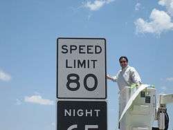
The stretch from Kerr County to El Paso County has an 80 mph (129 km/h) speed limit, which was the highest in the nation,[12] until the opening of the 85 mph (137 km/h) southern section of Texas State Highway 130 on October 24, 2012.[13]
San Antonio and Central Texas
I-10 is the busiest freeway in San Antonio with nearly 200,000 vehicles on an average day.[14] On the northwest side, I-10 is known as the McDermott Freeway, named after Robert F. McDermott, former dean of the United States Air Force Academy as well as CEO of San Antonio-based USAA. The highway enters the city concurrently with US 87 from the north and travels more in a north–south direction into downtown, rather than the east–west designation found on the Interstate Highway signs. The northern section from Loop 1604 to downtown serves one of the fastest growing areas of the city. A majority of the region's suburban office space is located along the corridor as are the headquarters for USAA, gasoline refiner and retailer Valero, South Texas Medical Center, the University of Texas at San Antonio (UTSA), Six Flags Fiesta Texas, and the Shops at La Cantera. I-10 intersects I-410 for the first time near Balcones Heights, a suburban city within San Antonio. The construction of a four-level interchange to accommodate the growing northwest side has been completed. Heavy commercial development dominates the landscape between I-410 and Loop 1604. Inside I-410, the route is lined with light industrial and residential areas.
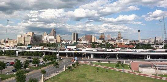
As I-10 heads south into downtown, it splits into an upper level with three lanes in each direction and a lower level with two lanes in each direction. It was necessary to design the freeway this way in order to accommodate the amount of traffic heading into downtown and to fit into the narrow corridor that was surrounded by existing infrastructure. I-10 meets I-35 on the northwest side of downtown and it overlaps I-35 south to form the west side of the downtown loop. The I-35 exit numbers are carried through during the concurrency. I-10 and I-35 end their concurrency at a four-level interchange on the southwest side of downtown with the junction of US 90 from the west. I-35 continues to the south and I-10 and US 90 run concurrently to the east to form the south side of the downtown loop. This section of I-10 is known as the Jose Lopez Freeway, named after the Medal of Honor recipient. A four-level interchange with I-37 occurs approximately two miles (3.2 km) east of the I-35 interchange. I-10 heads east away from downtown through mainly residential neighborhoods on the east side of San Antonio. I-10's concurrency with US 87 ends just east of downtown where US 87 heads south towards Victoria. I-10 provides access to the AT&T Center, home of the San Antonio Spurs and San Antonio Stars, and to the Freeman Coliseum, the current Stars home while AT&T Centre undergoes renovation. Leaving San Antonio, I-10 again passes I-410 and Loop 1604. I-10 is known as the 90th Infantry Division Memorial Highway on this stretch east of San Antonio. I-10 and US 90 continue their concurrency until they diverge in Seguin. They continue from there on to Houston nearly paralleling each other with short stints of overlaps along the route.
Houston and East Texas
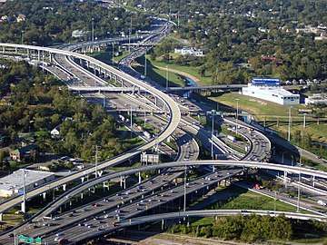
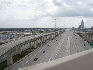
From the western suburb of Katy to downtown, I-10 is known as the Katy Freeway in Houston. This section was widened in 2008 to as many as 26 total lanes, counting the six lanes of the access road, which are not limited-access and therefore not technically part of the freeway itself but are directly adjacent.[15] Between the West Beltway and the West Loop, the minimum lane count is 22 total lanes. In this section, the width is 24 lanes at multiple locations and up to 26 lanes east of Gessner Road (12 main lanes, eight lanes of access roads, and six mid-freeway HOT/HOV lanes). From the Fort Bend county line to I-610, there is a minimum of four main lanes in each direction.[16] The maximum number of undivided lanes at any point on the freeway is nine in the eastbound direction approaching Antoine Drive (though this includes one exit-only lane); this is one of the widest sections of undivided highway in a single direction in the world.[17] The widest right-of-way, 556 ft (169 m), occurs at the Katy Freeway's intersection with Bunker Hill;[18] at that point, the expansion plans called for six main lanes plus two toll lanes in each direction along with 10 lanes on the feeder/frontage roads. The actual striping after construction delineates 29 lanes, including all 26 of the planned lanes plus an additional lane in each direction to enter or exit the toll lanes and one more turn lane on the eastbound feeder road.[19]
Between I-610 and I-45 west of downtown, the interstate contains at least five main lanes in each direction. Before 2008, this section had traditionally been the widest section of I-10 in the Houston area and the only one with a significant portion below grade. A project completed in 2014 added one extra auxiliary lane in each direction between Shepherd Drive and Taylor Street. In addition, the eastbound feeder road that ends at Studemont was extended to Taylor Street. As I-10 travels through downtown, it junctions with I-45 and I-69/US 59. Both interchanges feature left exits, allowing several lane shifts for through traffic. I-10 provides access to Minute Maid Park, home of the Houston Astros, and also runs through the campus of the University of Houston–Downtown.
The section east of downtown Houston is officially known as the "East Freeway", although it is widely known by locals as the Baytown East Freeway or colloquially shortened to the Beast, due to a marketing push by Baytown, one of the largest cities in the Greater Houston Area.
Exit list
| County | Location | mi | km | Exit | Destinations | Notes | ||
|---|---|---|---|---|---|---|---|---|
| El Paso | Anthony | 0.0 | 0.0 | New Mexico state line | ||||
| 0.01 | 0.016 | 0 | ||||||
| 0.7 | 1.1 | Tourist Info Center; exit 1 (eastbound) | ||||||
| 2.6 | 4.2 | 2 | ||||||
| El Paso | 4.9 | 7.9 | 5 | Check Station | ||||
| 5.9 | 9.5 | 6A | Signed as exit 6 eastbound | |||||
| 6.4 | 10.3 | 6B | Loop 375 exit 11B westbound to 10 westbound; westbound exit & eastbound entrance | |||||
| 7.6 | 12.2 | 8 | ||||||
| 8.7 | 14.0 | 9 | Redd Road | |||||
| 10.9 | 17.5 | 11 | ||||||
| 12.4 | 20.0 | 12 | Resler Drive | Westbound exit and eastbound entrance | ||||
| 13.1 | 21.1 | 13 | Eastern end of US 85 concurrency | |||||
| 15.9 | 25.6 | 16 | Executive Center Boulevard | |||||
| 17.9 | 28.8 | 18A | Schuster Avenue, University Avenue – U.T. El Paso | |||||
| 18.5 | 29.8 | 18B | Porfirio Díaz Street, Franklin Avenue | No westbound entrance | ||||
| 19.1 | 30.7 | 19A | Signed as exit 19 eastbound; eastbound traffic enter Downtown via Wyoming Avenue | |||||
| 20.0 | 32.2 | 19B | Downtown El Paso, Convention Center, Tourist Information, Arts District | Westbound exit only; downtown access via Missouri Avenue | ||||
| 20.4 | 32.8 | 20 | Dallas Street, Cotton Street | |||||
| 21.1 | 34.0 | 21 | Piedras Street | |||||
| 21.6 | 34.8 | 22A | ||||||
| 21.9 | 35.2 | 22B | US 54 exit 21; I-110 exit 21A | |||||
| 22.7 | 36.5 | 23A | Raynolds Street | |||||
| 23.3 | 37.5 | 23B | Eastern end of US 180 concurrency | |||||
| 23.9 | 38.5 | 24A | Trowbridge Drive | Westbound access is via exit 24 | ||||
| 24.2 | 38.9 | 24B | Geronimo Drive | Signed as exit 24 westbound | ||||
| 25.4 | 40.9 | 25 | ||||||
| 25.9 | 41.7 | 26 | Hawkins Boulevard | |||||
| 26.8 | 43.1 | 27 | Hunter Drive, Viscount Boulevard | Westbound access is via exit 28A | ||||
| 27.8 | 44.7 | 28A | Access to Del Sol Medical Center-East | |||||
| 28.8 | 46.3 | 28B | Yarbrough Drive, Sumac Drive | |||||
| 29.7 | 47.8 | 29 | Lomaland Drive | Westbound access is via exit 30 | ||||
| 30.1 | 48.4 | 30 | Lee Trevino Drive | |||||
| 31.6 | 50.9 | 32 | ||||||
| 33.1 | 53.3 | 33 | Don Haskins Drive | Westbound exit only | ||||
| 33.3– 33.5 | 53.6– 53.9 | 34A | Signed as exits 34A (TX Loop 375) and 34B (Americas Avenue, Joe Battle Boulevard) | |||||
| Socorro | 35.1 | 56.5 | 35 | Eastlake Boulevard | ||||
| Sparks | 37.0 | 59.5 | 37 | |||||
| Clint | 42.5 | 68.4 | 42 | |||||
| Fabens | 49.3 | 79.3 | 49 | |||||
| Tornillo | 55.4 | 89.2 | 55 | Tornillo | ||||
| Hudspeth | Fort Hancock | 68.1 | 109.6 | 68 | Acala Road | |||
| 72.3 | 116.4 | 72 | ||||||
| 78.4 | 126.2 | 78 | ||||||
| | 81.6 | 131.3 | 81 | |||||
| | 85.1 | 137.0 | 85 | Esperanza Road | ||||
| | 87.6 | 141.0 | 87 | |||||
| | 95.4 | 153.5 | 95 | Frontage Road | Eastbound exit and entrance | |||
| | 98.9 | 159.2 | 99 | Lasca Road | ||||
| Sierra Blanca | 105.6 | 169.9 | 105 | Signed as exit 106 westbound | ||||
| 106.9 | 172.0 | 107 | ||||||
| 108.5 | 174.6 | 108 | Westbound exit only | |||||
| Allamoore | 128.9 | 207.4 | 129 | Allamore | ||||
| | 132.7 | 213.6 | 133 | Frontage Road | Westbound exit and entrance | |||
| Culberson | Van Horn | 137.8 | 221.8 | 138 | ||||
| 139.7 | 224.8 | 140A | Access to Culberson County Airport | |||||
| 140.6 | 226.3 | 140B | ||||||
| Wild Horse | 146.3 | 235.4 | 146 | Wild Horse Road | ||||
| Michigan Flat | 152.9 | 246.1 | 153 | Michigan Flat | ||||
| Plateau | 159.4 | 256.5 | 159 | Plateau | ||||
| Boracho | 166.0 | 267.2 | 166 | Boracho Station | ||||
| | 172.6 | 277.8 | 173 | Hurds Draw Road | ||||
| Kent | 176.3 | 283.7 | 176 | |||||
| Jeff Davis | | 181.1 | 291.5 | 181 | Cherry Creek Road | |||
| | 183.6 | 295.5 | 184 | Springhills | ||||
| Reeves | | 186.2 | 299.7 | 186 | Westbound left exit and eastbound left entrance; provides access to I-10 east for travelers coming from I-20 west | |||
| | 186.8 | 300.6 | 187 | No eastbound entrance; left exit eastbound; no exit number eastbound; western terminus of I-20 | ||||
| | 187.6 | 301.9 | 188 | Giffin Road | ||||
| | 192.3 | 309.5 | 192 | |||||
| | 206.0 | 331.5 | 206 | |||||
| | 209.0 | 336.4 | 209 | Western end of SH 17 concurrency | ||||
| | 211.5 | 340.4 | 212 | Eastern end of SH 17 concurrency | ||||
| | 213.8 | 344.1 | 214 | Westbound exit and eastbound entrance | ||||
| | 221.7 | 356.8 | 222 | Hoefs Road | ||||
| Pecos | | 229.1 | 368.7 | 229 | Hovey Road | |||
| | 235.2 | 378.5 | 235 | Mendel Road | ||||
| | 240.8 | 387.5 | 241 | Kennedy Road | ||||
| | 245.9 | 395.7 | 246 | Firestone Road | ||||
| | 248.1 | 399.3 | 248 | Western end of US 67 concurrency | ||||
| | 252.3 | 406.0 | 253 | |||||
| Fort Stockton | 256.2 | 412.3 | 256 | |||||
| 257.0 | 413.6 | 257 | No westbound entrance, access to Fort Stockton-Pecos County Airport | |||||
| 258.5 | 416.0 | 259B | Signed as exit 259 eastbound, access to Pecos County Memorial Hospital | |||||
| 259.3 | 417.3 | 259A | Eastbound access is via exit 259 | |||||
| 260.8 | 419.7 | 261 | Western end of US 385 concurrency | |||||
| | 263.8 | 424.5 | 264 | Warnock Road | ||||
| | 271.5 | 436.9 | 272 | University Road | ||||
| | 272.6 | 438.7 | 273 | Eastern end of US 67/US 385 concurrency; no eastbound entrance | ||||
| | 276.6 | 445.1 | 277 | |||||
| | 284.4 | 457.7 | 285 | McKenzie Road | ||||
| | 287.5 | 462.7 | 288 | Ligon Road | ||||
| Bakersfield | 294.1 | 473.3 | 294 | |||||
| | 298.4 | 480.2 | 298 | |||||
| | 306.8 | 493.7 | 307 | |||||
| | 314.3 | 505.8 | 314 | Frontage Road | ||||
| | 319.9 | 514.8 | 320 | |||||
| | 324.8 | 522.7 | 325 | |||||
| Crockett | | 327.8 | 527.5 | 328 | River Road | |||
| | 336.7 | 541.9 | 337 | Live Oak Road | ||||
| | 343.1 | 552.2 | 343 | |||||
| | 349.5 | 562.5 | 350 | |||||
| | 360.8 | 580.7 | 361 | |||||
| Ozona | 363.4 | 584.8 | 363 | |||||
| 365.2 | 587.7 | 365 | Access to Ozona Municipal Airport | |||||
| 367.5 | 591.4 | 368 | ||||||
| | 371.8 | 598.4 | 372 | Taylor Box Road | ||||
| Sutton | | 380.9 | 613.0 | 381 | Eastbound exit and westbound entrance | |||
| | 387.3 | 623.3 | 388 | Westbound exit and eastbound entrance | ||||
| | 391.8 | 630.5 | 392 | |||||
| Sonora | 399.3 | 642.6 | 399 | Eastbound exit and westbound entrance | ||||
| 400.0 | 643.7 | 400 | Access to Sonora Municipal Airport | |||||
| | 403.8 | 649.9 | 404 | |||||
| | 411.8 | 662.7 | 412 | |||||
| | 420.0 | 675.9 | 420 | |||||
| | 428.4 | 689.4 | 429 | |||||
| Kimble | Roosevelt | 436.9 | 703.1 | 437 | Eastbound exit and westbound entrance | |||
| 438.2 | 705.2 | 438 | Westbound exit and eastbound entrance | |||||
| | 440.7 | 709.2 | 442 | |||||
| | 444.8 | 715.8 | 445 | Eastbound exit and westbound entrance | ||||
| | 451.1 | 726.0 | 451 | |||||
| Junction | 455.4 | 732.9 | 456 | Western end of US 83 concurrency, access to Kimble County Airport | ||||
| 457.3 | 736.0 | 457 | ||||||
| | 459.8 | 740.0 | 460 | Westbound exit and eastbound entrance | ||||
| | 461.5 | 742.7 | 462 | Eastern end of US 83 concurrency | ||||
| Segovia | 464.5 | 747.5 | 465 | |||||
| | 471.3 | 758.5 | 472 | |||||
| | 476.6 | 767.0 | 477 | |||||
| Kerr | | 483.9 | 778.8 | 484 | Midway Road | |||
| Mountain Home | 487.5 | 784.6 | 488 | |||||
| 489.8 | 788.3 | 490 | ||||||
| | 491.8 | 791.5 | 492 | |||||
| Gillespie |
No major junctions | |||||||
| Kerr | | 501.1 | 806.4 | 501 | ||||
| Kerrville | 504.8 | 812.4 | 505 | |||||
| 507.7 | 817.1 | 508 | access to Peterson Regional Medical Center, Kerrville VA Medical Center | |||||
| | 519.5 | 836.1 | 520 | |||||
| Kendall | Comfort | 522.4 | 840.7 | 523 | Western end of US 87 concurrency | |||
| 524.0 | 843.3 | 524 | ||||||
| | 526.6 | 847.5 | 527 | Eastbound access is via exit 524 | ||||
| Nelson City | 532.7 | 857.3 | 533 | |||||
| Boerne | 536.9 | 864.1 | 537 | Business Route | ||||
| 537.6 | 865.2 | 538 | Ranger Creek Road | Westbound exit and eastbound entrance | ||||
| 538.7 | 867.0 | 539 | Johns Road | |||||
| 540.1 | 869.2 | 540 | access to Boerne-Methodist Hospital | |||||
| 541.8 | 871.9 | 542 | Westbound exit and eastbound entrance | |||||
| 542.8 | 873.6 | 543 | Boerne Stage Road, Cascade Caverns Road | |||||
| Bexar | Fair Oaks Ranch | 544.6 | 876.4 | 545 | Balcones Creek Road, Dietz Elkhorn Road | Construction on a new interchange, scheduled for completion late 2018 | ||
| 546.1 | 878.9 | 546 | Fair Oaks Parkway / Tarpon Drive | |||||
| 548.2 | 882.2 | 548 | Old Fredericksburg Road / Buckskin Drive | Construction on a new interchange is scheduled to begin in late 2018 | ||||
| Leon Springs | 549.5 | 884.3 | 550 | |||||
| 550.6 | 886.1 | 551 | Boerne Stage Road – Leon Springs | Eastbound access is via exit 550 | ||||
| San Antonio | 552.9 | 889.8 | 552 | Dominion Drive | Westbound exit and entrance | |||
| 553.8 | 891.3 | 554 | Camp Bullis Road | |||||
| 553.9 | 891.4 | 555 | La Cantera Parkway – Fiesta Texas | |||||
| 555.3 | 893.7 | 556A | ||||||
| 555.8 | 894.5 | 556B | Access to Via Park and Ride | |||||
| 557.0 | 896.4 | 557 | UTSA Boulevard – University of Texas at San Antonio | Former Spur 53 | ||||
| 557.4 | 897.0 | 558 | De Zavala Road | |||||
| 558.3 | 898.5 | 559 | Eastbound exit and westbound entrance; access to South Texas Medical Center | |||||
| 559.0 | 899.6 | Woodstone Drive / De Zavala Road | No eastbound exit | |||||
| 558.9 | 899.5 | 560A | Westbound access is via exit 560; access to South Texas Medical Center | |||||
| 559.8 | 900.9 | 560B | Frontage Road | Eastbound exit and entrance | ||||
| 560.4 | 901.9 | 560 | Westbound exit and entrance; access to South Texas Medical Center | |||||
| 560.3 | 901.7 | 561 | Access to South Texas Medical Center | |||||
| 561.3 | 903.3 | 562 | Westbound access is via exit 561; access to South Texas Medical Center | |||||
| 562.7 | 905.6 | 563 | Callaghan Road | Eastbound access is via exit 562 | ||||
| Balcones Heights | 562.8 | 905.7 | 564 | I-410 exit 16; access to San Antonio International Airport | ||||
| 563.0 | 906.1 | 565A | Access to Methodist Texan Hospital | |||||
| San Antonio | 564.3 | 908.2 | 565B | Vance Jackson Road | ||||
| 565.2 | 909.6 | 566A | West Avenue | |||||
| 566.0 | 910.9 | 566B | Fresno Drive | |||||
| 566.2 | 911.2 | 566C | Hildebrand Avenue, Fulton Avenue | Signed as exit 567A westbound | ||||
| 567.3 | 913.0 | 567 | Signed as exit 567B westbound; westbound exit via lower level | |||||
| 568.1 | 914.3 | 568A | Cincinnati Avenue | Westbound exit via lower level and eastbound entrance via lower level | ||||
| 568.5 | 914.9 | 568B | Signed as exit 568 eastbound; access via upper level | |||||
| 568.7 | 915.2 | 569A | Colorado Street | Signed as exit 569 westbound; access via lower level; no eastbound entrance | ||||
| 569.0 | 915.7 | 569B | Frio Street – Downtown San Antonio | Eastbound exit via lower level and entrance via lower level | ||||
| 569.1 | 915.9 | 569C | Santa Rosa Street – Downtown San Antonio | Eastbound exit via upper level and westbound entrance via upper level | ||||
| 569.6 | 916.7 | 570 | Western end of I-35 concurrency; no exit number westbound (concurrent section uses I-35 exit numbers); I-35 exit 156 southbound | |||||
| See I-35 | ||||||||
| 572.2 | 920.9 | 572 | Western end of US 90 concurrency | |||||
| 572.4 | 921.2 | Eastern end of I-35 concurrency; exit 153 northbound | ||||||
| 573.0 | 922.2 | 573 | ||||||
| 574.1 | 923.9 | 574 | I-37 exit 139, access to San Antonio Amtrak Station | |||||
| 574.9 | 925.2 | 575 | Pine Street, Hackberry Street | |||||
| 575.1 | 925.5 | 576 | New Braunfels Avenue, Gevers Street | |||||
| 576.5 | 927.8 | 577 | Eastern end of US 87 concurrency | |||||
| 577.4 | 929.2 | 578 | Pecan Valley Drive, M. L. King Drive | |||||
| 578.5 | 931.0 | 579 | Houston Street, Commerce Street | |||||
| 579.6 | 932.8 | 580 | ||||||
| 580.4 | 934.1 | 581 | Western end of SH 130 concurrency; I-410 exit 33 | |||||
| 581.4 | 935.7 | 582 | Ackerman Road – Kirby | |||||
| 581.7 | 936.2 | 583 | Foster Road | |||||
| 582.6 | 937.6 | 584 | Woodlake Parkway | Construction on a new interchange, scheduled for completion in late 2019 | ||||
| 585.2 | 941.8 | 585 | ||||||
| 586.8 | 944.4 | 587 | ||||||
| 588.6 | 947.3 | 589 | Graytown Road, Pfeil Road | |||||
| 591.2 | 951.4 | 591 | ||||||
| | 593.1 | 954.5 | 593 | |||||
| Guadalupe | | 594.8 | 957.2 | 595 | Zuehl Road | |||
| | 596.7 | 960.3 | 597 | Santa Clara Road | ||||
| | 598.5 | 963.2 | 599 | |||||
| | 600.1 | 965.8 | 600 | Schwab Road | ||||
| | 601.0 | 967.2 | 601 | |||||
| | 602.9 | 970.3 | 603 | Eastern end of US 90 concurrency; eastbound exit and westbound entrance | ||||
| | 603.8 | 971.7 | 604 | |||||
| | 604.9 | 973.5 | 605 | |||||
| Seguin | 606.4 | 975.9 | 607 | |||||
| 608.3 | 979.0 | 609 | ||||||
| 609.5 | 980.9 | 610 | ||||||
| 611.5 | 984.1 | 612 | ||||||
| | 613.8 | 987.8 | 614 | Eastern end of SH 130 concurrency | ||||
| | 616.8 | 992.6 | 617 | |||||
| | 619 | Guadalupe County Safety Rest Area | Signed as exit 618 eastbound | |||||
| | 619.6 | 997.1 | 620 | |||||
| | 625.2 | 1,006.2 | 625 | Darst Field Road | ||||
| Luling | 627.4 | 1,009.7 | 628 | |||||
| Caldwell | | 631.6 | 1,016.5 | 632 | ||||
| Gonzales | | 636.8 | 1,024.8 | 637 | ||||
| | 642.3 | 1,033.7 | 642 | |||||
| | 649.0 | 1,044.5 | 649 | |||||
| | 652.4 | 1,049.9 | 653 | |||||
| Fayette | Flatonia | 661.2 | 1,064.1 | 661 | ||||
| | 667.6 | 1,074.4 | 668 | |||||
| Schulenburg | 673.6 | 1,084.1 | 674 | |||||
| | 676.9 | 1,089.4 | 677 | |||||
| Colorado | Weimar | 681.4 | 1,096.6 | 682 | ||||
| | 689.1 | 1,109.0 | 689 | |||||
| | 692 | Colorado County Safety Rest Area | ||||||
| | 692.5 | 1,114.5 | 693 | |||||
| Columbus | 693.8 | 1,116.6 | 695 | Western end of SH 71 concurrency; no eastbound exit | ||||
| 695.6 | 1,119.5 | 696 | Eastern end of SH 71 concurrency | |||||
| | 698.1 | 1,123.5 | 698 | Western end of US 90 concurrency | ||||
| | 699.4 | 1,125.6 | 699 | |||||
| | 703.5 | 1,132.2 | 704 | |||||
| | 708.9 | 1,140.9 | 709 | |||||
| Austin | | 711.3 | 1,144.7 | 713 | Beckendorff Road | |||
| | 715.5 | 1,151.5 | 716 | Pyka Road | ||||
| Sealy | 717.5 | 1,154.7 | 718 | Eastern end of US 90 concurrency | ||||
| 719.3 | 1,157.6 | 720 | ||||||
| 720.2 | 1,159.0 | 720A | Outlet Center Drive | Eastbound exit only | ||||
| 721.5 | 1,161.1 | 721 | Western end of US 90 concurrency; westbound exit and eastbound entrance | |||||
| San Felipe | 722.2 | 1,162.3 | 723 | |||||
| | 724.7 | 1,166.3 | 725 | Mlcak Road | Eastbound access is via exit 723 | |||
| | 725.4 | 1,167.4 | 726 | Chew Road | Eastbound exit and westbound entrance | |||
| Waller | | 727.8 | 1,171.3 | 729 | Peach Ridge Road, Donigan Road (US 90 east) | Eastern end of US 90 concurrency; signed as exit 730 westbound | ||
| Brookshire | 731.1 | 1,176.6 | 731 | |||||
| 731.9 | 1,177.9 | 732 | ||||||
| | 733.9 | 1,181.1 | 734 | Woods Road | ||||
| | 735.0 | 1,182.9 | 735 | Igloo Road, Jordan Ranch Blvd | No westbound entrance | |||
| | 736.1 | 1,184.6 | 737 | Pederson Road | ||||
| | 738.4 | 1,188.3 | 739 | Cane Island Parkway | ||||
| Fort Bend | Katy | 739.1 | 1,189.5 | 740 | No eastbound exit | |||
| 739.8 | 1,190.6 | 741 | Pin Oak Road | Westbound access is via exit 740 | ||||
| Harris | 741.1 | 1,192.7 | Western end of US 90 concurrency; westbound exit and eastbound entrance | |||||
| 741.5 | 1,193.3 | 742 | Katy-Fort Bend County Road | Eastbound access is via exit 741 | ||||
| 741.8 | 1,193.8 | 743A | Signed as exit 743 westbound; access to Memorial Hermann Katy Hospital | |||||
| 742.3 | 1,194.6 | 743B | ||||||
| 743.2 | 1,196.1 | 745 | Mason Road | |||||
| 744.6 | 1,198.3 | 746 | Westgreen Boulevard | |||||
| 745.5 | 1,199.8 | 747A | Fry Road | |||||
| 746.5 | 1,201.4 | 747B | Greenhouse Road | |||||
| Houston | 747.3 | 1,202.7 | 748 | Access to West Houston Airport and Methodist West Houston Hospital | ||||
| 748.6 | 1,204.8 | 750 | Park Ten Boulevard | |||||
| 749.8 | 1,206.7 | 751 | ||||||
| 750.6 | 1,208.0 | I-10 Toll lanes (Katy Tollway) | West end of Katy Tollway | |||||
| 751.4 | 1,209.3 | — | Addicks Park & Ride | Interchange for Katy Tollway only | ||||
| 751.1 | 1,208.8 | 753A | Eldridge Parkway | |||||
| 752.6 | 1,211.2 | 753B | Dairy Ashford Road | |||||
| 753.3 | 1,212.3 | 754 | Kirkwood Road | |||||
| 754.3 | 1,213.9 | 755 | Wilcrest Drive | |||||
| 755.8 | 1,216.3 | 756A | Eastbound access is via exit 755 | |||||
| 755.1 | 1,215.2 | 756B | Signed as exit 756 eastbound | |||||
| 755.9 | 1,216.5 | 757 | Access to Memorial Hermann Memorial City Medical Center | |||||
| 757.2 | 1,218.6 | 758 | Bunker Hill Road | |||||
| 757.9 | 1,219.7 | 759A | Blalock Road, Echo Lane | Signed as exit 759 eastbound | ||||
| 758.7 | 1,221.0 | 759B | Campbell Road | Eastbound access is via exit 759 | ||||
| 758.8 | 1,221.2 | 760 | Bingle Road, Voss Road | |||||
| 759.7 | 1,222.6 | 761A | Wirt Road, Chimney Rock Road | Signed as exit 761 eastbound | ||||
| 761.0 | 1,224.7 | 761B | Antoine Drive, Silber Road | Eastbound access is via exit 761 | ||||
| 760.7 | 1,224.2 | — | North Post Oak Road – NW Transit Center | Eastbound exit only for Katy Tollway | ||||
| 761.5 | 1,225.5 | I-10 Toll lanes (Katy Tollway) | East end of Katy Tollway | |||||
| 761.0 | 1,224.7 | 762 | Silber Road, North Post Oak Road, Katy Road | Signed as exit 762B westbound; Katy Road not signed eastbound | ||||
| 762.0 | 1,226.3 | 763 | I-610 exit 11; entrance from I-610 south includes direct entrance ramp from US 290 (Northwest Freeway) | |||||
| 762.8 | 1,227.6 | — | HOV/toll exit; westbound exit and eastbound entrance | |||||
| 763.5 | 1,228.7 | 764 | Washington Avenue, Westcott Street | |||||
| 764.3 | 1,230.0 | 765A | T. C. Jester Boulevard | |||||
| 764.6 | 1,230.5 | 765B | Durham Drive, Shepherd Drive, Patterson Street | |||||
| 765.3 | 1,231.6 | 766 | Yale Street, Heights Boulevard | |||||
| 765.8 | 1,232.4 | 767A | Studemont Drive | Eastbound exit and westbound entrance | ||||
| 766.5 | 1,233.6 | 767B | Taylor Street | |||||
| 767.3– 767.7 | 1,234.8– 1,235.5 | 768 | Signed as exits 768A (north) and 768B (south); left exits eastbound; I-45 exits 48A-B | |||||
| 768.1 | 1,236.1 | 769A | Eastbound exit and westbound entrance, access to Houston Amtrak station | |||||
| 768.5 | 1,236.8 | 769B | Westbound exit and eastbound entrance, access to Houston Amtrak station | |||||
| 768.6 | 1,236.9 | 769C | McKee Street, Hardy Street | Eastbound exit and westbound entrance | ||||
| 769.1– 769.4 | 1,237.7– 1,238.2 | 770 | I-69/US 59 exit 132; signed as exits 770A (south) & 770C (north). | |||||
| 769.3 | 1,238.1 | 770B | Jensen Drive, Meadow Street, Gregg Street | |||||
| 770.4 | 1,239.8 | 771A | Waco Street | |||||
| 770.9 | 1,240.6 | 771B | Lockwood Drive | |||||
| 771.5 | 1,241.6 | 772 | Kress Street, Lathrop Street | |||||
| 772.5 | 1,243.2 | 773A | ||||||
| 772.9 | 1,243.9 | 773B | McCarty Drive | |||||
| 773.7 | 1,245.1 | 774 | Gellhorn Drive | Eastbound exit and westbound entrance | ||||
| 773.9 | 1,245.5 | 775A | I-610 exit 26 | |||||
| 774.1 | 1,245.8 | 775B | Eastern end of US 90 concurrency; eastbound exit and westbound entrance | |||||
| 775.1 | 1,247.4 | 776A | Mercury Drive - Jacinto City, Galena Park | |||||
| 775.5 | 1,248.0 | 776B | John Ralston Road, Holland Avenue | |||||
| 776.4 | 1,249.5 | 778A | Westbound access is via exit 778 | |||||
| 777.6 | 1,251.4 | 778B | Normandy Street | Signed as exit 778 westbound | ||||
| 778.5 | 1,252.9 | 779A | Westmont Street | Westbound exit only | ||||
| 778.6 | 1,253.0 | 779B | Signed as exit 780 eastbound; access to East Houston Regional Medical Center | |||||
| Channelview | 779.6 | 1,254.6 | 780 | Freeport Street | Eastbound access is via exit 779B | |||
| 780.1 | 1,255.4 | 781A | Eastbound exit and westbound entrance | |||||
| 780.5 | 1,256.1 | 781 | Signed as exit 781B eastbound, 781A westbound | |||||
| 781.3 | 1,257.4 | 781B | Market Street | Westbound exit only | ||||
| 781.2 | 1,257.2 | 782 | Dell Dale Avenue | No westbound entrance | ||||
| 782.2 | 1,258.8 | 783 | Sheldon Road | |||||
| 783.1 | 1,260.3 | 784 | Cedar Lane, Bayou Drive | |||||
| 784.4 | 1,262.4 | 785 | Magnolia Avenue | |||||
| 785.5 | 1,264.1 | 786 | Monmouth Drive | |||||
| Baytown | 787.0 | 1,266.6 | 787 | Crosby-Lynchburg Road | ||||
| 787.5 | 1,267.4 | 788 | Westbound access is via exit 787 | |||||
| 788.5 | 1,269.0 | 789 | Thompson Road | |||||
| 789.2 | 1,270.1 | 790 | Ellis School Road | Westbound exit only | ||||
| 789.9 | 1,271.2 | 790 | Wade Road | Westbound access is via exit 791 | ||||
| 790.6 | 1,272.3 | 791 | John Martin Road | |||||
| 791.5 | 1,273.8 | 792 | Access to San Jacinto Methodist Hospital | |||||
| 792.6 | 1,275.6 | 793 | North Main Street | |||||
| 794.1 | 1,278.0 | 795 | Sjolander Road | |||||
| 795.2 | 1,279.8 | 796 | Frontage Road | Signed as exit 796B westbound | ||||
| Chambers | Mont Belvieu | 796.7 | 1,282.2 | 798 | Signed as exit 797 eastbound | |||
| 798.6 | 1,285.2 | 799 | ||||||
| 799.9 | 1,287.3 | 800 | ||||||
| Cove | 802.4 | 1,291.3 | 803 | |||||
| | 804.6 | 1,294.9 | 805 | Trinity River Boat Ramp Turnaround | Eastbound exit and westbound entrance | |||
| | 805.7 | 1,296.6 | 806 | Frontage Road | Westbound entrance only | |||
| | 806.4 | 1,297.8 | 807 | Wallisville | ||||
| | 809.0 | 1,302.0 | 810 | |||||
| | 810.6 | 1,304.5 | 811 | Turtle Bayou Turnaround | Eastbound exit only | |||
| | 811.2 | 1,305.5 | 813 | Signed as exit 812 eastbound | ||||
| | 814.0 | 1,310.0 | 815 | Frontage Road, Wallace Road - Rest Area | Signed as exit 814 eastbound; Rest areas off each direction's respective Frontage Road | |||
| | 816.0 | 1,313.2 | 817 | |||||
| | 818.3 | 1,316.9 | 819 | Jenkins Road | ||||
| | 821.8 | 1,322.6 | 822 | |||||
| Winnie | 826.5 | 1,330.1 | 827 | |||||
| 827.4 | 1,331.6 | 828 | Eastbound exit and westbound entrance | |||||
| 827.9 | 1,332.4 | 829 | ||||||
| Jefferson | | 832.3 | 1,339.5 | 833 | Hamshire Road | |||
| | 837.7 | 1,348.1 | 838 | |||||
| | 842.8 | 1,356.4 | 843 | Smith Road | ||||
| Beaumont | 844.4 | 1,358.9 | 845 | Westbound access is via exit 847 | ||||
| 846.1 | 1,361.7 | 847 | Brooks Road | Eastbound access is via exit 845 | ||||
| 847.5 | 1,363.9 | 848 | Walden Road | |||||
| 848.6 | 1,365.7 | 849 | Western end of US 69/US 96/US 287 concurrency; access to Jack Brooks Regional Airport | |||||
| 849.5 | 1,367.1 | 850 | Washington Boulevard | Eastbound access is via exit 849 | ||||
| 850.1 | 1,368.1 | 851 | Access to Memorial Hermann Baptist Beaumont Hospital | |||||
| 851.5 | 1,370.4 | 852A | Laurel Avenue | Westbound exit and eastbound entrance | ||||
| 850.5 | 1,368.7 | 852B | Calder Avenue, Harrison Avenue, Gladys Avenue | |||||
| 851.7 | 1,370.7 | 853A | Eastern end of US 69/US 96/US 287 concurrency | |||||
| 852.2 | 1,371.5 | 853B | 11th Street | |||||
| 852.9 | 1,372.6 | 853C | 7th Street | Eastbound exit and westbound entrance | ||||
| 853.4 | 1,373.4 | 854 | ||||||
| 854.2 | 1,374.7 | 855A | Western end of US 90 concurrency | |||||
| 854.3 | 1,374.9 | 855B | Magnolia Avenue, Pine Street | Eastbound access is via exit 854 | ||||
| Orange | | 855.3 | 1,376.5 | 856 | Old Highway 90 – Rose City | Eastbound exit and westbound entrance | ||
| Rose City | 857.3 | 1,379.7 | 858 | Asher Turnaround – Rose City | ||||
| 858.3 | 1,381.3 | 859 | Dewitt Road, Bonner Turnaround, Asher Turnaround | |||||
| Vidor | 859.5 | 1,383.2 | 860 | Westbound access is via exit 861 | ||||
| 860.4 | 1,384.7 | 861 | Tram Road, Old Highway | Westbound access is via exit 862B | ||||
| 860.6 | 1,385.0 | 861A | Westbound exit signed as exit 862B | |||||
| 861.8 | 1,386.9 | 862A | Timberlane Drive, Lakeside Street | Eastbound exit only | ||||
| 863.2 | 1,389.2 | 864 | ||||||
| 864.6 | 1,391.4 | 865 | Doty Road | Westbound exit only | ||||
| 866.5 | 1,394.5 | 867 | Frontage Road | Eastbound exit only | ||||
| | 867.7 | 1,396.4 | 869 | |||||
| | 869.2 | 1,398.8 | 870 | |||||
| | 871.3 | 1,402.2 | 872 | North Mimosa Lane, Jackson Drive | Westbound exit only | |||
| Orange | 871.8 | 1,403.0 | 873 | |||||
| 872.4 | 1,404.0 | 874A | Eastbound exit and westbound entrance; eastbound entrance is via Womack Road | |||||
| 873.5 | 1,405.8 | 874 | Westbound exit signed as exit 875; access to Memorial Hermann Baptist Orange Hospital | |||||
| 873.3 | 1,405.4 | 875 | Womack Road | Westbound exit and eastbound entrance; separate exit from FM 3247 | ||||
| 874.7 | 1,407.7 | Woodlark Street | Eastbound exit only; separate exit from FM 3247 | |||||
| 875.6 | 1,409.1 | 876 | Adams Bayou | Westbound exit only | ||||
| 875.8 | 1,409.5 | 877 | No westbound exit (closed until March 2019) | |||||
| 877.1 | 1,411.6 | 878 | ||||||
| 878.7 | 1,414.1 | 879 | Texas Travel Information Center | Eastbound access is via exit 880 | ||||
| 879.0 | 1,414.6 | 880 | Sabine River Turnaround | Eastbound exit and westbound entrance | ||||
| 879.6 | 1,415.6 | Louisiana state line | ||||||
1.000 mi = 1.609 km; 1.000 km = 0.621 mi
| ||||||||
Related highways
I-10 has four business loops within the state. All of these routes are in the far western Trans-Pecos region. These routes are located along the former routes of US 80 and US 290 and include Bus. I-10-C in Sierra Blanca, Bus. I-10-D in Van Horn, Bus. I-10-F in Balmorhea, and Bus. I-10-G in Fort Stockton.
I-10 has three auxiliary routes in Texas:


See also


Notes
- ↑ The certified mileage given is shorter than the actual mileage as TxDOT considers I-10 to be discontinuous at rather than concurrent with I-35 in San Antonio.
References
- ↑ Transportation Planning and Programming Division (n.d.). "Interstate Highway No. 10". Highway Designation Files. Texas Department of Transportation. Retrieved September 21, 2006.
- ↑ Texas Advisory Committee (August 2011). Human Trafficking in Texas: More Resources and Resolve Needed to Stem Surge of Modern Day Slavery (Report). United States Commission on Civil Rights. p. 4. Retrieved September 13, 2018.
- ↑ Christian, Carol (May 13, 2015). "Bragging rights or embarrassment? Katy Freeway at Beltway 8 is world's widest". Houston Chronicle. Hearst. Retrieved January 4, 2016. . Note that China has a 50-lane toll plaza approach on a freeway.
- ↑ Transportation Planning and Programming Division (n.d.). "U.S. Highway No. 80". Highway Designation Files. Texas Department of Transportation. Retrieved September 21, 2006.
- ↑ Transportation Planning and Programming Division (n.d.). "U.S. Highway No. 290". Highway Designation Files. Texas Department of Transportation. Retrieved September 21, 2006.
- ↑ Purcell, Brian (December 6, 2010). "San Antonio Freeway System: History". The Texas Highway Man Pages. Retrieved July 13, 2013.
- ↑ "24 Hour Saturation Counts". H-GAC Transportation Department. Archived from the original on August 8, 2006. Retrieved September 20, 2006.
- ↑ "Governor Perry and Rep. Culberson Join TxDOT for Katy Frwy Ribbon Cutting" (Press release). Katy Freeway Public Information Office. June 26, 2006. Retrieved September 20, 2006.
- ↑ "Toll Road Info". Harris County Toll Road Authority. Retrieved October 2, 2012.
- ↑ Manning, Johnathan (March 10, 2016). "Water Rages from Toledo Bend Dam at Record Pace". Lake Charles, LA: KPLC-TV. Retrieved August 26, 2016.
- ↑ Wells, Carlie Kollath (March 19, 2016). "I-10 Closed at Texas–Louisiana Line for 4th Day Due to Flooding". The Times-Picayune. New Orleans. Retrieved August 26, 2016.
- ↑ Fernandez, Manny (September 10, 2012). "Reclaiming the Title of Fastest in the Land". The New York Times. Retrieved June 6, 2015.
- ↑ "85 MPH! Texas to Open Tollway with Fastest Speed Limit in Nation". NBC News. September 6, 2012. Retrieved June 6, 2015.
- ↑ 2004 San Antonio District Traffic Map (PDF) (Map). Texas Department of Transportation. 2004.
- ↑ Schematic Layout: IH 10 Katy Frwy, IH 10 at Bunker Hill Road (PDF) (Map). Texas Department of Transportation. Archived from the original (PDF) on December 9, 2014.
- ↑ "Lane Configurations". Katy Freeway. Texas Department of Transportation. Archived from the original on April 7, 2014.
- ↑ Google (September 21, 2006). "Interstate 10 lanes at Antoine Drive" (Map). Google Maps. Google. Retrieved September 21, 2006.
- ↑ Slotboom, Erik (2003). Houston Freeways: A Historical and Visual Journey (PDF). [S.l.]: O.F. Slotboom. p. 214. ISBN 978-0974160535.
- ↑ Microsoft; Nokia (January 20, 2015). "9669 I-10, Houston, TX 77024" (Map). Bing Maps. Microsoft. Retrieved January 20, 2015.
External links
| Wikimedia Commons has media related to Interstate 10 in Texas. |
Route map:
| Previous state: New Mexico |
Texas | Next state: Louisiana |