Galveston Bay
| Galveston Bay | |
|---|---|
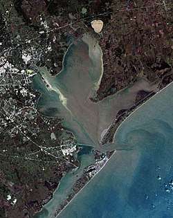 Satellite image of Galveston Bay. Galveston Island is at the bottom of the image, separated from Bolivar Peninsula by Bolivar Roads. A portion of Greater Houston is visible to the left. | |
| Location |
|
| Coordinates | 29°34′11″N 94°56′12″W / 29.56972°N 94.93667°WCoordinates: 29°34′11″N 94°56′12″W / 29.56972°N 94.93667°W |
| Primary inflows | Trinity River, San Jacinto River |
| Ocean/sea sources | Gulf of Mexico |
| Basin countries |
|
| Max. length | 30 miles (48 km) |
| Max. width | 17 miles (27 km) |
| Surface area | 600 square miles (1,600 km2) |
| Average depth | 6 feet (1.8 m) |
| Max. depth | 10 feet (3.0 m) |
| Settlements | Texas City, Kemah, Seabrook, La Porte, Baytown, Anahuac |
Galveston Bay (/ˈɡælvɪstən/ GAL-vis-tən) is the seventh largest[1] estuary in the United States, located along the upper coast of Texas. It is connected to the Gulf of Mexico and is surrounded by sub-tropic marshes and prairies on the mainland.[2] The water in the bay is a complex mixture of sea water and fresh water which supports a wide variety of marine life. At an average depth of only 6 feet (1.8 m) it is unusually shallow for its size.
The bay has played a significant role in the history of Texas. Galveston Island is home to the city of Galveston, the earliest major settlement in southeastern Texas and the state's largest city toward the end of the 19th century.[3] While a devastating hurricane in 1900 hastened Galveston's decline, the subsequent rise of Houston as a major trade center, facilitated by the dredging of the Houston Ship Channel across the western half of the bay, ensured the bay's continued economic importance.[4]
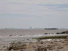
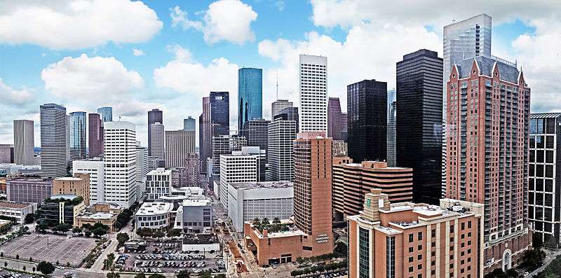
Today, Galveston Bay is encompassed by Greater Houston. With a population of over 6.6 million, Greater Houston is the fifth largest metropolitan area in the United States.[5] The Port of Houston, which has facilities spread across the northwestern section of the bay, is the second-busiest port in the nation by overall tonnage.[6] Other major ports utilizing the bay include the Port of Texas City and the Port of Galveston. With its diverse marine life, Galveston Bay also produces more seafood than any bay in the nation except the Chesapeake.[7]
History
The Gulf Coast gained its present configuration during the most recent glacial period approximately 18 ka (thousands of years ago). Low global sea levels allowed the Texas mainland to extend significantly further south than it is presently, and the Trinity River had carved a 170-foot (52 m) deep canyon through present-day Bolivar Roads on its way to the coast.[8] As the glacial period came to a close, rising sea levels initially filled this narrow canyon, followed by the broad lowlands of present-day Trinity Bay. Rapid sea level rise between 7.7 and 5.5 ka shifted the Gulf coastline northward to its contemporary latitude.[8] This was quickly followed by the formation of Galveston Island (5.5 ka), a barrier island, and Bolivar Peninsula (2.5 ka), which began as a spit.[8]
Human settlement in what is now Texas began at least 10,000 years ago following migrations into the Americas from Asia during the last ice age.[9] The first substantial settlements in the area are believed to have been the Karankawa and Atakapan tribes, who lived throughout the Gulf coast region.[10][11]
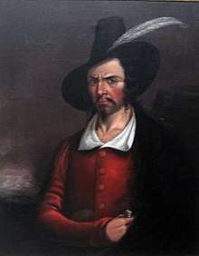
Though several Spanish expeditions charted the Gulf Coast, it was explorer José Antonio de Evia who in 1785 gave the bay and the island the name Galvezton in honor of Spanish viceroy Bernardo de Gálvez.[12] Louis Aury established a naval base at the harbor in 1816 to support the Mexican War of Independence. His base was soon appropriated by pirate Jean Lafitte, who temporarily transformed Galveston Island and the bay into a haven for outlaws before being ousted by the United States Navy.[13]
Following its independence from Spain, the new nation of Mexico claimed Texas as part of its territory. Settlements were established around the bay, including Galveston, Anahuac, Lynchburg, and San Jacinto. Following growing unrest, Texas revolted and gained independence in 1836 at the Battle of San Jacinto, near the bay along the San Jacinto River. The new Republic of Texas grew rapidly and joined the United States in 1845.
After the election of Abraham Lincoln in 1860, residents of Galveston strongly supported secession and sided with the Confederacy as the Civil War broke out.[14] However, separation from the Union did not last long; the city's harbor was blockaded by the federal navy starting in July 1861, followed by a full-scale occupation after the Battle of Galveston Harbor in October 1862.[14] However, at the Battle of Galveston in January 1863, a small Confederate force managed to overwhelm the Union's naval forces in the bay and retake the island.[15] Despite this victory, the Union continued to blockade the outlets of Galveston Bay until the end of the war.[14]
Reconstruction was swift in southeast Texas. Ranching interests were major economic drivers on the mainland in the 19th century. The city of Galveston became a major U.S. commercial center for shipping cotton, leather products and cattle, and other goods produced in the growing state. Railroads were built around the shore and new communities continued to emerge.[16] Commercial fishing developed as a substantial industry, particularly oysters, finfish, and later, shrimp.
The Galveston Hurricane of 1900 devastated the city of Galveston and heavily damaged communities around the bay.[17] Growth moved inland to Houston as fear of the risks posed by establishing businesses at Galveston limited the island's ability to compete. Texas City emerged as another important port in the area. Shipping traffic through the bay expanded dramatically after the federal government completed the dredging of the Houston Ship Channel to a depth of 25 feet (7.6 m) in 1914.[18] By the end of the 1930s, the Port of Houston was the largest cotton port and third largest port by overall tonnage in the United States.[18]
The Texas oil boom began in 1901 and by 1915 oil production by the bay was fully underway. Oil wells and refineries quickly developed throughout the area.[19][18]
Industrialization and urbanization led to pollution of the bay. By the 1970s, the bay was described by U.S. Representative Robert C. Eckhardt as "the most polluted body of water in the U.S."[20] The ship channel and Clear Lake were rated by the Galveston Bay National Estuary Program as having even worse water quality.[20] Drilling for oil and groundwater, as well as large wakes from increasing shipping in the bay, led to land subsidence and erosion along the shoreline, especially in the Baytown–Pasadena area.[21] Over the past few decades, approximately 100 acres (0.40 km2) of the historic San Jacinto battleground has been submerged, Sylvan Beach, a popular destination in La Porte, has been severely eroded, and the once prominent Brownwood neighborhood of Baytown has been abandoned.[22]
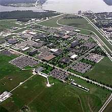
The establishment of NASA's Johnson Space Center near the bay in the Clear Lake Area in 1963 brought new growth. By the 1970s, Houston had become one the nation's largest cities, and its expansion connected it with the bay communities. The bay's shoreline became heavily urbanized.[23] Today, the bay is a major destination for recreational and tourist activities, including boating, ecotourism, and waterfowl hunting.[24]
Hurricane Ike, the most economically and environmentally destructive event on the bay since 1900, struck in 2008.[25] A proposal to build a flood barrier system to prevent against future storm surge, the Ike Dike, is being considered by the state government.[26]
Geography
Galveston Bay covers approximately 600 square miles (1,600 km2), and is 30 miles (48 km) long and 17 miles (27 km) wide.[27] The bay has an average depth of 6 feet (1.8 m) and a maximum undredged depth of 10 feet (3.0 m).[27] The Galveston Bay system consists of four main sub-bays: Galveston Bay proper (upper and lower), Trinity Bay, East Bay, and West Bay.[28] At Galveston Pier the maximum recorded tidal range was 3 feet (0.91 m), over the course of a month (August 2017) the range was 1.9 feet (0.58 m).[29]
A majority (54%) of the bay's inflow comes from the Trinity River, which contributes 7.5 million acre feet (9.3×10⁹ m3) of freshwater annually.[1][27] The San Jacinto River, accounting for 28% of inflow volume, contributes another 500,000 acre feet (620,000,000 m3).[1][27] Local watersheds contribute the remaining 18%.[27]
Galveston Bay has three outlets to the Gulf of Mexico: Bolivar Roads (the exit of the Houston Ship Channel) between Galveston Island and the Bolivar Peninsula, San Luis Pass at the west end of Galveston Island, and Rollover Pass across Bolivar Peninsula. Many smaller bays and lakes are connected to the main system, including Christmas Bay, Moses Lake, Dickinson Bay, Clear Lake, Ash Lake, Black Duck Bay, and San Jacinto Bay.
The Gulf Intracoastal Waterway, an inland waterway consisting of natural islands and man-made canals, runs between the bay and the Gulf.
Climate
The climate around the Bay is classified as humid subtropical (Cfa in Köppen climate classification system).[30] Prevailing winds from the south and southeast bring heat from the deserts of Mexico and moisture from the Gulf of Mexico.[31]
Summer temperatures regularly exceed 90 °F (32 °C) and the area's humidity drives the heat index even higher.[32] Winters in the area are temperate with typical January highs above 60 °F (16 °C) and lows are near 40 °F (4 °C). Snowfall is generally rare. Annual rainfall averages well over 40 inches (1,000 mm) a year with some areas typically receiving over 50 inches (1,300 mm).[33]
Hurricanes are an ever-present threat during the fall season. Galveston Island and the Bolivar Peninsula are generally at the greatest risk. However, though the island and the peninsula provide some shielding,[34] the bay shoreline still faces significant danger from storm surge.[35]
Ecosystem
This unique and complex mixing of waters from different sources provides nursery and spawning grounds for many types of marine life including crabs, shrimp, oysters, and many varieties of fish thereby supporting a substantial fishing industry.[7] The deeper navigation channels of the bay provide suitable habitats for bottlenose dolphins, which feed on the abundant fish varieties.[36] Additionally, the system of bayous, rivers, and marshes that rings the bay supports its own collection of ecosystems, containing diverse wildlife and enabling freshwater farming of crawfish.[37]
The wetlands that surround the bay support a variety of fauna. Notable terrestrial species include the American alligator and the bobcat, while bird species include the yellow rail, purple gallinule, and pelican.[38]
Pollution
The Houston Area Research Council (HARC) and Galveston Bay Foundation periodically release the Galveston Bay Report Card, which grades a number of metrics indicative of the health of the bay's ecosystem and waters. The 2016 reports assigns a "C" grade for toxins in bay sediments, noting high concentrations of mercury and pyrene.[39] The presence of the San Jacinto Pits Superfund site in the Houston Ship Channel, which contains large amounts of dioxin, is considered a significant threat to the bay's health.[39]
The entire bay is covered by seafood consumption advisories set by the Texas Department of State Health Services, but the strictness of these standards varies by location. In the Ship Channel, advisories recommend against the consumption of all fish and blue crab, while in the lower bay, advisories only apply to catfish.[39]
In the early 1990s, the Houston Ship Channel had the fifth highest level of toxic chemicals in the nation due to industrial discharge, with over 18.2 million pounds (8,300,000 kg) discharged between 1990 and 1994.[40] However, the bay has generally benefitted from improving water quality since the passage of the Clean Water Act in 1972.[39]
Excessive ozone levels can occur due to industrial activities; nearby Houston is ranked among the most ozone-polluted cities in the United States.[41] The industries located along the ship channel are a major cause of the pollution.[42]
On March 22, 2014, a barge carrying nearly 1 million US gallons (3.8×10⁶ L) of marine fuel oil collided with another ship in the Houston Ship Channel, causing the contents of one of the barge's 168,000-US-gallon (640,000 L) tanks to leak into Galveston Bay.[43]
Urban development
Galveston Bay is located in Greater Houston, which is the fifth largest metropolitan area in the United States, and home to one of the nation's most significant shipping centers.[44] Houston, the nation's fourth largest city, is the economic and cultural center of the region. Other significant communities bordering the bay include Texas City, Pasadena, Baytown, Seabrook, Kemah, Clear Lake, and Anahuac. The bay is bordered by four counties: Brazoria, Chambers, Harris, and Galveston.
Important ports that serve the bay include the Port of Houston, the Port of Texas City, and the Port of Galveston. The Houston Ship Channel, which connects the Port of Houston to the Gulf, passes through the bay. It is a partially man-made feature created by dredging the Buffalo Bayou, the ship channel subbays, and Galveston Bay.[45]
The area has a broad industrial base including the energy, manufacturing, aeronautics, transportation, and health care sectors. The bayside communities in particular are home to the Johnson Space Center, which houses the Christopher C. Kraft Jr. Mission Control Center, Ellington Field Joint Reserve Base, Ellington Airport (home of the Houston Spaceport), and a high concentration of petrochemical refineries.[46]
Economy
A large commercial fishing industry has grown around Galveston Bay, with significant production of shrimp, blue crab, eastern oyster, black drum, flounder, sheepshead, and snapper.[47] In 2007, the Port of Galveston produced 19.2 million pounds (8.7×10⁶ kg) of seafood with a value of $40.1 million.[48]
Galveston Bay supports a significant recreation and tourism industry, especially as a result of its proximity to major population centers. Over 40% of Greater Houston residents participate annually in hiking and swimming along the bay, while 20% go fishing and 15% go boating.[24] The five counties surrounding the bay are home to 88,000 registered pleasure crafts.[24] Fishing expenditures (such as the purchase of fishing bait or lodging) along Galveston Bay and Sabine Lake generate approximately $650 million annually.[48] The recreational fishing industry supports over 3,000 jobs in the bay area.[48]
With over 600 species of birds, Galveston Bay is a popular destination for birdwatching. This sort of ecotourism generates millions in annual revenue for Chambers County, which is home to the Anahuac National Wildlife Refuge and High Island.[24]
See also
Notes
- 1 2 3 Pulich, Jr., Warren (2002). "Seagrass Status and Trends in the Northern Gulf of Mexico: Galveston Bay System" (PDF). United States Geological Survey. Retrieved 2017-03-29.
- ↑ Eubanks (2006), pg. 10–11
- ↑ McComb, David G. (2010-06-15). "Galveston, TX". Texas State Historical Association. Retrieved 2017-03-28.
- ↑ "J.H.W. Stele to Sayers, September 11–12, 1900". Texas State Library and Archives Commission, Retrieved on August 31, 2007
- ↑ Lawhorn, Valerie (2016-03-24). "Census Numbers Are Out: Greater Houston Area Has Largest Population Gain". Houston Public Media. Retrieved 2017-03-28.
- ↑ Collier, Kiah (May 3, 2013). "Houston has the busiest seaport in the U.S." Houston Chronicle. Retrieved October 17, 2014.
- 1 2 "Social Marketing: A New Approach to Enhance Public Outreach and Education about Galveston Bay". Fall 2007. Archived from the original on 2011-10-08.
"Galveston Bay is the second most productive estuary in the nation, producing more seafood than any other bay—trailing only Chesapeake Bay, which is over six times Galveston Bay’s size!" - 1 2 3 Anderson, John B. (2007). The Formation and Future of the Upper Texas Coast. Texas A&M University Press. pp. 29, 37–46. ISBN 978-1585445615.
- ↑ Wade, Mary Dodson (2008). Texas History. Coughlan Publishing. p. 4. ISBN 0-613-19100-5.
- ↑ Newcomb (1961), p. 59–60.
- ↑ "Ethnohistory". Texas Beyond History. University of Texas. Retrieved 18 Dec 2009.
- ↑ GALVESTON COUNTY from the Handbook of Texas Online
- ↑ Chang (2006), pg. 187
Kearney (2008), pg. 177 - 1 2 3 Cotham, Edward T. (2000-07-16). "Galveston During the Civil War". Institute of Nautical Archaeology, Texas A&M University. Archived from the original on 2009-09-12. Retrieved 2017-03-28.
- ↑ Rice, Harvey (2012-12-31). "Battle of Galveston saved Texas from Union invasion". Houston Chronicle. Retrieved 2017-03-29.
- ↑ DICKINSON, TEXAS from the Handbook of Texas Online
LEAGUE CITY, TEXAS from the Handbook of Texas Online - ↑ "Weather Events: The 1900 Galveston Hurricane". The Weather Doctor. Retrieved 12 Sep 2009.
- 1 2 3 Sibley, Marilyn M. (2010-06-15). "Houston Ship Channel". Texas State Historical Association. Retrieved 2017-03-31.
- ↑ Pasadena, Texas from the Handbook of Texas Online
Baytown, Texas from the Handbook of Texas Online - 1 2 "1: Introduction". Ambient Water and Sediment Quality of Galveston Bay: Present Status and Historical Trends (PDF). Galveston: Galveston Bay National Estuary Program. 1991. p. 18.
- ↑ Henson (1993), p. 51.
Holzer, T.L.; Bluntzer, R.L. (1984). "Land subsidence near oil and gas-fields, Houston, Texas" (PDF). Ground Water. 22 (4): 450–459. doi:10.1111/j.1745-6584.1984.tb01416.x. Archived from the original (PDF) on 26 July 2011. Retrieved 25 December 2009. - ↑ Coplin, Laura S.; Galloway, Devin. "Houston-Galveston, Texas: Managing coastal subsidence" (PDF). U.S. Geological Service. p. 35. Retrieved 12 Jan 2010.
Christian, Carol (14 May 2009). "Restoration project on Sylvan Beach has begun $3.5 million plan will create 2,000 feet of shoreline, protective barricade". Houston Chronicle. - ↑ Ramos (2004), pg. 154
- 1 2 3 4 Lester, L. James; Gonzalez, L. A. (December 2011). "The State of the Bay: A Characterization of the Galveston Bay Ecosystem, Third Edition" (PDF). Galveston Bay Estuary Program; Texas Commission on Environmental Quality. Retrieved 2017-03-29.
- ↑ TRESAUGUE, MATTHEW: The state of the bay, HOUSTON CHRONICLE, 22 Aug 2009
- ↑ Casselman, Ben (4 June 2009). "Planning the 'Ike Dike' Defense". Wall Street Journal.
Triarsi, Allison (15 Jan 2009). "Could Galveston's proposed Ike Dike work?". KHOU.
"The Ike Dike: The Proposal to Prevent Severe Storm Destruction on the Texas Gulf Coast". Rice University: SSPEED – Severe Storm Prediction, Education, and Evacuation from Disasters. Archived from the original on 2010-05-05. Retrieved 12 Sep 2009.
Meyers, Rhiannon (14 Jan 2009). "Officials: Dikes, flood gates could protect area". Galveston County Daily News. Archived from the original on 2011-07-16. - 1 2 3 4 5 "National Coastal Condition Report II" (PDF). United States Environmental Protection Agency. 2005. Retrieved 2017-03-28.
- ↑ Melosi, Martin V.; Pratt, Joseph A. (2007). Energy metropolis: an environmental history of Houston and the Gulf Coast. Univ of Pittsburgh Press. p. 12. ISBN 0-8229-4335-2.
- ↑ "Tides and solunar charts, Galveston Pier 21". tides4fishing. Retrieved August 27, 2017.
- ↑ "Weather Stats". Greater Houston Convention and Visitors Bureau. Archived from the original on 2008-12-30. Retrieved 2008-10-11.
- ↑ "Weather Stats". Greater Houston Convention and Visitors Bureau. Archived from the original on 2008-12-30. Retrieved 2008-10-11.
Melosi (2007), pg. 13 - ↑ "Monthly Averages for League City, TX (77573)". The Weather Channel. Archived from the original on October 19, 2012. Retrieved 14 Dec 2006.
- ↑ "Monthly Averages for League City, TX (77573)". The Weather Channel web site. Retrieved 8 Sep 2009.
"Monthly Averages for Pasadena, TX (77573)". The Weather Channel web site. Retrieved 8 Sep 2009. - ↑ "Wide Ike and shallow coast mean strong surge". MSNBC. 12 Sep 2008.
Houston is buffered by Galveston Island — which sits in the way of the surge — and the bay system
Spinner, Kate (31 May 2009). "Hurricane forecasters zero in on threat of surge". Sarasota Herald Tribune.Just north of Galveston Island, the Bolivar Peninsula shields Galveston Bay much like Lido Key and Longboat Key shield Sarasota Bay.
- ↑ Berger, Eric (9 Sep 2008). "Would a category 3 hurricane surge flood your home?". Houston Chronicle Blogs.
- ↑ "Mammals". Galveston Bay Estuary Program. Archived from the original on 2011-10-08. Retrieved 21 Jan 2010.
- ↑ "Rural areas east of Houston become crawfish havens". News 8 Austin. Retrieved 2009-09-05.
- ↑ FWS (September 2008). "Anahuac Refuge". FWS.gov. Retrieved 2008-09-20.
- 1 2 3 4 "Galveston Bay Report Card 2016" (PDF). Houston Area Research Council (HARC) and Galveston Bay Foundation. 2016. Retrieved 2017-03-30.
- ↑ Savitz, Jacqueline D.; Campbell, Christopher; Wiles, Richard; Hartmann, Carolyn (1996). "Dishonorable Discharge: Toxic Pollution of America's Waters" (PDF). Environmental Working Group. Retrieved 2017-03-30.
- ↑ "State of the Air 2005, National and Regional Analysis". American Lung Association. 2005-03-25. Archived from the original on 2008-05-19. Retrieved 2006-02-17.
- ↑ "Summary of the Issues". Citizens League for Environmental Action Now. 2004-08-01. Archived from the original on 2006-02-10. Retrieved 2006-02-17.
- ↑ The Associated Press (March 23, 2014). "Oil Spill Cleanup Impedes Major Texas Ship Channel". NPR. Archived from the original on 2014-04-02. Retrieved 2018-04-03.
- ↑ Balaker, Ted; Staley, Sam (2008). The Road More Traveled: Why the Congestion Crisis Matters More Than You ... Rowman & Littlefield Publishers, Inc. pp. 126–127. ISBN 0-7425-5112-1.
Henry, Thomas E (2008). Next Voyage Will Be Different!. Dog Ear Publishing. p. 11. ISBN 9781598586275. - ↑ "The Houston Ship Channel A History". The Port of Houston Authority. Archived from the original on 13 June 2008. Retrieved 9 September 2009.
- ↑ "Johnson Space Center". 8 Sep 2009.
"CHAPTER TWO: GALVESTON BAY" (PDF). Texas A&M University-Galveston: Galveston Bay Information Center (Galveston Bay Estuary Project). Archived from the original (PDF) on 2011-07-20. Retrieved 8 Sep 2009.... it [Galveston Bay] is at the center of the state's petrochemical industry, with 30 percent of U. S. petroleum industry and nearly 50 percent of U. S. production of ethylene and propylene occuring [sic] on its shores.
Weisman (2008), pg. 166, "The industrial megaplex that begins on the east side of Houston and continues uninterrupted to the Gulf of Mexico, 50 miles away, is the largest concentration of petroleum refineries, petrochemical companies, and storage structures on Earth." - ↑ Handley, Larry; Spear, Kathryn; Taylor, Eleonor; Thatcher, Cindy (2014). "Galveston Bay" (PDF). United States Geological Survey. Retrieved 2017-03-29.
- 1 2 3 Cummins, Rhonda (July 2009). "Impacts of Hurricane Ike on the Galveston Bay Fishing Community" (PDF). Texas Sea Grant Extension Program. Retrieved 2017-03-29.
References
- Antrobus, Sally (2005). Galveston Bay. Texas A&M University Press. ISBN 1-58544-461-8.
- Cairns, William J.; Rogers, Patrick M. (1990). Onshore impacts of offshore oil. Taylor & Francis, Inc. ISBN 978-0-85334-974-7.
- Eubanks, Ted; Behrstock, Robert A.; Weeks, Ron J. (2006). Birdlife of Houston, Galveston, and the Upper Texas Coast. Texas A&M University Press. ISBN 1-58544-510-X. - Read at Google Books
- Henson, Margaret Swett (1993). The history of Galveston Bay resource utilization. Galveston Bay National Estuary Program. Archived from the original on 2009-12-15.
- Newcomb, William Wilmon (1961). The Indians of Texas: From Prehistoric to Modern Times. Austin,TX: University of Texas Press. ISBN 0-292-78425-2.
- Ramos, Mary G.; Reavis, Dick J. (2004). Texas. Random House. ISBN 0-676-90502-1.
External links
| Wikimedia Commons has media related to Galveston Bay. |
- Galveston Bay from the Handbook of Texas Online
- Ellender to Galveston Bay, Louisiana—Texas: Intercoastal Waterway Nautical Chart National Ocean Service
- Galveston Bay to Cedar Lakes, Texas: Intercoastal Waterway Nautical Chart National Ocean Service
- See an 1853 map Preliminary chart of San Luis Pass, Texas / from a trigonometrical survey under the direction of A.D. Bache ; triangulation by James S. Williams ; topography by J.M. Wampler ; hydrography by the party under the command of H.S. Stellwagen ; engg. by E. Yeager & J.J. Knight ; redd. drng. by E. Freyhold., hosted by the Portal to Texas History.
- Galveston Island State Park
- Galveston Bay Status and Trends
| Counties | 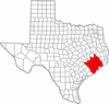 | |
|---|---|---|
| "Principal" cities | ||
| Other cities |
For a complete listing, see list of cities and towns in Houston–The Woodlands–Sugar Land MSA | |
| Unincorporated areas | ||
| Bodies of water | ||
