National Register of Historic Places listings in Brazos County, Texas

This is a list of the National Register of Historic Places listings in Brazos County, Texas.
This is intended to be a complete list of properties and districts listed on the National Register of Historic Places in Brazos County, Texas. There are two districts and 43 individual properties listed on the National Register in the county along with one formerly listed property. Five individually listed properties are Recorded Texas Historic Landmarks including one that is also a State Antiquities Landmark. One district contains several more Recorded Texas Historic Landmarks.
- This National Park Service list is complete through NPS recent listings posted October 11, 2018.[1]
Current listings
The locations of National Register properties and districts may be seen in a mapping service provided.[2]
| [3] | Name on the Register[4] | Image | Date listed[5] | Location | City or town | Description |
|---|---|---|---|---|---|---|
| 1 | Allen Academy Memorial Hall | September 25, 1987 (#87001603) |
1100 blk. of Ursuline 30°40′35″N 96°21′43″W / 30.676389°N 96.361944°W |
Bryan | Historic Resources of Bryan MRA | |
| 2 | Allen Block | .jpg) |
September 25, 1987 (#87001604) |
400-422 N. Main St. 30°40′37″N 96°22′23″W / 30.67686°N 96.37307°W |
Bryan | Historic Resources of Bryan MRA |
| 3 | R. O. Allen House-Allen Academy | September 25, 1987 (#87001605) |
1120 Ursuline 30°40′35″N 96°21′37″W / 30.676389°N 96.360278°W |
Bryan | Historic Resources of Bryan MRA | |
| 4 | Armstrong House-Allen Academy | September 25, 1987 (#87001606) |
1200 Ursuline 30°40′34″N 96°21′35″W / 30.676111°N 96.359722°W |
Bryan | Historic Resources of Bryan MRA | |
| 5 | R. Q. Astin House | 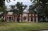 |
September 25, 1987 (#87001607) |
508 W. 26th St. 30°40′29″N 96°22′41″W / 30.67465°N 96.37793°W |
Bryan | Historic Resources of Bryan MRA |
| 6 | E. J. Blazek House | 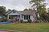 |
September 25, 1987 (#87001608) |
409 W. 30th St. 30°40′13″N 96°22′39″W / 30.67014°N 96.37763°W |
Bryan | Historic Resources of Bryan MRA |
| 7 | Bryan Carnegie Library | 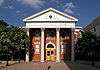 |
October 27, 1976 (#76002009) |
111 S. Main St. 30°40′23″N 96°22′24″W / 30.67301°N 96.37324°W |
Bryan | State Antiquities Landmark, Recorded Texas Historic Landmark |
| 8 | Bryan Compress and Warehouse | .jpg) |
September 25, 1987 (#87001609) |
911 N. Bryan Ave. 30°40′55″N 96°22′22″W / 30.68196°N 96.37270°W |
Bryan | Historic Resources of Bryan MRA |
| 9 | Bryan Ice House | 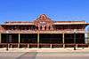 |
September 25, 1987 (#87001610) |
107 E. Martin Luther King 30°40′48″N 96°22′20″W / 30.67994°N 96.37224°W |
Bryan | Historic Resources of Bryan MRA |
| 10 | Bryan Municipal Building | 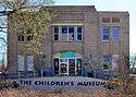 |
February 20, 2002 (#02000116) |
111 E. 27th St. 30°40′21″N 96°22′20″W / 30.67250°N 96.37234°W |
Bryan | Historic Resources of Bryan MRA |
| 11 | Cavitt House | 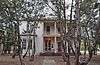 |
October 27, 1976 (#76002010) |
713 E. 30th St. 30°40′01″N 96°22′00″W / 30.66691°N 96.36659°W |
Bryan | Recorded Texas Historic Landmark, part of East Side Historic District |
| 12 | James O. Chance House | .jpg) |
September 25, 1987 (#87001612) |
102 S. Parker Ave. 30°40′25″N 96°22′31″W / 30.67372°N 96.37541°W |
Bryan | Historic Resources of Bryan MRA |
| 13 | CSPS Lodge-Griesser Bakery | .jpg) |
September 25, 1987 (#87001611) |
304 N. Logan Ave. 30°40′35″N 96°22′42″W / 30.67635°N 96.37825°W |
Bryan | Historic Resources of Bryan MRA |
| 14 | East Side Historic District | 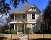 |
September 25, 1987 (#87001613) |
Roughly bounded by Houston, E. 29th, Haswell, and E. 30th Sts. 30°40′06″N 96°22′03″W / 30.668333°N 96.3675°W |
Bryan | Includes Recorded Texas Historic Landmarks; Historic Resources of Bryan MRA |
| 15 | Eugene Edge House | 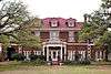 |
September 25, 1987 (#87001614) |
609 S. Ennis Ave. 30°39′54″N 96°21′57″W / 30.66495°N 96.36593°W |
Bryan | Recorded Texas Historic Landmark; Historic Resources of Bryan MRA |
| 16 | English-Dansby House | 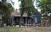 |
September 25, 1987 (#87001615) |
204 W. 28th St. 30°40′20″N 96°22′30″W / 30.67221°N 96.37496°W |
Bryan | Historic Resources of Bryan MRA |
| 17 | English-Poindexter House | 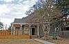 |
September 25, 1987 (#87001616) |
206 W. 28th St. 30°40′20″N 96°22′30″W / 30.67217°N 96.37513°W |
Bryan | Historic Resources of Bryan MRA |
| 18 | First National Bank and Trust Building | 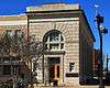 |
September 25, 1987 (#87001618) |
120 N. Main St. 30°40′28″N 96°22′24″W / 30.67456°N 96.37346°W |
Bryan | Historic Resources of Bryan MRA |
| 19 | First State Bank and Trust Building | 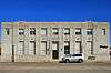 |
September 25, 1987 (#87001619) |
100 W. 25th St. 30°40′29″N 96°22′25″W / 30.67486°N 96.37358°W |
Bryan | Historic Resources of Bryan MRA |
| 20 | Walter J. Higgs House | September 25, 1987 (#87001620) |
609 N. Tabor Ave. 30°40′44″N 96°22′17″W / 30.67894°N 96.37139°W |
Bryan | Historic Resources of Bryan MRA | |
| 21 | House at 109 N. Sterling | .jpg) |
September 25, 1987 (#87001623) |
109 N. Sterling Ave. 30°40′30″N 96°22′37″W / 30.67489°N 96.37699°W |
Bryan | Historic Resources of Bryan MRA |
| 22 | House at 1401 Baker | September 25, 1987 (#87001621) |
1401 Baker Ave. 30°40′16″N 96°21′58″W / 30.67101°N 96.36610°W |
Bryan | Historic Resources of Bryan MRA | |
| 23 | House at 407 N. Parker | September 25, 1987 (#87001624) |
407 N. Parker Ave. 30°40′39″N 96°22′28″W / 30.67744°N 96.37448°W |
Bryan | Historic Resources of Bryan MRA | |
| 24 | House at 600 N. Washington | September 25, 1987 (#87001626) |
600 N. Washington Ave. 30°40′42″N 96°22′15″W / 30.67838°N 96.37087°W |
Bryan | Historic Resources of Bryan MRA | |
| 25 | House at 603 E. Thirty-first | September 25, 1987 (#87001627) |
603 E. 31st St. 30°39′58″N 96°22′08″W / 30.66622°N 96.36876°W |
Bryan | Historic Resources of Bryan MRA | |
| 26 | House at 604 E. Twenty-seventh | September 25, 1987 (#87001629) |
604 E. 27th 30°40′20″N 96°22′03″W / 30.67231°N 96.36759°W |
Bryan | Historic Resources of Bryan MRA | |
| 27 | Humpty Dumpty Store | .jpg) |
September 25, 1987 (#87001631) |
218 N. Bryan Ave. 30°40′32″N 96°22′26″W / 30.67556°N 96.37397°W |
Bryan | Historic Resources of Bryan MRA |
| 28 | Edward J. Jenkins House |  |
September 25, 1987 (#87001633) |
607 E. 27th St. 30°40′19″N 96°22′03″W / 30.67193°N 96.36749°W |
Bryan | Recorded Texas Historic Landmark; Historic Resources of Bryan MRA |
| 29 | J. M. Jones House | September 25, 1987 (#87001634) |
812 S. Ennis Ave. 30°39′47″N 96°22′07″W / 30.66314°N 96.36862°W |
Bryan | Historic Resources of Bryan MRA | |
| 30 | E. A. Kemp House | .jpg) |
September 25, 1987 (#87001636) |
606 W. 17th St. 30°40′58″N 96°22′41″W / 30.68265°N 96.37796°W |
Bryan | Historic Resources of Bryan MRA |
| 31 | La Salle Hotel | 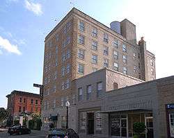 |
May 26, 2000 (#00000555) |
120 S. Main St. 30°40′23″N 96°22′25″W / 30.673056°N 96.373611°W |
Bryan | Recorded Texas Historic Landmark |
| 32 | McDougal-Jones House |  |
September 25, 1987 (#87001637) |
600 E. 27th St. 30°40′20″N 96°22′04″W / 30.67232°N 96.36783°W |
Bryan | Historic Resources of Bryan MRA |
| 33 | Moore House | September 25, 1987 (#87001638) |
500 E. 25th St. 30°40′28″N 96°22′07″W / 30.67441°N 96.36862°W |
Bryan | Historic Resources of Bryan MRA | |
| 34 | Noto House | September 25, 1987 (#87001639) |
900 N. Parker Ave. 30°40′53″N 96°22′28″W / 30.68143°N 96.37437°W |
Bryan | Historic Resources of Bryan MRA | |
| 35 | Dr. William Holt Oliver House |  |
September 25, 1987 (#87001640) |
602 W. 26th St. 30°40′28″N 96°22′43″W / 30.67456°N 96.37862°W |
Bryan | Historic Resources of Bryan MRA |
| 36 | Parker Lumber Company Complex | 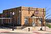 |
September 25, 1987 (#87001641) |
419 N. Main St. 30°40′38″N 96°22′21″W / 30.67723°N 96.37248°W |
Bryan | Historic Resources of Bryan MRA |
| 37 | Milton Parker House | 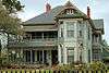 |
September 25, 1987 (#87001642) |
200 S. Congress St. 30°40′24″N 96°22′52″W / 30.67325°N 96.38102°W |
Bryan | Historic Resources of Bryan MRA |
| 38 | Saint Andrew's Episcopal Church | 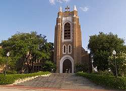 |
September 25, 1987 (#87001646) |
217 W. 26th St. 30°40′25″N 96°22′30″W / 30.67374°N 96.37497°W |
Bryan | Historic Resources of Bryan MRA |
| 39 | Saint Anthony's Catholic Church | 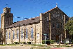 |
September 25, 1987 (#87001647) |
306 S. Parker Ave. 30°40′16″N 96°22′32″W / 30.671111°N 96.375556°W |
Bryan | Historic Resources of Bryan MRA |
| 40 | Sausley House | .jpg) |
September 25, 1987 (#87001643) |
700 N. Washington Ave. 30°40′45″N 96°22′14″W / 30.67919°N 96.37067°W |
Bryan | Historic Resources of Bryan MRA |
| 41 | Old Sinclair Station | .jpg) |
September 25, 1987 (#87001644) |
507 S. Texas Ave. 30°40′08″N 96°22′14″W / 30.66883°N 96.37050°W |
Bryan | Historic Resources of Bryan MRA |
| 42 | Smith-Barron House | June 20, 1988 (#87001645) |
100 S. Congress St. 30°40′27″N 96°22′51″W / 30.67424°N 96.38077°W |
Bryan | Historic Resources of Bryan MRA | |
| 43 | Roy C. Stone House | 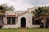 |
September 25, 1987 (#87001649) |
715 E. 31st St. 30°39′53″N 96°22′01″W / 30.66464°N 96.36685°W |
Bryan | Historic Resources of Bryan MRA |
| 44 | Temple Freda | 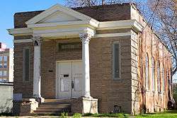 |
September 22, 1983 (#83003128) |
205 S. Parker Ave. 30°40′21″N 96°22′30″W / 30.6725°N 96.375°W |
Bryan | |
| 45 | Minnie Zulch Zimmerman House | .jpg) |
September 25, 1987 (#87001650) |
308 N. Washington Ave. 30°40′34″N 96°22′16″W / 30.67611°N 96.37105°W |
Bryan | Historic Resources of Bryan MRA |
Former listings
| [3] | Name on the Register | Image | Date listed | Date removed | Location | City or town | Summary |
|---|---|---|---|---|---|---|---|
| 1 | First Baptist Church | September 25, 1987 (#87001617) | August 30, 1994 | 201 S Washington Ave. |
Bryan |
See also
References
- ↑ "National Register of Historic Places: Weekly List Actions". National Park Service, United States Department of the Interior. Retrieved on October 11, 2018.
- ↑ The latitude and longitude information provided in this table was derived originally from the National Register Information System, which has been found to be fairly accurate for about 99% of listings. For about 1% of NRIS original coordinates, experience has shown that one or both coordinates are typos or otherwise extremely far off; some corrections may have been made. A more subtle problem causes many locations to be off by up to 150 yards, depending on location in the country: most NRIS coordinates were derived from tracing out latitude and longitudes from USGS topographical quadrant maps created under the North American Datum of 1927, which differs from the current, highly accurate WGS84 GPS system used by most on-line maps. Chicago is about right, but NRIS longitudes in Washington are higher by about 4.5 seconds, and are lower by about 2.0 seconds in Maine. Latitudes differ by about 1.0 second in Florida. Some locations in this table may have been corrected to current GPS standards.
- 1 2 Numbers represent an ordering by significant words. Various colorings, defined here, differentiate National Historic Landmarks and historic districts from other NRHP buildings, structures, sites or objects.
- ↑ National Park Service (2010-07-09). "National Register Information System". National Register of Historic Places. National Park Service.
- ↑ The eight-digit number below each date is the number assigned to each location in the National Register Information System database, which can be viewed by clicking the number.
External links
![]()
Places adjacent to National Register of Historic Places listings in Brazos County, Texas | ||||||||||
|---|---|---|---|---|---|---|---|---|---|---|
| ||||||||||


Municipalities and communities of Brazos County, Texas, United States | ||
|---|---|---|
| Cities | 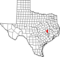 | |
| Towns | ||
| CDP | ||
| Unincorporated communities | ||
| Ghost towns | ||