Brazos Country, Texas
| Brazos Country, Texas | |
|---|---|
| City | |
 Brazos Country | |
| Coordinates: 29°45′11″N 96°2′17″W / 29.75306°N 96.03806°W | |
| Country | United States |
| State | Texas |
| County | Austin |
| Incorporated | 2000 |
| Area | |
| • Total | 5 sq mi (14 km2) |
| • Land | 5 sq mi (14 km2) |
| • Water | 0.10 sq mi (.26 km2) |
| Population (2010) | |
| • Total | 469 |
| • Density | 87/sq mi (34/km2) |
| ZIP code | 77474 |
| FIPS code | 48-10090 |
| GNIS feature ID | 1923026 |
| Website |
www |
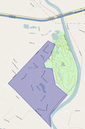
Brazos Country is a residential community in Austin County, Texas.
Geography
Brazos Country is located south of Interstate 10 and 7 miles (11 km) southeast of Sealy. Downtown Houston is 43 miles (69 km) to the east. The eastern city limits of Brazos Country run along the west bank of the Brazos River. The only entrances to the city are from Chew Road. As of the 2010 census the population was 469.[1]
There are several small, unnamed bodies of water within Brazos Country, likely manmade.[2]
Brazos Country is located at 29°45′11″N 96°2′17″W / 29.75306°N 96.03806°W. According to the United States Census Bureau, the city has a total area of 5.5 square miles (14 km2), of which, 5.4 square miles (14 km2) of it is land and 0.1 square miles (0.26 km2) is water.[3]
| Historical population | |||
|---|---|---|---|
| Census | Pop. | %± | |
| 2010 | 469 | — | |
| Est. 2016 | 486 | [4] | 3.6% |
| U.S. Decennial Census[5] | |||
Government
City government is by mayor and city council. The Sealy Independent School District serves area students.
Brazos Country encompasses the River Ridge Golf Club [6] which occupies the west bank of the Brazos River.
History
Development of the area began in the late 1970s, and the city was incorporated in May 2000.[7][8]
References
- ↑ "Geographic Identifiers: 2010 Demographic Profile Data (G001): Brazos Country city, Texas". U.S. Census Bureau, American Factfinder. Retrieved August 26, 2013.
- ↑ "Google Maps". Google Maps. Retrieved 2017-06-17.
- ↑ "US Gazetteer Files 2016-Places-Texas". US Census. Retrieved 11 January 2017.
- ↑ "Population and Housing Unit Estimates". Retrieved June 9, 2017.
- ↑ "Census of Population and Housing". Census.gov. Archived from the original on May 12, 2015. Retrieved June 4, 2015.
- ↑
- ↑ "Boundary Changes". Geographic Change Notes: Texas. Population Division, United States Census Bureau. 2006-05-19. Archived from the original on 2010-08-06. Retrieved 2008-05-27.
- ↑ Brazos Country, Texas - Handbook of Texas.
External links
Municipalities and communities of Austin County, Texas, United States | ||
|---|---|---|
| Cities | 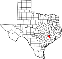 | |
| Town | ||
| Unincorporated communities | ||
| Ghost towns |
| |
| Footnotes | ‡This populated place also has portions in an adjacent county or counties | |
Coordinates: 29°45′14″N 96°03′02″W / 29.75389°N 96.05056°W