Bluefield, West Virginia
| Bluefield, West Virginia | ||
|---|---|---|
| City | ||
| City of Bluefield | ||
 | ||
| ||
| Nickname(s): Nature's Air Conditioned City | ||
 Location of Bluefield in Mercer County, West Virginia. | ||
 Location in the state of West Virginia | ||
| Coordinates: 37°15′44″N 81°13′7″W / 37.26222°N 81.21861°WCoordinates: 37°15′44″N 81°13′7″W / 37.26222°N 81.21861°W | ||
| Country | United States | |
| State | West Virginia | |
| County | Mercer | |
| Government | ||
| • Mayor | Ron Martin | |
| Area[1] | ||
| • City | 8.86 sq mi (22.95 km2) | |
| • Land | 8.86 sq mi (22.95 km2) | |
| • Water | 0 sq mi (0 km2) | |
| Elevation | 2,611 ft (795.8 m) | |
| Population (2010)[2] | ||
| • City | 10,447 | |
| • Estimate (2016)[3] | 10,191 | |
| • Density | 1,179.1/sq mi (455.3/km2) | |
| • Metro | 107,578 | |
| Time zone | UTC-5 (EST) | |
| • Summer (DST) | UTC-4 (EDT) | |
| ZIP code | 24701 | |
| Area code(s) | 304, 681 | |
| FIPS code | 54-08524 | |
| GNIS feature ID | 1553939[4] | |
| Website | Official website | |
Bluefield is a city in Mercer County, West Virginia, United States. The population was 10,447 at the 2010 census. It is the core city of the Bluefield WV-VA micropolitan area, which has a population of 107,342.
Geography
Bluefield is located at 37°15′44″N 81°13′7″W / 37.26222°N 81.21861°W (37.262219, -81.218674)[5] in the Appalachian Mountains of West Virginia across the state border from Bluefield, Virginia.
According to the United States Census Bureau, the city has a total area of 8.86 square miles (22.95 km2), all land.[1]
Demographics
| Historical population | |||
|---|---|---|---|
| Census | Pop. | %± | |
| 1890 | 1,775 | — | |
| 1900 | 4,644 | 161.6% | |
| 1910 | 11,188 | 140.9% | |
| 1920 | 15,282 | 36.6% | |
| 1930 | 19,339 | 26.5% | |
| 1940 | 20,641 | 6.7% | |
| 1950 | 21,506 | 4.2% | |
| 1960 | 19,256 | −10.5% | |
| 1970 | 15,921 | −17.3% | |
| 1980 | 16,060 | 0.9% | |
| 1990 | 12,756 | −20.6% | |
| 2000 | 11,451 | −10.2% | |
| 2010 | 10,447 | −8.8% | |
| Est. 2016 | 10,191 | [3] | −2.5% |
| U.S. Decennial Census[6] 2014 Estimate[7] | |||
2010 census
As of the census[2] of 2010, there were 10,447 people, 4,643 households, and 2,772 families residing in the city. The population density was 1,179.1 inhabitants per square mile (455.3/km2). There were 5,457 housing units at an average density of 615.9 per square mile (237.8/km2). The racial makeup of the city was 73.7% White, 23.0% African American, 0.3% Native American, 0.5% Asian, 0.2% from other races, and 2.3% from two or more races. Hispanic or Latino of any race were 0.9% of the population.
There were 4,643 households of which 26.1% had children under the age of 18 living with them, 38.6% were married couples living together, 16.5% had a female householder with no husband present, 4.6% had a male householder with no wife present, and 40.3% were non-families. 35.0% of all households were made up of individuals and 15.1% had someone living alone who was 65 years of age or older. The average household size was 2.21 and the average family size was 2.83.
The median age in the city was 43.1 years. 20.8% of residents were under the age of 18; 9.2% were between the ages of 18 and 24; 22.2% were from 25 to 44; 28.6% were from 45 to 64; and 19.2% were 65 years of age or older. The gender makeup of the city was 46.8% male and 53.2% female.
2000 census
As of the census[8] of 2000, there were 11,451 people, 5,038 households, and 3,078 families residing in the city. The population density was 1,311.3 people per square mile (506.4/km²). There were 5,966 housing units at an average density of 683.2 per square mile (263.9/km²). The racial makeup of the city was 75.84% White, 22.14% African American, 0.12% Native American, 0.56% Asian, 0.01% Pacific Islander, 0.21% from other races, and 1.13% from two or more races. Hispanic or Latino of any race were 0.52% of the population.
There were 5,038 households out of which 24.7% had children under the age of 18 living with them, 43.5% were married couples living together, 13.9% had a female householder with no husband present, and 38.9% were non-families. 34.9% of all households were made up of individuals and 17.5% had someone living alone who was 65 years of age or older. The average household size was 2.23 and the average family size was 2.87.
The age distribution was 21.5% under the age of 18, 9.0% from 18 to 24, 23.5% from 25 to 44, 24.5% from 45 to 64, and 21.5% who were 65 years of age or older. The median age was 42 years. For every 100 females, there were 84.4 males. For every 100 females age 18 and over, there were 79.5 males.
The median income for a household in the city was $27,672, and the median income for a family was $36,508. Males had a median income of $31,396 versus $21,051 for females. The per capita income for the city was $17,751. About 13.0% of families and 19.3% of the population were below the poverty line, including 28.2% of those under age 18 and 10.9% of those age 65 or over.
History
The European-American history of Bluefield began in the 18th century, when two families settled in a rugged and remote part of what is now southern West Virginia. Others joined them and they built a small village with a mill, a church, a one-room schoolhouse, and a fort for defending the settlement against invasions by the Shawnee Indian tribe, which had a village on the banks of the Bluestone River.
In 1882, the descendants of the Davidson and Bailey family sold a portion of their land, when Captain John Fields of the Norfolk and Western Railway pioneered the area and began building a new railroad through the hills of Bluefield. The city is traditionally thought to be named after the chicory flowers in the area, which give the fields a purplish blue hue during the summer. Research has shown that this settlement, also known as Higginbotham's Summit in the 1880s, was probably named for the coal fields that were developed in the area of the Bluestone River.
Coal rush
Beneath the land of the Davidsons and Baileys lay the largest and richest deposit of bituminous coal in the world. The first seam was discovered in nearby Pocahontas, Virginia in the backyard of Jordan Nelson. President Frederick Kimball of the Norfolk and Western Railway described this as the "most spectacular find on the continent and indeed perhaps of the entire planet." The coal seam had been mentioned much earlier in Thomas Jefferson's Notes on the State of Virginia, but it was not mined until 1890.
Around that time, coal mines were developed in the area around Harman, Bluefield, War, and Pocahontas, which together were known as the Pocahontas Coal Fields. They helped support the Industrial Revolution in the United States. The development of the coal industry in this area created a boom in the local and national economy, and attracted immigrant European workers and migrant African Americans from the Deep South to the mountains in search of industrial work. During the Great War and World War II, coal from this area supplied the navies of the United States and United Kingdom.
In the late 19th century, the Norfolk and Western Company selected Bluefield as the site for its headquarters and repair center, which greatly stimulated the town's growth. In the one-year period from 1887 to 1888, passenger travel along the railroad increased 317%. As with the extremely accelerated growth of San Francisco during the gold rush, Bluefield became a city that seemed to spring up "overnight." Growth far outpaced the existing infrastructure. Urban sprawl and blight were common complaints in the early days, as workers crowded into aging housing.
The growth and decay of the city depended almost entirely upon Norfolk and Western Railroad. When coal tonnage was good and the market for coal was booming, Bluefield was essentially a "Little New York," as it was called in the day. A bustling metropolis, it had a nightlife and a personality that was "a little bit Chicago, a little bit New York, and a whole lot of Pittsburgh"—rugged and with steel and coal embedded in its soul.
The coal boom generated a flood of money in the area. Nearby Bramwell, incorporated in 1888, boasted that it was the "Millionaires' Town" because more millionaires per capita lived there than anywhere in the nation. The city also had more automobiles per capita than any other city in the country.
In 1889, the city of Bluefield was officially incorporated. The city government was always known in those days as being corrupt, inefficient, with drunken brawls and fights breaking out on the floor of City Hall on an almost daily basis.
With a strong ethnic community, Bluefield was the site of the 1895 founding of the Bluefield Colored Institute, an historically black college. It developed as today's Bluefield State College.
20th century
During the 1920s, the twelve-story West Virginian Hotel was built. It has been adapted and in the 21st century is operated as the West Virginia Manor and Retirement Home. In 1924, nearby Graham, Virginia decided to rename itself as Bluefield to try to unite the two towns, which had been feuding since the civil war. Nobel Prize–winning economist and mathematician John Forbes Nash was born in Bluefield in 1928.
The Great Depression was particularly damaging to Bluefield. With the government nearly bankrupt, after a series of devastating structural fires swept through the downtown area, the city was nearly destroyed. It was not until the outbreak of World War II that coal production revived.
The strategic importance of the city was so great that Adolf Hitler put Bluefield on his reputed list of German air raid targets in the United States. Air raid practice drills were common in the city during this time.
Thomas Edd Mayfield, one of the Mayfield Brothers Bluegrass musicians of West Texas, died of leukemia in a Bluefield hospital in 1958 at the age of thirty-two. He was on tour here with Bill Monroe and the Bluegrass Boys.
The Interstate Highway System was constructed through East River Mountain on December 20, 1974; for the first time automobile traffic could reach the city without crossing the top of the mountain. The dependence on the railroads waned and restructuring changed the industry. Bluefield lost jobs and population as a result. Its Amtrak station closed in the 1980s. Mercer Mall, the area's major shopping mall, opened in 1980.
Educational institutions
- Bluefield High School
- Bluefield State College
- Valley View Seventh-day Adventist School
Climate
Bluefield is a mountain city with a humid subtropical climate (Cfa) bordering on humid continental (Dfa/Dfb) or highland climate, due to its elevation. It is characterized by moderately cold, snowy winters and pleasantly warm to hot summers. The hottest temperature ever recorded in the city was 97 °F (36 °C) with the coldest temperature at −21 °F.
| Climate data for Bluefield, West Virginia | |||||||||||||
|---|---|---|---|---|---|---|---|---|---|---|---|---|---|
| Month | Jan | Feb | Mar | Apr | May | Jun | Jul | Aug | Sep | Oct | Nov | Dec | Year |
| Record high °F (°C) | 72 (22) |
75 (24) |
83 (28) |
88 (31) |
89 (32) |
97 (36) |
96 (36) |
95 (35) |
93 (34) |
88 (31) |
81 (27) |
74 (23) |
97 (36) |
| Average high °F (°C) | 42 (6) |
46 (8) |
54 (12) |
65 (18) |
72 (22) |
79 (26) |
81 (27) |
81 (27) |
75 (24) |
66 (19) |
56 (13) |
45 (7) |
64 (17) |
| Average low °F (°C) | 26 (−3) |
29 (−2) |
36 (2) |
45 (7) |
53 (12) |
61 (16) |
65 (18) |
64 (18) |
57 (14) |
47 (8) |
39 (4) |
30 (−1) |
46 (8) |
| Record low °F (°C) | −21 (−29) |
−9 (−23) |
−2 (−19) |
15 (−9) |
24 (−4) |
37 (3) |
40 (4) |
39 (4) |
30 (−1) |
18 (−8) |
7 (−14) |
−13 (−25) |
−21 (−29) |
| Average precipitation inches (mm) | 2.90 (73.7) |
2.86 (72.6) |
3.51 (89.2) |
3.34 (84.8) |
4.31 (109.5) |
4.14 (105.2) |
4.17 (105.9) |
3.26 (82.8) |
3.14 (79.8) |
2.50 (63.5) |
2.69 (68.3) |
2.91 (73.9) |
39.73 (1,009.2) |
| Average snowfall inches (cm) | 9.4 (23.9) |
8.2 (20.8) |
4.2 (10.7) |
1.4 (3.6) |
0 (0) |
0 (0) |
0 (0) |
0 (0) |
0 (0) |
0.1 (0.3) |
1.4 (3.6) |
6.7 (17) |
31.4 (79.8) |
| Source: The Weather Channel[9] | |||||||||||||
Culture
Bluefield prides itself on its hospitable climate. Since 1938 the Chamber of Commerce has given free lemonade when the temperature has surpassed 90 °F.[10] The city's motto is "nature's air conditioned city, where the summer spends the winter."
Jazz musician Louis Jordan's song "Salt Pork, W.Va." was inspired by his time in a Bluefield jail.
The song "Sweet Georgia Brown" was co-written by Maceo Pinkard, a native of Bluefield.
A controversy exists over whether or not Hank Williams was last seen alive in Bluefield on his way to a show in Ohio. He was discovered dead in Oak Hill, West Virginia.
Bluefield is mentioned in the Stylistics' 1973 song Rockin' Roll Baby as the birthplace of Li'l Joe.
Bluefield was the hometown of fictional character Rita Stapleton Bauer on the CBS soap Guiding Light.
Sports
Bluefield was the home of the Appalachian League (rookie) Bluefield Orioles baseball team until 2010. The Orioles have had a team in Bluefield since 1958, which was the longest relationship between a parent club and a town in affiliated baseball.[11][12] The Toronto Blue Jays replaced Baltimore for the 2011 season with the Bluefield Blue Jays. The team plays at Bowen Field (former Orioles stadium) and several renovations have been made to the ball park.
Bluefield High School has 522 state championships in all sports, which is more than any other AA school in the state. Also Bluefield ranks third in total football state championships with ten. They trail now closed Ceredo-Kenova High School (12) and national powerhouse Parkersburg High School (11).
Bluefield is largely a football town and the rivalry between the Bluefield Beavers and their sister city Bluefield, Virginia's Graham G-Men always draws a large crowd at Mitchell Stadium. 2005 saw the introduction of the Bluefield Barons, an Alliance Football League team.
Bluefield is also home to the East River Soccer Complex which has five fields and hosts local high school and college soccer games. The Southern West Virginia King's Warriors of the USL PDL play their home games at the East River Soccer Complex.[13]
Bluefield is also the home of the Rough and Rowdy Brawl, an amateur boxing tournament owned by barstool sports and broadcast on pay per view via its website. The tournament features many local and non-local fighters who compete in 3 one minute rounds.
Notable people
- The famous mathematician John Forbes Nash, Jr. was born in Bluefield on June 13, 1928. His life became the basis for Sylvia Nasar's biography, A Beautiful Mind, as well as a film of the same name starring Russell Crowe.
- Newspaper publisher John S. Knight was born in Bluefield.
- The horror punk band, Blitzkid began in Bluefield, WV in the winter of 1997.
- Intellectual, professor, and solidarity activist Steven Salaita is from Bluefield, WV.
References
- 1 2 "US Gazetteer files 2010". United States Census Bureau. Archived from the original on January 24, 2012. Retrieved 2013-01-24.
- 1 2 "American FactFinder". United States Census Bureau. Retrieved 2013-01-24.
- 1 2 "Population and Housing Unit Estimates". Retrieved June 9, 2017.
- ↑ "US Board on Geographic Names". United States Geological Survey. 2007-10-25. Retrieved 2008-01-31.
- ↑ "US Gazetteer files: 2010, 2000, and 1990". United States Census Bureau. 2011-02-12. Retrieved 2011-04-23.
- ↑ United States Census Bureau. "Census of Population and Housing". Archived from the original on May 12, 2015. Retrieved August 27, 2013.
- ↑ "Population Estimates". United States Census Bureau. Archived from the original on May 22, 2015. Retrieved June 20, 2015.
- ↑ "American FactFinder". United States Census Bureau. Archived from the original on September 11, 2013. Retrieved 2008-01-31.
- ↑ "Monthly Averages for Bluefield, WV". The Weather Channel. Retrieved 2011-05-17.
- ↑ http://cityofbluefield.com//index.php?option=com_content&task=view&id=178&Itemid=272
- ↑ "Orioles leaving Bluefield". Bluefield Daily Telegraph. August 28, 2010. Retrieved August 29, 2010.
- ↑ "Orioles out of Bluefield". Orioles Insider: Baltimore Sun. Retrieved August 29, 2010.
- ↑ "King's Warriors Make Move To Bluefield". United Soccer Leagues (USL). February 8, 2014. Archived from the original on February 23, 2014. Retrieved February 8, 2014.
External links
| Wikimedia Commons has media related to Bluefield, West Virginia. |

- City website
Municipalities and communities of Mercer County, West Virginia, United States | ||
|---|---|---|
| Cities | 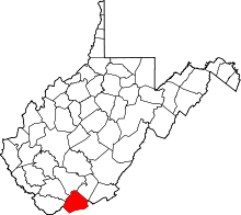 | |
| Towns | ||
| CDPs | ||
| Other communities |
| |
| Ghost town | ||
| Footnotes | ‡This populated place also has portions in an adjacent county or counties | |
