Crystal, West Virginia
| Crystal, West Virginia | |
|---|---|
| Unincorporated community | |
 Crystal, West Virginia Location within the state of West Virginia  Crystal, West Virginia Crystal, West Virginia (the US) | |
| Coordinates: 37°22′24″N 81°16′17″W / 37.37333°N 81.27139°WCoordinates: 37°22′24″N 81°16′17″W / 37.37333°N 81.27139°W | |
| Country | United States |
| State | West Virginia |
| County | Mercer |
| Elevation | 2,244 ft (684 m) |
| Time zone | UTC-5 (Eastern (EST)) |
| • Summer (DST) | UTC-4 (EDT) |
| Area code(s) | 304 & 681 |
| GNIS feature ID | 2707599[1] |
Crystal is an unincorporated community in Mercer County, West Virginia, United States. Crystal is located on Crane Creek and County Route 11 7.6 miles (12.2 km) north-northwest of Bluefield.[2]
The community most likely derives its name from the Crystal Coal and Coke Company.[3]
References
- ↑ "Crystal". Geographic Names Information System. United States Geological Survey.
- ↑ Mercer County, West Virginia General Highway Map (PDF) (Map). West Virginia Department of Transportation. 2011. p. 2. Archived from the original (PDF) on 2012-03-19. Retrieved November 6, 2011.
- ↑ Kenny, Hamill (1945). West Virginia Place Names: Their Origin and Meaning, Including the Nomenclature of the Streams and Mountains. Piedmont, WV: The Place Name Press. p. 193.
Municipalities and communities of Mercer County, West Virginia, United States | ||
|---|---|---|
| Cities | 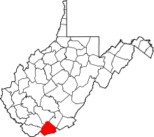 | |
| Towns | ||
| CDPs | ||
| Other communities |
| |
| Ghost town | ||
| Footnotes | ‡This populated place also has portions in an adjacent county or counties | |
This article is issued from
Wikipedia.
The text is licensed under Creative Commons - Attribution - Sharealike.
Additional terms may apply for the media files.