Wolfe, West Virginia
| Wolfe, West Virginia | |
|---|---|
| Unincorporated community | |
 Wolfe, West Virginia Location within the state of West Virginia  Wolfe, West Virginia Wolfe, West Virginia (the US) | |
| Coordinates: 37°18′26″N 81°19′43″W / 37.30722°N 81.32861°WCoordinates: 37°18′26″N 81°19′43″W / 37.30722°N 81.32861°W | |
| Country | United States |
| State | West Virginia |
| County | Mercer |
| Elevation | 2,303 ft (702 m) |
| Time zone | UTC-5 (Eastern (EST)) |
| • Summer (DST) | UTC-4 (EDT) |
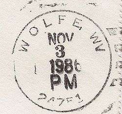
| ZIP code | 24751[1] |
| Area code(s) | 304 & 681 |
| GNIS feature ID | 1556018[2] |
Wolfe is an unincorporated community in Mercer County, West Virginia, United States. Wolfe is located along West Virginia Route 102 at the Virginia border and is 0.5 miles (0.80 km) east-northeast of Pocahontas, Virginia. Wolfe had a post office, which closed on June 25, 2011.[3]
See also
![]()
References
- ↑ United States Postal Service (2012). "USPS - Look Up a ZIP Code". Retrieved 2012-02-15.
- ↑ U.S. Geological Survey Geographic Names Information System: Wolfe, West Virginia
- ↑ "Postmaster Finder - Post Offices by ZIP Code". United States Postal Service. Retrieved September 26, 2011.
External links
![]()
Municipalities and communities of Mercer County, West Virginia, United States | ||
|---|---|---|
| Cities | 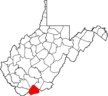 | |
| Towns | ||
| CDPs | ||
| Other communities |
| |
| Ghost town | ||
| Footnotes | ‡This populated place also has portions in an adjacent county or counties | |
This article is issued from
Wikipedia.
The text is licensed under Creative Commons - Attribution - Sharealike.
Additional terms may apply for the media files.