Suryabinayak Municipality
| Suryabinayak Municipality सुर्यविनायक नगरपालिका | |
|---|---|
| Urban Municipality | |
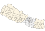
 Suryabinayak Municipality Location in Nepal | |
| Coordinates: 27°40′N 85°24′E / 27.667°N 85.400°ECoordinates: 27°40′N 85°24′E / 27.667°N 85.400°E | |
| Country | Nepal |
| Province | Province No. 3 |
| District | Bhaktapur District |
| Established | Dec 2014 |
| Expanded | March 2017 |
| Government | |
| • Mayor | Basu Thapa (NCP) |
| • Deputy Mayor | Juna Basnet (NCP) |
| Area | |
| • Total | 42.45 km2 (16.39 sq mi) |
| Population (2011 Nepal census) | |
| • Total | 78,490 |
| • Density | 1,848.99/km2 (4,788.9/sq mi) |
| Website |
suryabinayakmun |
Suryabinayak Municipality (Nepali: सुर्यविनायक नगरपालिका) is a municipality in Nepal that was created in December 2014 through the merger of the Village development committees of Kautunje (the municipality's centre[1]), Sipadol, Nankhel and Chitpol.[2] The municipality's name stems from the local Suryavinayak Temple.[1] In March 2017, under new local level restructuring,[3] Suryabinayak Municipality was expanded to include the neighboring municipality of Anantalingeshwor, adding four more previous VDCs of Sirutar, Gundu, Dadhikot and Balkot. According to the 2011 Nepal census, the predecessors of Suryabinayak Municipality had a population of 78,490.[4]
Transportation
Busses of Sajha Yatayat serve Suryabinayak and link it to Kathmandu.[5]
References
- 1 2 "सुर्यविनायक नगरपालिका परिचय" (in Nepali). सुर्यविनायक नगरपालिका. Retrieved 1 May 2018.
- ↑ "Govt announces 61 municipalities". The Kathmandu Post. 2 December 2014. Retrieved 1 May 2018.
- ↑ "New local level units come into existence". The Kathmandu Post. Retrieved 27 September 2017.
- ↑ "Nepal Census 2001". Nepal's Village Development Committees. Digital Himalaya. Archived from the original on 2008-10-12. Retrieved 2008-08-26.
- ↑ "Route". Sajha Yatayat. Retrieved 20 April 2018.
External links
Headquarter: Bhaktapur | |||
 |  | ||
This article is issued from
Wikipedia.
The text is licensed under Creative Commons - Attribution - Sharealike.
Additional terms may apply for the media files.