Changunarayan
| Changunarayan चाँगुनारायण | |
|---|---|
| Municipality | |
 Changunarayan | |
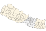
 Changunarayan Location in Nepal | |
| Coordinates: 27°43′00″N 85°25′47″E / 27.71667°N 85.42972°ECoordinates: 27°43′00″N 85°25′47″E / 27.71667°N 85.42972°E | |
| Country |
|
| Province | Province No. 3 |
| District | Bhaktapur |
| Government | |
| • Mayor | Som Prasad Mishra |
| Area | |
| • Total | 62.98 km2 (24.32 sq mi) |
| Population (2011) | |
| • Total | 55,430 |
| • Density | 880/km2 (2,300/sq mi) |
| • Religions | Hindu |
| Time zone | UTC+5:45 (NST) |
| Website |
changunarayanmun |
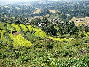
Changunarayan is a municipality in Kathmandu District in the Province No. 2 of Nepal and is part of the urban agglomeration of the Kathmandu Valley. The municipality was created through the merger of the former Village development committees Old-Changunarayan, Chhaling, Duwakot and Jhaukhel in 2014.[1] At the time of the 2011 Nepal census, the predecessors of Changunarayan Municipality had a population of 55,430.[2] In 2017, the municipality of Mahamanjushree Nagarkot was merged into Changunarayan.[3] The municipality is also home to the UNESCO World Heritage Site Changu Narayan.
See also
References
- ↑ "Govt announces 61 municipalities". The Kathmandu Post. 2 December 2014. Retrieved 1 May 2018.
- ↑ "Nepal Census 2001". Nepal's Village Development Committees. Digital Himalaya. Archived from the original on 2008-10-12. Retrieved 2008-08-26.
- ↑ "नगरकोट नगरपालिका" (in Nepali). नेपाल सरकार. Retrieved 1 May 2018.
Headquarter: Bhaktapur | |||
 |  | ||
This article is issued from
Wikipedia.
The text is licensed under Creative Commons - Attribution - Sharealike.
Additional terms may apply for the media files.