Saddlebrooke, Missouri
Saddlebrooke is a village located in extreme southern Christian County, Missouri, United States on U.S. Route 65. A small portion of the village extends into Taney County. It is a master-planned community which incorporated in 2003.[5][6] The population was 202 at the 2010 census.
Saddlebrooke, Missouri | |
|---|---|
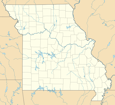 Saddlebrooke, Missouri Location of Saddlebrooke, Missouri | |
| Coordinates: 36°49′41″N 93°13′05″W | |
| Country | United States |
| State | Missouri |
| County | Christian, Taney |
| Area | |
| • Total | 7.01 sq mi (18.16 km2) |
| • Land | 7.01 sq mi (18.16 km2) |
| • Water | 0 sq mi (0 km2) |
| Elevation | 955 ft (291 m) |
| Population | |
| • Total | 202 |
| • Estimate (2018)[3] | 241 |
| • Density | 29/sq mi (11/km2) |
| Time zone | UTC-6 (Central (CST)) |
| • Summer (DST) | UTC-5 (CDT) |
| ZIP code | 65630 |
| Area code(s) | 417 |
| FIPS code | 29-63857[2] |
| GNIS feature ID | 2339759[4] |
| Website | saddlebrookepoa.com |
The Christian County portion of the village is part of the Springfield, Missouri Metropolitan Statistical Area, while the Taney County portion is part of the Branson, Missouri Micropolitan Statistical Area.
Geography
Saddlebrooke is located at 36°49′41″N 93°13′05″W (36.828056, -93.218056).[1]
According to the United States Census Bureau, the village has a total area of 7.01 square miles (18.16 km2), all land.[1]
Demographics
| Historical population | |||
|---|---|---|---|
| Census | Pop. | %± | |
| 2010 | 202 | — | |
| Est. 2018 | 241 | [7] | 19.3% |
| U.S. Decennial Census[8] | |||
At the 2010 census,[2] there were 202 people, 77 households and 68 families residing in the village. The population density was 28.8 inhabitants per square mile (11.1/km2). There were 87 housing units at an average density of 12.4 per square mile (4.8/km2). The racial makeup was 91.1% White, 1.5% Native American, 0.5% Asian, 3.0% from other races, and 4.0% from two or more races. Hispanic or Latino of any race were 4.5% of the population.
There were 77 households of which 27.3% had children under the age of 18 living with them, 83.1% were married couples living together, 3.9% had a female householder with no husband present, 1.3% had a male householder with no wife present, and 11.7% were non-families. 6.5% of all households were made up of individuals. The average household size was 2.62 and the average family size was 2.75.
The median age was 51.4 years. 20.3% of residents were under the age of 18; 3.9% were between the ages of 18 and 24; 16% were from 25 to 44; 44.1% were from 45 to 64; and 15.8% were 65 years of age or older. The gender makeup was 51.0% male and 49.0% female.
References
- "US Gazetteer files: 2010, 2000, and 1990". United States Census Bureau. 2011-02-12. Retrieved 2017-07-09.
- "U.S. Census website". United States Census Bureau. Retrieved 2008-01-31.
- "U.S. Census website". United States Census Bureau. Retrieved 2019-05-26.
- "US Board on Geographic Names". United States Geological Survey. 2007-10-25. Retrieved 2017-07-09.
- County Information Archived 2008-03-25 at the Wayback Machine - Christian County, Missouri web site. Retrieved May 13, 2008.
- "Table 4. Annual Estimates of the Population for Incorporated Places in Missouri: April 1, 2000 to July 1, 2007" (CSV). United States Census Bureau, Population Division. 2007-07-10. Retrieved 2008-07-11.
- "Population and Housing Unit Estimates". Retrieved June 9, 2017.
- "Census of Population and Housing". Census.gov. Retrieved June 4, 2015.
External links
Municipalities and communities of Christian County, Missouri, United States | ||
|---|---|---|
| Cities | 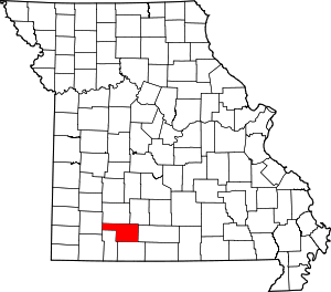 Map of Missouri highlighting Christian County | |
| Village | ||
| Townships |
| |
| CDP | ||
| Unincorporated communities | ||
| Ghost towns | ||
| Footnotes | ‡This populated place also has portions in an adjacent county or counties | |
Municipalities and communities of Taney County, Missouri, United States | ||
|---|---|---|
| Cities | 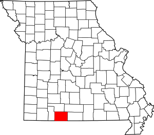 Map of Missouri highlighting Taney County | |
| Villages | ||
| Townships | ||
| CDP | ||
| Other unincorporated communities | ||
| Ghost towns | ||
| Footnotes | ‡This populated place also has portions in an adjacent county or counties | |
