Nærøysundet
| Nærøysundet | |
|---|---|
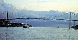 View of the Nærøysundet with the crossing Nærøysund Bridge | |
 Nærøysundet Location of the fjord  Nærøysundet Nærøysundet (Norway) | |
| Location | Trøndelag county, Norway |
| Coordinates | 64°50′31″N 11°12′00″E / 64.842°N 11.200°ECoordinates: 64°50′31″N 11°12′00″E / 64.842°N 11.200°E |
| Type | Strait |
| Primary inflows | Folda |
| Basin countries | Norway |
| Max. length | 20 kilometres (12 mi) |
Nærøysundet is a strait in the municipalities of Vikna and Nærøy in Trøndelag county, Norway. The village and administrative centre of Vikna, Rørvik, is located along the Nærøysundet, on the northwestern side. The 20-kilometre (12 mi) strait is crossed by the Nærøysund Bridge which connects the mainland and the island of Inner-Vikna. The shipping lane along the Norwegian coast passes through the strait, and the ship traffic is guided by the Nærøysund Lighthouse.[1][2][3]
References
- ↑ Godal, Anne Marit (ed.). "Nærøysundet". Store norske leksikon (in Norwegian). Oslo: Norsk nettleksikon. Retrieved 3 March 2015.
- ↑ Evensen, Knut Harald, ed. (2010). NAF Veibok 2010–2012 (in Norwegian) (29 ed.). Oslo: Norges Automobil-Forbund. pp. 86, 480.
- ↑ Lauritzen, Per Roger, ed. (2013). NAF Veibok 2014-2016 (in Norwegian) (30 ed.). Oslo: Norges Automobil-Forbund. pp. 110, 391&ndash, 392. ISBN 978-82-7167-124-2.
This article is issued from
Wikipedia.
The text is licensed under Creative Commons - Attribution - Sharealike.
Additional terms may apply for the media files.