Mellom-Vikna
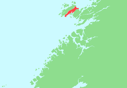 | |
 Mellom-Vikna Location of the island  Mellom-Vikna Mellom-Vikna (Norway) | |
| Geography | |
|---|---|
| Location | Trøndelag, Norway |
| Coordinates | 64°53′46″N 10°58′35″E / 64.8960°N 10.9763°ECoordinates: 64°53′46″N 10°58′35″E / 64.8960°N 10.9763°E |
| Area | 57.43 km2 (22.17 sq mi) |
| Length | 21.5 km (13.36 mi) |
| Width | 4.4 km (2.73 mi) |
| Highest elevation | 157 m (515 ft) |
| Highest point | Dragstinden |
| Administration | |
|
Norway | |
| County | Trøndelag |
| Municipality | Vikna |
Mellom-Vikna is the smallest of the three major islands in the municipality of Vikna in Nord-Trøndelag county, Norway. The 57-square-kilometre (22 sq mi) island is the site of Vikna Wind Farm near Garstad. The island is the middle island of the three main islands, hence its name which means "middle-Vikna". The Norwegian County Road 770 connects the three islands to the mainland via the Nærøysund Bridge.[1]
See also
References
- ↑ Rosvold, Knut A., ed. (2017-12-25). "Mellom-Vikna". Store norske leksikon (in Norwegian). Kunnskapsforlaget. Retrieved 2018-05-05.
This article is issued from
Wikipedia.
The text is licensed under Creative Commons - Attribution - Sharealike.
Additional terms may apply for the media files.