Ytter-Vikna
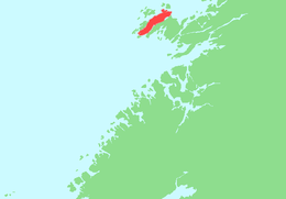 | |
 Ytter-Vikna Location of the island  Ytter-Vikna Ytter-Vikna (Norway) | |
| Geography | |
|---|---|
| Location | Trøndelag, Norway |
| Coordinates | 64°54′41″N 10°52′56″E / 64.9113°N 10.8821°ECoordinates: 64°54′41″N 10°52′56″E / 64.9113°N 10.8821°E |
| Area | 82 km2 (32 sq mi) |
| Length | 25 km (15.5 mi) |
| Width | 7 km (4.3 mi) |
| Highest elevation | 173 m (568 ft) |
| Highest point | Vattafjellet |
| Administration | |
|
Norway | |
| County | Trøndelag |
| Municipality | Vikna |
Ytter-Vikna (sometimes Ytre Vikna) is one of the three major islands in the municipality of Vikna in Trøndelag county, Norway. It is located in the western part of Vikna. Norwegian County Road 770 crosses the 82-square-kilometre (32 sq mi) island. The villages of Austafjord and Valøya are located on this island.[1]
See also
References
- ↑ Rosvold, Knut A., ed. (2017-12-25). "Vikna". Store norske leksikon (in Norwegian). Kunnskapsforlaget. Retrieved 2018-05-05.
This article is issued from
Wikipedia.
The text is licensed under Creative Commons - Attribution - Sharealike.
Additional terms may apply for the media files.