Dingalan
| Dingalan | |
|---|---|
| Municipality | |
| Municipality of Dingalan | |
|
Municipal government grounds | |
| Nickname(s): Gateway to Southern Tagalog | |
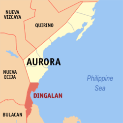 Map of Aurora with Dingalan highlighted | |
.svg.png) Dingalan Location within the Philippines | |
| Coordinates: 15°23′N 121°24′E / 15.38°N 121.4°ECoordinates: 15°23′N 121°24′E / 15.38°N 121.4°E | |
| Country |
|
| Region | Central Luzon (Region III) |
| Province | Aurora |
| District | Lone District |
| Founded | 1962 |
| Barangays |
List
|
| Government [1] | |
| • Type | Sangguniang Bayan |
| • Mayor | Sherwin Taay |
| • Electorate | 14,728 voters (2016) |
| Area [2] | |
| • Total | 304.55 km2 (117.59 sq mi) |
| Population (2015 census)[3] | |
| • Total | 25,482 |
| • Density | 84/km2 (220/sq mi) |
| Time zone | UTC+8 (PST) |
| ZIP code | 3207 |
| PSGC | 037705000 |
| IDD : area code | +63 (0)42 |
| Climate type | Tropical rainforest climate |
| Income class | 3rd municipal income class |
| Revenue (₱) | 98,629,539.07 (2016) |
| Native languages |
Umiray Dumaget language Tagalog |
| Website |
www |
Dingalan, officially the Municipality of Dingalan (Filipino: Bayan ng Dingalan; Ilokano: Ili ti Dingalan), is a municipality in the province of Aurora, Philippines. According to the 2015 census, it has a population of 25,482 people.[3]
Dingalan has several caves, of which the Lamao Caves are the best known. The rough shoreline and very high waves of Dingalan makes it attractive to surfers.
History
Dingalan, formerly just a barrio, was created a municipal district within the municipality of Baler in 1956.[4] It was declared a town in 1962.[5]
From November 30 to December 3, 2004, the town was wiped out by the tropical storms Violeta, Winnie, and Yoyong. The town benefited by relief efforts from foreign traders, some Christian groups, La Salle Greenhills, and the Philippine National Red Cross.
Due to its proximity with Aurora's capital, Dingalan has been pushing to be included in Nueva Ecija instead since the 1990s as services from Palayan City is closer.
Geography
Dingalan is located at 15°23′N 121°24′E / 15.38°N 121.4°E.
According to the Philippine Statistics Authority, the municipality has a land area of 304.55 square kilometres (117.59 sq mi) [2] constituting 9.68% of the 3,147.32-square-kilometre- (1,215.19 sq mi) total area of Aurora.
Dingalan is situated approximately 183 kilometres (114 mi) north-east of Manila. It is bounded on the north by San Luis, west by Gabaldon and General Tinio (Nueva Ecija) and Doña Remedios Trinidad (Bulacan), south by General Nakar (Quezon), and east by the Benham Rise or Plateau and Philippine Sea.
It is a small town with one main cemented road with branching alleys. Further south of the town proper are the barangays of Aplaya, Butas na Bato, Matawe, Ibona, Dikapanikian and Umiray. The premier barangay north of the town is Paltic. All of the barangays are located on the seashore, except for Poblacion and two barangays located in the mountains. The whole town is mountainous due to the Sierra Madre Mountains. The Umiray River separates the town from Quezon Province.
Barangays
Dingalan is politically subdivided into 11 barangays.[6]
| PSGC | Barangay | Population | ±% p.a. | |||
|---|---|---|---|---|---|---|
| 2015[3] | 2010[7] | |||||
| 037705001 | Aplaya | 7.1% | 1,802 | 1,619 | 2.06% | |
| 037705002 | Butas Na Bato | 3.6% | 909 | 813 | 2.15% | |
| 037705003 | Matawe (Cabog) | 13.2% | 3,356 | 3,090 | 1.58% | |
| 037705004 | Caragsacan | 11.7% | 2,992 | 2,729 | 1.77% | |
| 037705005 | Davildavilan | 4.1% | 1,036 | 992 | 0.83% | |
| 037705006 | Dikapanikian | 1.6% | 404 | 387 | 0.82% | |
| 037705007 | Ibona | 14.2% | 3,624 | 3,185 | 2.49% | |
| 037705009 | Paltic | 19.9% | 5,075 | 5,029 | 0.17% | |
| 037705010 | Poblacion | 4.3% | 1,084 | 1,091 | −0.12% | |
| 037705011 | Tanawan | 3.2% | 820 | 656 | 4.34% | |
| 037705013 | Umiray (Malamig) | 17.2% | 4,380 | 3,963 | 1.92% | |
| Total | 25,482 | 23,554 | 1.51% | |||
Demographics
| Population census of Dingalan | ||
|---|---|---|
| Year | Pop. | ±% p.a. |
| 1960 | 3,368 | — |
| 1970 | 6,616 | +6.98% |
| 1975 | 7,591 | +2.80% |
| 1980 | 8,702 | +2.77% |
| 1990 | 14,475 | +5.22% |
| 1995 | 19,325 | +5.56% |
| 2000 | 20,157 | +0.91% |
| 2007 | 21,992 | +1.21% |
| 2010 | 23,554 | +2.53% |
| 2015 | 25,482 | +1.51% |
| Source: Philippine Statistics Authority[3] [7] [8] [9] | ||
In the 2015 census, Dingalan had a population of 25,482.[3] The population density was 84 inhabitants per square kilometre (220/sq mi).
Gallery
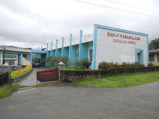 Town hall in Poblacion
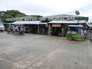 Public Market in Poblacion
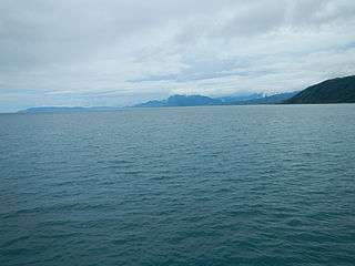 Dingalan Bay blue sea
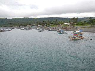 Fisherfolk at Aplaya
References
- ↑ "Municipality". Quezon City, Philippines: Department of the Interior and Local Government. Retrieved 31 May 2013.
- 1 2 "Province: Aurora". PSGC Interactive. Quezon City, Philippines: Philippine Statistics Authority. Retrieved 12 November 2016.
- 1 2 3 4 5 Census of Population (2015). "Region III (Central Luzon)". Total Population by Province, City, Municipality and Barangay. PSA. Retrieved 20 June 2016.
- ↑ "Republic Act No. 1536; An Act Creating the Municipal District of Dingalan in the Municipality of Baler, Subprovince of Aurora, Province of Quezon". The Corpus Juris. 16 June 1956. Archived from the original on 6 November 2016. Retrieved 6 November 2016.
- ↑ "Republic Act No. 3490; An Act to Convert the Municipal District of Dingalan, Subprovince of Aurora, Province of Quezon, into a Municipality". The Corpus Juris. 16 June 1962. Archived from the original on 6 November 2016. Retrieved 6 November 2016.
- ↑ "Municipal: Dingalan". PSGC Interactive. Quezon City, Philippines: Philippine Statistics Authority. Retrieved 8 January 2016.
- 1 2 Census of Population and Housing (2010). "Region III (Central Luzon)". Total Population by Province, City, Municipality and Barangay. NSO. Retrieved 29 June 2016.
- ↑ Censuses of Population (1903–2007). "Region III (Central Luzon)". Table 1. Population Enumerated in Various Censuses by Province/Highly Urbanized City: 1903 to 2007. NSO.
- ↑ "Province of Aurora". Municipality Population Data. Local Water Utilities Administration Research Division. Retrieved 17 December 2016.
External links
| Wikimedia Commons has media related to Dingalan. |
- Dingalan on Aurora.ph
Places adjacent to Dingalan | |
|---|---|
Baler (capital) | |
| Municipalities | |
| Barangays | |