Masinloc
| Masinloc | ||
|---|---|---|
| Municipality | ||
| Municipality of Masinloc | ||
.jpg) San Andres Church | ||
| ||
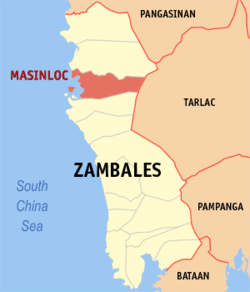
 Map of Zambales with Masinloc highlighted | ||
.svg.png) Masinloc Location within the Philippines | ||
| Coordinates: 15°32′N 119°57′E / 15.53°N 119.95°ECoordinates: 15°32′N 119°57′E / 15.53°N 119.95°E | ||
| Country |
| |
| Region | Central Luzon (Region III) | |
| Province | Zambales | |
| District | 2nd district of Zambales | |
| Founded | March 16, 1572 | |
| Barangays | 13 (see Barangays) | |
| Government [1] | ||
| • Type | Sangguniang Bayan | |
| • Mayor | Arsenia "Senyang" J. Lim | |
| • Electorate | 29,910 voters (2016) | |
| Area [2] | ||
| • Total | 331.50 km2 (127.99 sq mi) | |
| Population (2015 census)[3] | ||
| • Total | 47,719 | |
| • Density | 140/km2 (370/sq mi) | |
| Time zone | UTC+8 (PST) | |
| ZIP code | 2211 | |
| PSGC | 037106000 | |
| IDD : area code | +63 (0)47 | |
| Climate type | Tropical monsoon climate | |
| Income class | 1st municipal income class | |
| Revenue (₱) | 331,103,923.68 (2016) | |
| Native languages |
Sambal Ilocano Tagalog | |
| Website |
mymasinloc | |
Masinloc, officially the Municipality of Masinloc, is a 1st class municipality in the province of Zambales, Philippines. According to the 2015 census, it has a population of 47,719 people.[3]
The disputed Scarborough Shoal (under the names Pulo ng Panatag and Bajo de Masinlóc) is claimed by the Philippine government as within the town's territorial jurisdiction. Due to the continued dispute over the shoal, this has negatively impacted fishermen of the community, reducing catch sizes and affecting other businesses.[4]
Barangays
Demographics
| Population census of Masinloc | ||
|---|---|---|
| Year | Pop. | ±% p.a. |
| 1903 | 3,230 | — |
| 1918 | 3,905 | +1.27% |
| 1939 | 7,012 | +2.83% |
| 1948 | 8,090 | +1.60% |
| 1960 | 15,258 | +5.43% |
| 1970 | 22,736 | +4.06% |
| 1975 | 24,807 | +1.76% |
| 1980 | 27,735 | +2.26% |
| 1990 | 32,375 | +1.56% |
| 1995 | 34,942 | +1.44% |
| 2000 | 39,724 | +2.79% |
| 2007 | 40,603 | +0.30% |
| 2010 | 44,342 | +3.26% |
| 2015 | 47,719 | +1.41% |
| Source: Philippine Statistics Authority[3][5][6][7] | ||
In the 2015 census, the population of Masinloc was 47,719 people,[3] with a density of 140 inhabitants per square kilometre or 360 inhabitants per square mile.
San Andres Parish Church
Located at Brgy. South Poblacion, the 18th-century San Andres Parish Church has been declared a National Cultural Treasure by the National Museum of the Philippines in July 2001.[8]
Masinloc Coal Power Plant
An electric company producing electricity up to 600 MW. It uses coal and a steam engine attached to electric generator.
References
- ↑ "Municipality". Quezon City, Philippines: Department of the Interior and Local Government. Retrieved 31 May 2013.
- 1 2 "Province: Zambales". PSGC Interactive. Quezon City, Philippines: Philippine Statistics Authority. Retrieved 12 November 2016.
- 1 2 3 4 Census of Population (2015). "Region III (Central Luzon)". Total Population by Province, City, Municipality and Barangay. PSA. Retrieved 20 June 2016.
- ↑ Tomas Etzler (18 February 2013). "Fishermen caught out by politics of South China Sea". CNN. Retrieved 5 March 2013.
- ↑ Census of Population and Housing (2010). "Region III (Central Luzon)". Total Population by Province, City, Municipality and Barangay. NSO. Retrieved 29 June 2016.
- ↑ Censuses of Population (1903–2007). "Region III (Central Luzon)". Table 1. Population Enumerated in Various Censuses by Province/Highly Urbanized City: 1903 to 2007. NSO.
- ↑ "Province of Zambales". Municipality Population Data. Local Water Utilities Administration Research Division. Retrieved 17 December 2016.
- ↑ Alba, Reinerio. "The Restoration of 26 Philippine Churches". ncca.gov.ph. National Commission on Culture and the Arts. Archived from the original on 12 May 2014. Retrieved 26 December 2014.
External links
| Wikimedia Commons has media related to Masinloc. |
- Zambales mango remains to be sweetest, says DA official
- Philippine Standard Geographic Code
- Philippine Census Information
