Central Luzon
| Central Luzon Region III | |
|---|---|
| Region | |
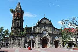
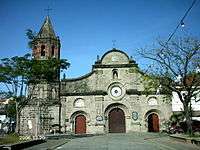   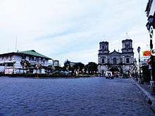  .jpg)  From top, upper-left to lower-right: Barasoain Church, Baler Bay, Sierra Madre, Angeles City, Capas National Shrine, Pinatubo Crater Lake and Mount Samat National Shrine | |
| Nickname(s): Rice Granary of the Philippines[1] | |
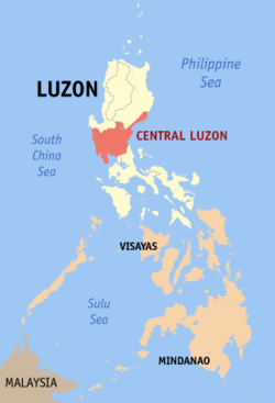 Location in the Philippines | |
| Coordinates: 15°28′N 120°45′E / 15.47°N 120.75°ECoordinates: 15°28′N 120°45′E / 15.47°N 120.75°E | |
| Country | Philippines |
| Island group | Luzon |
| Regional center | San Fernando (Pampanga)[2] |
| Area | |
| • Total | 22,014.63 km2 (8,499.90 sq mi) |
| Population (2015 census) | |
| • Total | 11,218,177 |
| • Density | 510/km2 (1,300/sq mi) |
| Time zone | UTC+8 (PST) |
| ISO 3166 code | PH-03 |
| Provinces | |
| Cities | |
| Municipalities | 116 |
| Barangays | 3,102 |
| Cong. districts | 20 |
| Languages | |
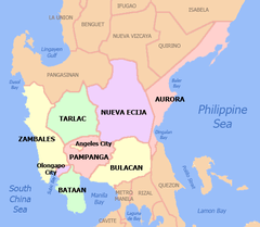
Central Luzon (Kapampangan: Kalibudtarang Luzon, Pangasinan: Pegley na Luzon, Tagalog: Gitnang Luzon, Ilokano: Tengnga a Luzon), designated as Region III, is an administrative region in the Philippines, primarily serving to organize the 7 provinces of the vast central plains of the island of Luzon (the largest island), for administrative convenience. The region contains the largest plain in the country and produces most of the country's rice supply, earning itself the nickname "Rice Granary of the Philippines".[1] Its provinces are: Aurora, Bataan, Bulacan, Nueva Ecija, Pampanga, Tarlac and Zambales.[3]
Etymology
The current name of the region is in reference to its position on Luzon island. The term was coined by American colonialists after the defeat of the First Philippine Republic. There have been proposals to rename the current Central Luzon region into the Luzones region. The proposed name is in reference to the old name of Luzon island, Luções, which was later used to refer to the central area of the island. The term Luções literally translates into Luzones.[4][5]
Overview
Central Luzon Region is located north of Manila, the nation's capital. Bordering it are the regions of Ilocos and Cagayan Valley to the north; National Capital Region, CALABARZON and the waters of Manila Bay to the south; South China Sea to the west; and the Philippine Sea to the east.[6] Pangasinan is historically and geographically a part of this region, but was politically made part of the Ilocos Region by President Ferdinand Marcos on June 22 of 1973.[7]
There are fourteen cities in the region: Balanga in Bataan; Malolos, Meycauayan and San Jose del Monte in Bulacan; Cabanatuan, Gapan, Muñoz, Palayan and San Jose in Nueva Ecija; Angeles, Mabalacat and San Fernando in Pampanga; Tarlac in Tarlac; and Olongapo in Zambales. Central Luzon produces the most rice in the whole country. Excess rice is delivered and imported to other provinces of the Philippines.[8]
The City of San Fernando, provincial capital of Pampanga, is designated as the regional center. Aurora was transferred from Region IV through Executive Order No. 103 on May 2002.[9]
Demographics
| Population census of Central Luzon | ||
|---|---|---|
| Year | Pop. | ±% p.a. |
| 1990 | 6,338,590 | — |
| 2000 | 8,204,742 | +2.61% |
| 2010 | 10,137,737 | +2.14% |
| 2015 | 11,218,177 | +1.95% |
| Source: Philippine Statistics Authority[10][11] | ||
Religion
Eighty percent of the population of Central Luzon is Roman Catholic. Other religions represented are Protestants (including Evangelicals), Islam, Iglesia Ni Cristo, and indigenous religions such as Anitism. There are also other denominations such as Jesus Is Lord, Pentecostal Missionary Church of Christ, Ang Dating Daan, Jesus Miracle Crusade, United Methodist Church and others.
Administrative divisions
Central Luzon comprises 7 provinces, 2 highly urbanized cities, 12 component cities, 116 municipalities, 3,102 barangays[12]
| Province or HUC | Capital | Population (2015)[11] | Area[13] | Density | Cities | Muni. | Bgy. | |||||
|---|---|---|---|---|---|---|---|---|---|---|---|---|
| km2 | sq mi | /km2 | /sq mi | |||||||||
| Aurora | Baler | 1.9% | 214,336 | 3,147.32 | 1,215.19 | 68 | 180 | 0 | 8 | 151 | ||
| Bataan | Balanga | 6.8% | 760,650 | 1,372.98 | 530.11 | 550 | 1,400 | 1 | 11 | 237 | ||
| Bulacan | Malolos | 29.3% | 3,292,071 | 2,796.10 | 1,079.58 | 1,200 | 3,100 | 3 | 21 | 569 | ||
| Nueva Ecija | Palayan | 19.2% | 2,151,461 | 5,751.33 | 2,220.60 | 370 | 960 | 5 | 27 | 849 | ||
| Pampanga | San Fernando | 19.6% | 2,198,110 | 2,002.20 | 773.05 | 1,100 | 2,800 | 2 | 19 | 505 | ||
| Tarlac | Tarlac City | 12.2% | 1,366,027 | 3,053.60 | 1,179.00 | 450 | 1,200 | 1 | 17 | 511 | ||
| Zambales | Iba | 5.3% | 590,848 | 3,645.83 | 1,407.66 | 160 | 410 | 0 | 13 | 230 | ||
| Angeles | † | — | 3.7% | 411,634 | 60.27 | 23.27 | 6,800 | 18,000 | — | — | 33 | |
| Olongapo | † | — | 2.1% | 233,040 | 185.00 | 71.43 | 1,300 | 3,400 | — | — | 17 | |
| Total | 11,218,177 | 22,014.63 | 8,499.90 | 510 | 1,300 | 14 | 116 | 3,102 | ||||
|
† Angeles and Olongapo are highly-urbanized cities; figures are excluded from Pampanga and Zambales respectively. | ||||||||||||
Cities
The Central Luzon Region has fourteen cities. San Jose del Monte is the city with the most population while Angeles is the most densely populated city in the region. Tarlac City is the largest based on land area.
| City | Population (2015)[11] | Area[14] | Density | City class | Income class | Province | ||
|---|---|---|---|---|---|---|---|---|
| Angeles | 411,634 | 60.27 | 23.27 | 6,800 | 18,000 | Highly Urbanized | 1st | Pampanga |
| Balanga | 96,061 | 111.63 | 43.10 | 860 | 2,200 | Component | 4th | Bataan |
| Cabanatuan | 302,231 | 192.29 | 74.24 | 1,600 | 4,100 | Component | 1st | Nueva Ecija |
| Gapan | 110,303 | 164.44 | 63.49 | 670 | 1,700 | Component | 4th | Nueva Ecija |
| Mabalacat | 250,799 | 83.18 | 32.12 | 3,000 | 7,800 | Component | 1st | Pampanga |
| Malolos | 252,074 | 67.25 | 25.97 | 3,700 | 9,600 | Component | 1st | Bulacan |
| Meycauayan | 209,083 | 32.10 | 12.39 | 6,500 | 17,000 | Component | 1st | Bulacan |
| Muñoz | 81,483 | 163.05 | 62.95 | 500 | 1,300 | Component | 4th | Nueva Ecija |
| Olongapo | 233,040 | 185.00 | 71.43 | 1,300 | 3,400 | Highly Urbanized | 1st | Zambales |
| Palayan | 41,041 | 101.40 | 39.15 | 400 | 1,000 | Component | 5th | Nueva Ecija |
| San Fernando | 306,659 | 67.74 | 26.15 | 4,500 | 12,000 | Component | 1st | Pampanga |
| San Jose | 139,738 | 185.99 | 71.81 | 750 | 1,900 | Component | 2nd | Nueva Ecija |
| San Jose del Monte | 574,089 | 105.53 | 40.75 | 5,400 | 14,000 | Component | 1st | Bulacan |
| Tarlac City | 342,493 | 274.66 | 106.05 | 1,200 | 3,100 | Component | 1st | Tarlac |
Gallery


.jpg)


.jpg)


See also
References
- 1 2 Edenhofer, Ottmar; Wallacher, Johannes; Lotze-Campen, Hermann; Reder, Michael; Knopf, Brigitte; Müller, Johannes (2012-06-25). Climate Change, Justice and Sustainability: Linking Climate and Development Policy. Springer Science & Business Media. p. 206. ISBN 9789400745407.
- ↑ "DILG Region 3 - Regional Management". Department of the Interior and Local Government. Retrieved May 29, 2016.
- ↑ "Central Luzon, Region III, Philippines". flagspot.net.
- ↑ http://opinion.inquirer.net/95645/change-name-will-good-philippines
- ↑ http://news.abs-cbn.com/news/06/13/17/should-the-philippines-be-renamed-historian-weighs-in
- ↑ "Region III, Central Luzon, Geographical Location". evis.net.ph.
- ↑ "Presidential Decree № 224". Retrieved November 5, 2016.
- ↑ "REGION III (Central Luzon)". National Statistical Coordination Board. Archived from the original on 2012-11-14. Retrieved 2016-09-07.
- ↑ "Executive Order No. 103; Dividing Region IV into Region IV-A and Region IV-B, Transferring the Province of Aurora to Region III and for Other Purposes". Philippine Statistics Authority. 17 May 2002. Archived from the original on 18 May 2016. Retrieved 29 March 2016.
SECTION 4. The Province of Aurora is hereby transferred to and shall form part of Region III.
- ↑ "Population and Annual Growth Rates for The Philippines and Its Regions, Provinces, and Highly Urbanized Cities" (PDF). 2010 Census and Housing Population. Philippine Statistics Authority. Archived from the original (PDF) on 28 September 2013. Retrieved 9 August 2013.
- 1 2 3 Census of Population (2015). Highlights of the Philippine Population 2015 Census of Population. PSA. Retrieved 20 June 2016.
- ↑ "List of Regions". National Statistical Coordination Board. Archived from the original on 27 October 2008. Retrieved 9 January 2011.
- ↑ "PSGC Interactive; List of Provinces". Philippine Statistics Authority. Archived from the original on 21 January 2013. Retrieved 29 March 2016.
- ↑ "PSGC Interactive; List of Cities". Philippine Statistics Authority. Archived from the original on 29 April 2011. Retrieved 29 March 2016.
External links
| Wikimedia Commons has media related to Central Luzon. |
| Wikivoyage has a travel guide for Central Luzon. |
- Central Luzon Local Search
- North Luzon Super Region: Potentials
- North Luzon Super Region: Projects
- Executive Order No. 103
Places adjacent to Central Luzon | |
|---|---|

