Dinalupihan, Bataan
| Dinalupihan | ||
|---|---|---|
| Municipality | ||
| Municipality of Dinalupihan | ||
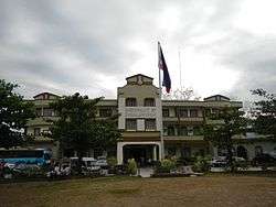 Municipal Hall | ||
| ||
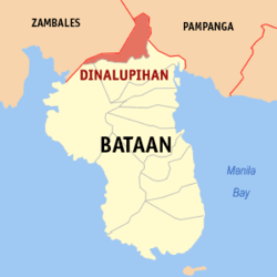 Map of Bataan with Dinalupihan highlighted | ||
.svg.png) Dinalupihan Location within the Philippines | ||
| Coordinates: 14°53′N 120°28′E / 14.88°N 120.47°ECoordinates: 14°53′N 120°28′E / 14.88°N 120.47°E | ||
| Country |
| |
| Region | Central Luzon (Region III) | |
| Province | Bataan | |
| District | 1st District | |
| Founded | 1865 | |
| Barangays | 47 (see Barangays) | |
| Government [1] | ||
| • Type | Sangguniang Bayan | |
| • Mayor | Gila Garcia | |
| • Vice Mayor | Renato Matawaran | |
| • Electorate | 62,848 voters (2016) | |
| Area [2] | ||
| • Total | 92.52 km2 (35.72 sq mi) | |
| Population (2015 census)[3] | ||
| • Total | 106,371 | |
| • Density | 1,100/km2 (3,000/sq mi) | |
| Time zone | UTC+8 (PST) | |
| ZIP code | 2110 | |
| PSGC | 030804000 | |
| IDD : area code | +63 (0)47 | |
| Climate type | Tropical monsoon climate | |
| Income class | 1st municipal income class | |
| Revenue (₱) | 242,291,407.11 (2016) | |
| Native languages |
Mariveleño Kapampangan Ambala language Tagalog | |
| Website |
www | |

Dinalupihan, officially the Municipality of Dinalupihan, (Filipino: Bayan ng Dinalupihan; Kapampangan: Balen ning Dinalupihan), is a 1st class municipality in the province of Bataan, Philippines. According to the 2015 census, it has a population of 106,371 people.[3]
It is the only landlocked town of the province.
Dinalupihan is accessible via the Bataan Provincial Expressway, off Exit 5.
Etymology
"Dinalupijan" came from the festival rights of "Aeta" pygmies. To commemorate their idol "Indianalo", the goddess of hunting and bountiful harvest."Indianalo" was paired with the Sanskrit word "jann", meaning paradise. "Indianalopijann" was the name given to the land that the "Aetas" received from their goddess which translates to Indianalo's paradise.[4] As time progresses, the name "Indianalopijann" turned into "Dinalupihan".
The name "Dinalupihan" also means "empty lands", coming from the Spanish terms din, a, and lupia. It referred to the fact that it failed to produce little revenue while it was an estate of the Archdiocese of Manila during the second half of the 18th century.[5]
Geography
Dinalupihan is located at 14°53′N 120°28′E / 14.88°N 120.47°E.
According to the Philippine Statistics Authority, the municipality has a land area of 92.52 square kilometres (35.72 sq mi) [2] constituting 6.74% of the 1,372.98-square-kilometre- (530.11 sq mi) total area of Bataan.
Barangays
Dinalupihan is politically subdivided into 46 barangays.[6]
| PSGC | Barangay | Population | ±% p.a. | |||
|---|---|---|---|---|---|---|
| 2015[3] | 2010[7] | |||||
| 030804044 | Aquino | 0.1% | 95 | 111 | −2.92% | |
| 030804002 | Bangal | 4.5% | 4,774 | 4,415 | 1.50% | |
| 030804045 | Bayan‑bayanan | 0.7% | 728 | 447 | 9.73% | |
| 030804003 | Bonifacio (Poblacion) | 0.5% | 488 | 505 | −0.65% | |
| 030804006 | Burgos (Poblacion) | 0.4% | 411 | 465 | −2.32% | |
| 030804007 | Colo | 2.9% | 3,135 | 2,986 | 0.93% | |
| 030804008 | Daang Bago | 2.7% | 2,822 | 2,939 | −0.77% | |
| 030804009 | Dalao | 1.5% | 1,573 | 1,303 | 3.65% | |
| 030804010 | Del Pilar (Poblacion) | 0.3% | 291 | 271 | 1.36% | |
| 030804011 | Gen. Luna (Poblacion) | 0.6% | 608 | 585 | 0.74% | |
| 030804012 | Gomez (Poblacion) | 0.3% | 292 | 324 | −1.96% | |
| 030804013 | Happy Valley | 1.6% | 1,744 | 1,704 | 0.44% | |
| 030804050 | Jose C. Payumo, Jr. | 3.2% | 3,360 | 3,114 | 1.46% | |
| 030804014 | Kataasan | 2.8% | 2,990 | 3,015 | −0.16% | |
| 030804015 | Layac | 1.3% | 1,416 | 1,339 | 1.07% | |
| 030804016 | Luacan | 5.8% | 6,184 | 5,779 | 1.30% | |
| 030804018 | Mabini Ext. (Poblacion) | 0.7% | 703 | 734 | −0.82% | |
| 030804017 | Mabini Proper (Poblacion) | 0.3% | 324 | 339 | −0.86% | |
| 030804019 | Magsaysay | 1.6% | 1,737 | 1,871 | −1.40% | |
| 030804046 | Maligaya | 1.5% | 1,565 | 1,372 | 2.54% | |
| 030804020 | Naparing | 2.5% | 2,705 | 2,500 | 1.51% | |
| 030804021 | New San Jose | 5.7% | 6,012 | 6,030 | −0.06% | |
| 030804022 | Old San Jose | 2.3% | 2,421 | 2,002 | 3.68% | |
| 030804023 | Padre Dandan (Poblacion) | 0.1% | 159 | 155 | 0.49% | |
| 030804024 | Pag‑asa | 1.9% | 1,981 | 2,020 | −0.37% | |
| 030804025 | Pagalanggang | 3.7% | 3,931 | 3,512 | 2.17% | |
| 030804047 | Payangan | 0.7% | 770 | 554 | 6.47% | |
| 030804048 | Pentor | 2.9% | 3,041 | 2,934 | 0.68% | |
| 030804026 | Pinulot | 3.9% | 4,159 | 3,563 | 2.99% | |
| 030804027 | Pita | 3.4% | 3,578 | 3,513 | 0.35% | |
| 030804029 | Rizal (Poblacion) | 0.2% | 249 | 255 | −0.45% | |
| 030804030 | Roosevelt | 8.5% | 9,032 | 8,721 | 0.67% | |
| 030804031 | Roxas (Poblacion) | 0.3% | 293 | 347 | −3.17% | |
| 030804032 | Saguing | 4.2% | 4,455 | 3,964 | 2.25% | |
| 030804033 | San Benito | 2.6% | 2,739 | 2,394 | 2.60% | |
| 030804034 | San Isidro (Poblacion) | 0.9% | 983 | 1,047 | −1.19% | |
| 030804035 | San Pablo (Bulate) | 5.6% | 5,942 | 3,736 | 9.24% | |
| 030804036 | San Ramon | 3.7% | 3,904 | 3,707 | 0.99% | |
| 030804037 | San Simon | 1.7% | 1,800 | 1,278 | 6.74% | |
| 030804040 | Santa Isabel (Tabacan) | 2.3% | 2,412 | 2,190 | 1.86% | |
| 030804038 | Santo Niño | 3.0% | 3,190 | 3,066 | 0.76% | |
| 030804039 | Sapang Balas | 1.2% | 1,271 | 942 | 5.87% | |
| 030804041 | Torres Bugauen (Poblacion) | 0.9% | 915 | 862 | 1.14% | |
| 030804049 | Tubo‑tubo | 0.5% | 549 | 342 | 9.43% | |
| 030804042 | Tucop | 4.0% | 4,284 | 3,686 | 2.90% | |
| 030804043 | Zamora (Poblacion) | 0.3% | 356 | 337 | 1.05% | |
| Total | 106,371 | 97,275 | 1.72% | |||
Demographics
| Population census of Dinalupihan | ||
|---|---|---|
| Year | Pop. | ±% p.a. |
| 1903 | 3,028 | — |
| 1918 | 4,319 | +2.40% |
| 1939 | 8,821 | +3.46% |
| 1948 | 14,341 | +5.55% |
| 1960 | 21,249 | +3.33% |
| 1970 | 30,509 | +3.68% |
| 1975 | 36,302 | +3.55% |
| 1980 | 41,415 | +2.67% |
| 1990 | 58,172 | +3.46% |
| 1995 | 65,159 | +2.15% |
| 2000 | 76,145 | +3.40% |
| 2007 | 92,289 | +2.69% |
| 2010 | 97,275 | +1.93% |
| 2015 | 106,371 | +1.72% |
| Source: Philippine Statistics Authority[3] [7] [8] [9] | ||
In the 2015 census, Dinalupihan had a population of 106,371.[3] The population density was 1,100 inhabitants per square kilometre (2,800/sq mi).
Government
Pursuant to the Local government in the Philippines",[10][11] the political seat of the municipal government is located at the Municipal Town Hall. In the History of the Philippines (1521–1898), the Gobernadorcillo was the Chief Executive who held office in the Presidencia. During the American rule (1898–1946) (History of the Philippines (1898-1946)), the elected Mayor and local officials, including the appointed ones hold office at the Municipal Town Hall. The legislative and executive departments perform their functions in the Sangguniang Bayan (Session Hall) and Municipal Trial Court, respectively, and are located in the Town Hall.
Dinalupihan, Bataan's incumbent Mayor is Gila Garcia (NUP) and the Vice Mayor is Renato Matawaran (AKSYON).
Sangguniang Bayan Members are: Ricardo De Ausen, Martin Tongol Jr., Danny Dela Cruz, Rolly Buniag, Amy Sandoval, Zaldy Torno, Maning Inza Cruz, Arnold Soriano, ABC Armando Buniag and SK Ernest Estanislao.[12]
Attractions
Dinalupihan's interesting points, landmarks and festivals, are:
- Battle of Bataan, Layac Junction marker
- World War II First Line of Defense Memorial (Battle of Bataan - Battle of Layac Junction, January 6, 1942)
- 38th Infantry Division (United States) marker, Layac Junction
- Roosevelt Protected Landscape, also known as Roosevelt Park, is the location shooting of Enchanted Garden
- Town Hall
- Bataan Peninsula State University, Dinalupihan campus
- Bataan Peninsula Medical Center
- 1960 Saint John Academy
- Glorrieta, open auditorium, grandstand, park and plaza
- Dinalupihan Civic Center
- Memorial, Monument of Dinalupihan heroes (Marcela Rodriguez)
- Heaven's Garden Memorial Park
- Dinalupihan Memorial Park
- Mount Malasimbo
- Tubig Festival (June 24)
- La Vercons Bakeshop
- WorkOut WorX Fitness Center
- Sweet Momc's Cake
- Boom's Cold Brew Coffee
- Net Embassy
Saint John the Baptist Parish Church
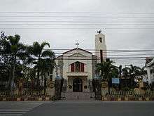
Saint John the Baptist Parish Church (in Poblacion) belongs to the Roman Catholic Diocese of Balanga[13] (Dioecesis Balangensis) Suffragan of San Fernando, Pampanga Created: March 17, 1975. Canonically Erected: November 7, 1975. Comprises the whole civil province of Bataan. Titular: St. Joseph, Husband of Mary, April 28. Bishop Most Reverend Ruperto Cruz Santos, DD).[14][15][16]
Its Feast day is June 24. It is under the Vicariate of Saint Peter of Verona I - Vicariate of Our Lady, Mirror of Justice.[15][17] The Catholic population is about 25,438.[18]
Notable people
- Gary David — PBA multi-awarded player
- Chito Jaime — PBA player
- Jackie Rice — Filipina actress who won the title of Ultimate Female Survivor on the third season of Startstruck.
- Felicito Payumo — Chairman of the Subic Bay Metropolitan Authority from 1998-2004.
- Agalub Tae
- Confuse - First 3kMMR Pinoy from Brgy. Pita.
- Ako si Christoper - Hottie from Brgy San Jose
- Paktoy - Pakboy na totoy
- Renz Serrano - Matalino, kabisado ang lesson, 'di nagrereview.
Gallery
 Welcome arch of Dinalupihan Park and Plaza
 World War II First Line of Defense Memorial (Battle of Bataan - Battle of Layac Junction, January 6, 1942)
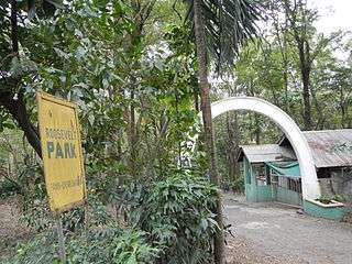 Roosevelt Park is the location shooting of Enchanted Garden
 Bataan Peninsula Medical Center
 Dinalupihan Civic Center
 Elementary school
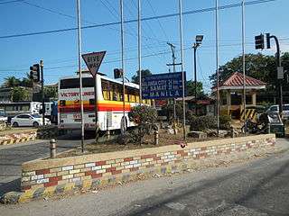 Layac Junction
References
- ↑ "Municipality". Quezon City, Philippines: Department of the Interior and Local Government. Retrieved 31 May 2013.
- 1 2 "Province: Bataan". PSGC Interactive. Quezon City, Philippines: Philippine Statistics Authority. Retrieved 12 November 2016.
- 1 2 3 4 5 Census of Population (2015). "Region III (Central Luzon)". Total Population by Province, City, Municipality and Barangay. PSA. Retrieved 20 June 2016.
- ↑ Reyes, Jose. "Chief of Police, Former". History of Bataan. 1.
- ↑ Jason (28 September 2009). "Dinalupihan History". Municipality of Dinalupihan. Archived from the original on 5 October 2010. Retrieved 13 February 2013.
- ↑ "Municipal: Dinalupihan, Bataan". PSGC Interactive. Quezon City, Philippines: Philippine Statistics Authority. Retrieved 8 January 2016.
- 1 2 Census of Population and Housing (2010). "Region III (Central Luzon)". Total Population by Province, City, Municipality and Barangay. NSO. Retrieved 29 June 2016.
- ↑ Censuses of Population (1903–2007). "Region III (Central Luzon)". Table 1. Population Enumerated in Various Censuses by Province/Highly Urbanized City: 1903 to 2007. NSO.
- ↑ "Province of Bataan". Municipality Population Data. Local Water Utilities Administration Research Division. Retrieved 17 December 2016.
- ↑ "Philippines : Gov.Ph : About the Philippines :". Gov.ph. Archived from the original on 2009-01-22. Retrieved 2009-03-28.
- ↑ "The Local Government Code Of The Philippines - Chan Robles Virtual Law Library". Chanrobles.com. Retrieved 2016-11-11.
- ↑
- ↑ "ParishesV1". Balangadiocese.com. Retrieved 2016-11-11.
- ↑ "List of Parishes of the Roman Catholic Diocese of Balanga | Philippine Churches". Church.nfo.ph. 2012-06-27. Archived from the original on 2016-03-03. Retrieved 2016-11-11.
- 1 2 "Parishes". Cbcponline.net. Retrieved 2016-11-11.
- ↑ "Department of Tourism - The Philippines Ultimate Travel Guide for Tourist". Visitmyphilippines.com. Retrieved 2016-11-11.
- ↑ "Archived copy". Archived from the original on 2012-09-06. Retrieved 2013-01-27.
- ↑ "Archived copy". Archived from the original on 2014-05-17. Retrieved 2013-01-27.
External links
| Wikimedia Commons has media related to Dinalupihan, Bataan. |
- Dinalupihan Bataan General Information on MyBataan
Places adjacent to Dinalupihan, Bataan | ||||||||||
|---|---|---|---|---|---|---|---|---|---|---|
| ||||||||||