Victoria, Tarlac
| Victoria | ||
|---|---|---|
| Municipality | ||
| Municipality of Victoria | ||
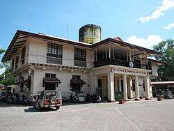 Municipal Hall | ||
| ||
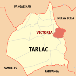 Map of Tarlac with Victoria highlighted | ||
.svg.png) Victoria Location within the Philippines | ||
| Coordinates: 15°34′41″N 120°40′55″E / 15.5781°N 120.6819°ECoordinates: 15°34′41″N 120°40′55″E / 15.5781°N 120.6819°E | ||
| Country |
| |
| Region | Central Luzon (Region III) | |
| Province | Tarlac | |
| District | 2nd District | |
| Founded | March 28, 1855 | |
| Barangays | 26 (see Barangays) | |
| Government [1] | ||
| • Type | Sangguniang Bayan | |
| • Mayor | Marvin Silao | |
| • Electorate | 34,740 voters (2016) | |
| Area [2] | ||
| • Total | 111.51 km2 (43.05 sq mi) | |
| Population (2015 census)[3] | ||
| • Total | 63,715 | |
| • Density | 570/km2 (1,500/sq mi) | |
| Time zone | UTC+8 (PST) | |
| ZIP code | 2313 | |
| PSGC | 036917000 | |
| IDD : area code | +63 (0)45 | |
| Climate type | Tropical monsoon climate | |
| Income class | 2nd municipal income class | |
| Revenue (₱) | 140,083,083.05 (2016) | |
| Native languages |
Kapampangan Tagalog | |
| Website |
www | |

Victoria, officially the Municipality of Victoria, is a 2nd class municipality in the province of Tarlac, Philippines. According to the 2015 census, it has a population of 63,715 people.[3]
The municipality is located in the Province of Tarlac, geographically located in the central part of Luzon. It lies between 1"42’ north latitude and 120º35’ and 120"45 east longitude. It is bounded by Tarlac City, municipalities of Pura Gerona, La Paz and to the east by the Province of Nueva Ecija. The municipality has a total land area of 11,150 hectares, of which a large portion is used for agricultural activities.
The establishment of Victoria as a community may be traced back in the mid 1800’s when the Spanish regime started to expand north from Manila. It almost happened at the same time when Porac and Florida Blanca (now part of Pampanga) and Tarlac (now Tarlac city) were formed. In the mid 1800’s people started to settle around the swamp or wetland in search for a place where food is abundant. By 1849 houses and pockets of communities were deriving subsistence from the wetland. The biggest sitio was Namitinan which became part of the earliest barrio formed in 1852 called San Vicente de Canarum. The name was derived from the wetland called Canarum Lake. Not until the signing of the decree by the Spanish Governor General Manuel Crespo on March 28, 1855, that the barrio San Vicente de Canarum was separated from Tarlac to form an independent pueblo named Victoria. The name was used to highlight the victorious battle of the faithful followers of Queen Isabela of Spain over their European enemies.
Traces of its Spanish history may still be seen in the well preserved municipal building, several old houses depicting Spanish architecture and various edifices that were built more than a hundred years ago.
Barangays
Victoria is politically subdivided into 26 barangays. [2]
- Baculong
- Balayang
- Balbaloto
- Bangar
- Bantog
- Batang-batang
- Bulo (Poblacion)
- Cabuluan
- Calibungan
- Canarem
- Cruz
- Lalapac
- Maluid
- Mangolago
- Masalasa
- Palac-palac
- San Agustin
- San Andres
- San Fernando (Poblacion)
- San Francisco
- San Gavino (Poblacion)
- San Jacinto
- San Nicolas (Poblacion)
- San Vicente (Poblacion)
- Santa Barbara (Poblacion)
- Santa Lucia (Poblacion)
Demographics
| Population census of Victoria | ||
|---|---|---|
| Year | Pop. | ±% p.a. |
| 1903 | 14,945 | — |
| 1918 | 15,661 | +0.31% |
| 1939 | 19,575 | +1.07% |
| 1948 | 24,398 | +2.48% |
| 1960 | 26,555 | +0.71% |
| 1970 | 33,141 | +2.24% |
| 1975 | 34,889 | +1.04% |
| 1980 | 34,942 | +0.03% |
| 1990 | 42,360 | +1.94% |
| 1995 | 47,546 | +2.19% |
| 2000 | 50,930 | +1.48% |
| 2007 | 57,085 | +1.59% |
| 2010 | 59,987 | +1.82% |
| 2015 | 63,715 | +1.15% |
| Source: Philippine Statistics Authority[3][4][5][6] | ||
In the 2015 census, the population of Victoria, Tarlac, was 63,715 people,[3] with a density of 570 inhabitants per square kilometre or 1,500 inhabitants per square mile.
References
- ↑ "Municipality". Quezon City, Philippines: Department of the Interior and Local Government. Retrieved 31 May 2013.
- 1 2 "Province: Tarlac". PSGC Interactive. Quezon City, Philippines: Philippine Statistics Authority. Retrieved 12 November 2016.
- 1 2 3 4 Census of Population (2015). "Region III (Central Luzon)". Total Population by Province, City, Municipality and Barangay. PSA. Retrieved 20 June 2016.
- ↑ Census of Population and Housing (2010). "Region III (Central Luzon)". Total Population by Province, City, Municipality and Barangay. NSO. Retrieved 29 June 2016.
- ↑ Censuses of Population (1903–2007). "Region III (Central Luzon)". Table 1. Population Enumerated in Various Censuses by Province/Highly Urbanized City: 1903 to 2007. NSO.
- ↑ "Province of Tarlac". Municipality Population Data. Local Water Utilities Administration Research Division. Retrieved 17 December 2016.
External links
| Wikimedia Commons has media related to Victoria, Tarlac. |
Places adjacent to Victoria, Tarlac | |
|---|---|
Tarlac City (capital) | |
| Municipalities | |
| Component city | |
| Barangays | |