Dipaculao, Aurora
| Dipaculao | |
|---|---|
| Municipality | |
| Municipality of Dipaculao | |
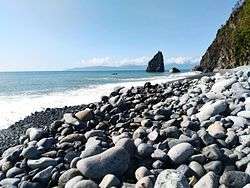 Ampere Beach and Ampere Rock in Dipaculao | |
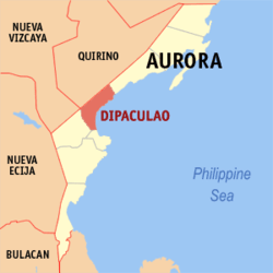 Map of Aurora with Dipaculao highlighted | |
.svg.png) Dipaculao Location within the Philippines | |
| Coordinates: 15°59′N 121°38′E / 15.98°N 121.63°ECoordinates: 15°59′N 121°38′E / 15.98°N 121.63°E | |
| Country |
|
| Region | Central Luzon (Region III) |
| Province | Aurora |
| District | Lone District |
| Founded | 1950 |
| Barangays |
List
|
| Government [1] | |
| • Type | Sangguniang Bayan |
| • Mayor | Joanna Wilma Cabauatan Salamanca |
| • Electorate | 17,722 voters (2016) |
| Area [2] | |
| • Total | 361.64 km2 (139.63 sq mi) |
| Population (2015 census)[3] | |
| • Total | 29,736 |
| • Density | 82/km2 (210/sq mi) |
| Time zone | UTC+8 (PST) |
| ZIP code | 3203 |
| PSGC | 037706000 |
| IDD : area code | +63 (0)42 |
| Climate type | Tropical rainforest climate |
| Income class | 3rd municipal income class |
| Revenue (₱) | 115,086,349.16 (2016) |
| Native languages |
Ilocano Tagalog |
| Website |
www |
Dipaculao, officially the Municipality of Dipaculao (Filipino: Bayan ng Dipaculao; Ilokano: Ili ti Dipaculao), is a municipality in the province of Aurora, Philippines. According to the 2015 census, it has a population of 29,736 people.[3]
The municipality is home to the Dinadiawan River Protected Landscape.
History
On June 21, 1957 the sitios of Dimabono, Laboy, Dinadiawan and Puangi were converted into barrios.[4][5][6][7] Several more sitios were converted into barrios on June 18, 1966.[8]
Geography
Dipaculao is located at 15°59′N 121°38′E / 15.98°N 121.63°E.
According to the Philippine Statistics Authority, the municipality has a land area of 361.64 square kilometres (139.63 sq mi) [2] constituting 11.49% of the 3,147.32-square-kilometre- (1,215.19 sq mi) total area of Aurora.
Barangays
Dipaculao is politically subdivided into 25 barangays.[9]
| PSGC | Barangay | Population | ±% p.a. | |||
|---|---|---|---|---|---|---|
| 2015[3] | 2010[10] | |||||
| 037706001 | Bayabas | 3.1% | 915 | 914 | 0.02% | |
| 037706003 | Borlongan | 8.1% | 2,416 | 2,173 | 2.04% | |
| 037706002 | Buenavista | 1.9% | 569 | 554 | 0.51% | |
| 037706004 | Calaocan | 2.7% | 816 | 873 | −1.28% | |
| 037706025 | Diamanen | 1.1% | 331 | 172 | 13.27% | |
| 037706005 | Dianed | 2.4% | 722 | 588 | 3.99% | |
| 037706006 | Diarabasin | 5.8% | 1,730 | 1,621 | 1.25% | |
| 037706007 | Dibutunan | 2.9% | 860 | 723 | 3.36% | |
| 037706008 | Dimabuno | 4.0% | 1,195 | 1,023 | 3.00% | |
| 037706009 | Dinadiawan | 12.6% | 3,733 | 3,670 | 0.32% | |
| 037706010 | Ditale | 4.7% | 1,398 | 1,297 | 1.44% | |
| 037706011 | Gupa | 3.5% | 1,037 | 991 | 0.87% | |
| 037706012 | Ipil | 3.9% | 1,154 | 1,149 | 0.08% | |
| 037706013 | Laboy | 1.5% | 454 | 404 | 2.25% | |
| 037706014 | Lipit | 3.3% | 968 | 818 | 3.26% | |
| 037706015 | Lobbot | 2.0% | 580 | 475 | 3.88% | |
| 037706016 | Maligaya | 2.2% | 665 | 574 | 2.84% | |
| 037706017 | Mijares | 3.8% | 1,134 | 1,014 | 2.15% | |
| 037706018 | Mucdol | 5.0% | 1,479 | 1,476 | 0.04% | |
| 037706019 | North Poblacion | 6.9% | 2,059 | 2,058 | 0.01% | |
| 037706020 | Puangi | 4.8% | 1,430 | 1,314 | 1.62% | |
| 037706021 | Salay | 4.8% | 1,417 | 1,323 | 1.32% | |
| 037706022 | Sapangkawayan | 1.4% | 405 | 349 | 2.87% | |
| 037706023 | South Poblacion | 5.7% | 1,693 | 1,688 | 0.06% | |
| 037706024 | Toytoyan | 1.9% | 576 | 488 | 3.21% | |
| Total | 29,736 | 27,729 | 1.34% | |||
Demographics
| Population census of Dipaculao | ||
|---|---|---|
| Year | Pop. | ±% p.a. |
| 1960 | 5,149 | — |
| 1970 | 10,228 | +7.10% |
| 1975 | 12,702 | +4.44% |
| 1980 | 15,561 | +4.14% |
| 1990 | 18,951 | +1.99% |
| 1995 | 21,044 | +1.98% |
| 2000 | 23,064 | +1.98% |
| 2007 | 24,882 | +1.05% |
| 2010 | 27,729 | +4.02% |
| 2015 | 29,736 | +1.34% |
| Source: Philippine Statistics Authority[3] [10] [11] [12] | ||
In the 2015 census, Dipaculao had a population of 29,736.[3] The population density was 82 inhabitants per square kilometre (210/sq mi).
Gallery
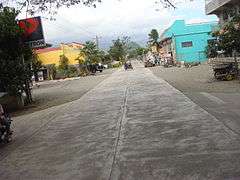 South Poblacion
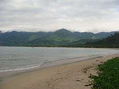 Dinadiawan white beach (a long stretch of clean, fine, golden white sand coastline)
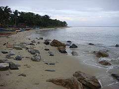 Rock formations along the shoreline (north of Baler along the Dicadi highway)
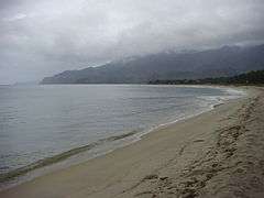 White sand beaches
References
- ↑ "Municipality". Quezon City, Philippines: Department of the Interior and Local Government. Retrieved 31 May 2013.
- 1 2 "Province: Aurora". PSGC Interactive. Quezon City, Philippines: Philippine Statistics Authority. Retrieved 12 November 2016.
- 1 2 3 4 5 Census of Population (2015). "Region III (Central Luzon)". Total Population by Province, City, Municipality and Barangay. PSA. Retrieved 20 June 2016.
- ↑ "Republic Act No. 1761; An Act Creating the Barrio of Laboy in the Municipality of Dipaculao, Province of Quezon". PhilippineLaw.info. 21 June 1957. Archived from the original on 15 May 2012. Retrieved 6 November 2016.
- ↑ "Republic Act No. 1762; An Act Creating the Barrio of Dinadiawan in the Municipality of Dipaculao, Province of Quezon". PhilippineLaw.info. 21 June 1957. Archived from the original on 15 May 2012. Retrieved 6 November 2016.
- ↑ "Republic Act No. 1763; An Act Creating the Barrio of Puangi in the Municipality of Dipaculao, Province of Quezon". PhilippineLaw.info. 21 June 1957. Archived from the original on 15 May 2012. Retrieved 6 November 2016.
- ↑ "Republic Act No. 1764; An Act Creating the Barrio of Dimabono in the Municipality of Dipaculao, Province of Quezon". PhilippineLaw.info. 21 June 1957. Archived from the original on 15 May 2012. Retrieved 6 November 2016.
- ↑ "Republic Act No. 4809; Republic Act No. 4809 - An Act Creating Certain Barrios in the Municipalities of Dipaculao and San Luis and the Municipal District of Dilasag, Province of Quezon". Chan Robles Virtual Law Library. 18 June 1966. Archived from the original on 25 September 2013. Retrieved 6 November 2016.
- ↑ "Municipal: Dipaculao, Aurora". PSGC Interactive. Quezon City, Philippines: Philippine Statistics Authority. Retrieved 8 January 2016.
- 1 2 Census of Population and Housing (2010). "Region III (Central Luzon)". Total Population by Province, City, Municipality and Barangay. NSO. Retrieved 29 June 2016.
- ↑ Censuses of Population (1903–2007). "Region III (Central Luzon)". Table 1. Population Enumerated in Various Censuses by Province/Highly Urbanized City: 1903 to 2007. NSO.
- ↑ "Province of Aurora". Municipality Population Data. Local Water Utilities Administration Research Division. Retrieved 17 December 2016.
External links
| Wikimedia Commons has media related to Dipaculao, Aurora. |
- Dipaculao on Aurora.ph
Places adjacent to Dipaculao, Aurora | |
|---|---|
Baler (capital) | |
| Municipalities | |
| Barangays | |