Morong, Bataan
| Morong | ||
|---|---|---|
| Municipality | ||
| Municipality of Morong | ||
 Downtown area | ||
| ||
| Nickname(s): Bataan's Wild West | ||
 Map of Bataan with Morong highlighted | ||
.svg.png) Morong Location within the Philippines | ||
| Coordinates: 14°41′N 120°16′E / 14.68°N 120.27°ECoordinates: 14°41′N 120°16′E / 14.68°N 120.27°E | ||
| Country |
| |
| Region | Central Luzon (Region III) | |
| Province | Bataan | |
| District | 1st District of Bataan | |
| Barangays | 5 (see Barangays) | |
| Government [1] | ||
| • Type | Sangguniang Bayan | |
| • Mayor | Cynthia L. Estanislao | |
| • Vice Mayor | Bienvenido V. Vicedo Jr. | |
| • Electorate | 18,795 voters (2016) | |
| Area [2] | ||
| • Total | 219.20 km2 (84.63 sq mi) | |
| Population (2015 census)[3] | ||
| • Total | 29,901 | |
| • Density | 140/km2 (350/sq mi) | |
| Time zone | UTC+8 (PST) | |
| ZIP code | 2108 | |
| PSGC | 030808000 | |
| IDD : area code | +63 (0)47 | |
| Climate type | Tropical monsoon climate | |
| Income class | 3rd municipal income class | |
| Revenue (₱) | 120,865,448.71 (2016) | |
| Native languages |
Mariveleño Tagalog | |

Morong, officially the Municipality of Morong, (Filipino: Bayan ng Morong; Kapampangan: Balen ning Morong), is a 3rd class municipality in the province of Bataan, Philippines. According to the 2015 census, it has a population of 29,901 people.[3]
The municipality is home to the Subic Bay International Airport, the Bataan Nuclear Power Plant, and the former Philippine Refugee Processing Center. Morong was formerly known as Moron.[4] It is accessible via the Bataan Provincial Expressway, off Exit 65.
History
Morong, originally called Bayandati, was a small settlement located in Barrio Nagbalayong. Due to the scarcity of land available for cultivation, the early inhabitants migrated to adjacent areas where wider lands can be discovered. They found Poblacion, the present site where the Spaniards met the natives of Moron.
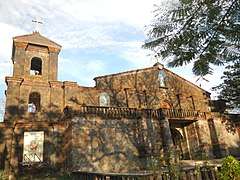
The name Moron was given during the 16th century. A group of Spaniards arrived and inquired from the natives the name of their place. The natives thought that the Spaniards were asking about the Moros who retreated after a severe fighting, so they replied, Mga Moro umuurong hence the place was called Moron. Moros was a reference to the first inhabitants who bartered their products in the 16th century. In 1578, it became part of Corrigimento de Mariveles together with Bagac and Maragondon, Cavite. But it was only in 1607 that Moron was officially founded as an ecclesiastical parish and as a pueblo including the Coral Stone Church by the Recollects and was officially founded by Fr. Rodrigo de San Miguel who placed it under the protection of the Our Lady of the Pillar. The Our Lady of the Pillar Parish of Morong, erected in 1607 (one of the oldest seats of Catholic faith in the Philippines) originally orchestrated from the elements of the Gothic, Renaissance, and Baroque sources. It culminated its 400th Year foundation anniversary on October 12, 2007.[5]
World War II
Conscription of Morong Residents
During the onset of the war, able-bodied men from Morong, Bataan were called to volunteer for the army. Many residents answered the call to serve. Later after the fall of Bataan up until the Liberation, boonie guerilla groups sought to fight and sabotage the Japanese occupying forces.
The Seven Day Battle of Mauban (Morong, Bataan)
For the defense of Bataan, the main and first battle position established by the USAFFE was the Mabatang(Abucay)-Mauban(Morong) Line. General Wainwright was in command of the Mauban side of the defense.
On 16 January 1942, Imperial Japanese Army and an Allied coalition of Filipino-American forces both raced to capture Morong. They reached the town around the same time, but the Allies had detected the Japanese first. Taking the opportunity for a surprise attack, Lieutenant Edwin P. Ramsey of the 26th Cavalry Regiment ordered his troops to charge; the 27 heavily outnumbered Filipino and American cavalrymen charged and scattered the surprised Japanese. It was the last charge of American cavalry.[6]
On January 18, 1942 that Japanese troops under General Kimura captured Poblacion, Morong. The entire town center was burned by the invading army leaving intact only a few houses which they utilized as garrisons. He had a force of 5,000 well equipped soldiers.
On the 21st, Lt. Col. Hiroshi Nakanishi, was able to establish a Japanese roadblock in Mauban in the vicinity of Kilometer Post (KP) 167 controlling the only major road suitable for transporting heavy equipment and supplies. Col. John H. Rodman, the regimental commander of the 92d Infantry, attempted to take down the Japanese roadblock but have failed. The 3d Infantry and elements of the 1st Infantry, under Col. Kearie Lee Berry also attacked the Japanese position but have also failed.
The deft and daring military tactics of Lt. Col. Nakanishi caused the withdrawal of American and Filipino troops from the Mauban Defense Line to Bagac in January 25, 1942.
Geography
Morong is located at 14°41′N 120°16′E / 14.68°N 120.27°E.
According to the Philippine Statistics Authority, the municipality has a land area of 219.20 square kilometres (84.63 sq mi) [2] constituting 15.97% of the 1,372.98-square-kilometre- (530.11 sq mi) total area of Bataan.
Barangays
Morong is politically subdivided into 5 barangays.[7]
| PSGC | Barangay | Population | ±% p.a. | |||
|---|---|---|---|---|---|---|
| 2015[3] | 2010[8] | |||||
| 030808001 | Binaritan | 20.0% | 5,966 | 5,273 | 2.38% | |
| 030808002 | Mabayo | 16.0% | 4,771 | 4,275 | 2.11% | |
| 030808003 | Nagbalayong | 20.8% | 6,207 | 5,680 | 1.70% | |
| 030808004 | Poblacion | 18.4% | 5,511 | 5,105 | 1.47% | |
| 030808005 | Sabang | 24.9% | 7,446 | 5,838 | 4.74% | |
| Total | 29,901 | 26,171 | 2.57% | |||
Demographics
| Population census of Morong | ||
|---|---|---|
| Year | Pop. | ±% p.a. |
| 1903 | 1,906 | — |
| 1918 | 2,576 | +2.03% |
| 1939 | 3,301 | +1.19% |
| 1948 | 3,336 | +0.12% |
| 1960 | 5,734 | +4.62% |
| 1970 | 6,738 | +1.62% |
| 1975 | 7,793 | +2.96% |
| 1980 | 10,637 | +6.42% |
| 1990 | 17,155 | +4.90% |
| 1995 | 18,731 | +1.66% |
| 2000 | 21,273 | +2.77% |
| 2007 | 27,119 | +3.41% |
| 2010 | 26,171 | −1.29% |
| 2015 | 29,901 | +2.57% |
| Source: Philippine Statistics Authority[3][8][9][10] | ||
In the 2015 census, Morong had a population of 29,901.[3] The population density was 140 inhabitants per square kilometre (360/sq mi).
Gallery
 Municipal hall
 Public market
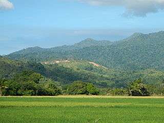 Morong landscape
 Seascape
 Park and covered court
References
- ↑ "Municipality". Quezon City, Philippines: Department of the Interior and Local Government. Retrieved 31 May 2013.
- 1 2 "Province: Bataan". PSGC Interactive. Quezon City, Philippines: Philippine Statistics Authority. Retrieved 12 November 2016.
- 1 2 3 4 5 Census of Population (2015). "Region III (Central Luzon)". Total Population by Province, City, Municipality and Barangay. PSA. Retrieved 20 June 2016.
- ↑ "Republic Act No. 1249; An Act Changing the Name of the Municipality of Moron, Province of Bataan, to Morong". LawPH.com. Archived from the original on 3 May 2012. Retrieved 18 October 2018.
- ↑ "History of Morong, Bataan". visitmorong.com. Retrieved 10 December 2014.
- ↑ Steve Shaw (4 September 2008). "The Last U.S. Cavalry Charge". Parting Shot. Western Shooting Horse Magazine. Retrieved 22 October 2009.
- ↑ "Municipal: Morong, Bataan". PSGC Interactive. Quezon City, Philippines: Philippine Statistics Authority. Retrieved 8 January 2016.
- 1 2 Census of Population and Housing (2010). "Region III (Central Luzon)". Total Population by Province, City, Municipality and Barangay. NSO. Retrieved 29 June 2016.
- ↑ Censuses of Population (1903–2007). "Region III (Central Luzon)". Table 1. Population Enumerated in Various Censuses by Province/Highly Urbanized City: 1903 to 2007. NSO.
- ↑ "Province of Bataan". Municipality Population Data. Local Water Utilities Administration Research Division. Retrieved 17 December 2016.
External links
| Wikimedia Commons has media related to Morong, Bataan. |
Places adjacent to Morong, Bataan | |
|---|---|