Bacolor, Pampanga
| Bacolor | ||
|---|---|---|
| Municipality | ||
| Municipality of Bacolor | ||
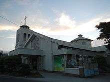
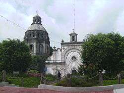 The half-buried San Guillermo Parish Church | ||
| ||
| Etymology: Level ground | ||
| Nickname(s): Athens of Pampanga | ||
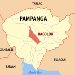 Map of Pampanga with Bacolor highlighted | ||
.svg.png) Bacolor Location within the Philippines | ||
| Coordinates: 15°00′N 120°39′E / 15°N 120.65°ECoordinates: 15°00′N 120°39′E / 15°N 120.65°E | ||
| Country |
| |
| Region | Central Luzon (Region III) | |
| Province | Pampanga | |
| District | 3rd District | |
| Founded | 1574 | |
| Barangays | 21 (see Barangays) | |
| Government [1] | ||
| • Type | Sangguniang Bayan | |
| • Mayor | Jose Maria O. Hizon | |
| • Electorate | 43,843 voters (2016) | |
| Area [2] | ||
| • Total | 71.70 km2 (27.68 sq mi) | |
| Population (2015 census)[3] | ||
| • Total | 39,460 | |
| • Density | 550/km2 (1,400/sq mi) | |
| Time zone | UTC+8 (PST) | |
| ZIP code | 2001 | |
| PSGC | 035404000 | |
| IDD : area code | +63 (0)45 | |
| Climate type | Tropical monsoon climate | |
| Income class | 3rd municipal income class | |
| Revenue (₱) | 137,654,961.27 (2016) | |
| Native languages |
Kapampangan Tagalog | |

Bacolor, officially the Municipality of Bacolor, (Kapampangan: Balen ning Bakúlud), is a 3rd class municipality in the province of Pampanga, Philippines. According to the 2015 census, it has a population of 39,460 people.[3]
History
Don Guillermo Manabat, a rich landlord, is believed to be the founder of Bacolor.[4] Historical records show that Bacolor has been in existence as a proposed settlement as early as 1571. When the Spaniards arrived they found Bakúlud; its original name meant "level ground" because the site was formerly part of the Luzon coastline until eruptions from ancestral Mount Pinatubo raised it above the ocean floor.
The first settlers of Bacolor were believed to be Malays that came from Atjeh in Sumatra led by Panday Pira. It is believed to have been founded by Monmon, first cousin and sister-in-law of Malangsic, a son of Prince Balagtas. However, historians recorded the official foundation of Bacolor to have occurred in 1574 through a landlord named Guillermo Manabat, whose palatial house and resting place is now the site of the San Guillermo Church, hence the church's name.
The name Bakúlud was changed to Bacólor when the Spaniards came to the place. It was recorded to have been the first capital of Pampanga for two centuries (1698 to 1904) before the provincial seat was transferred to San Fernando in July 1904. In 1757, the provincial building, Casa Real, was constructed at the place where the Bacolor Elementary School is now located.
During the British Occupation of the Philippines, when Manila fell to the British, it became capital of the exiled government of Governor General Simón de Anda y Salazar from October 6, 1762 to May 30, 1764. The provincial offices were temporarily moved to Factoría (now San Isidro, Nueva Ecija). It remained the former capital town of Pampanga until the provincial seat of government was transferred to neighboring San Fernando in 1904. Through a decree of the King of Spain on November 9, 1765, Bacolor became Villa de Bacólor, one of the only three villas in the Philippines and was granted a special coat of arms. Simón de Anda organized an army of natives for the defense of Bacolor and with the aim of recapturing Manila.
The coming of the American colonizers broke up the military form of government and instead political and economic reforms were introduced. A civil form of government was organized and was inaugurated on February 13, 1901 by Com. William H. Taft which took place in the old Escuela de Artes y Oficios de Bacólor, later known as the Pampanga School of Arts and Trade and now the Don Honorio Ventura Technological State University, the first state university in Pampanga.
The first provincial Civil Governor was Don Ceferino Joven and the first Municipal President of Bacolor was Don Estanislao Santos. Pampanga was acknowledged as the first province to have organized civil government in the Philippines by General Grant, the then President of the United States of America.
When the Second World War broke out, Japanese fighter and bomber planes invaded the municipal town in Bacolor on December 1941 until the town was occupied by the Imperial Japanese forces in 1942. Pampangan guerrillas and Hukbalahap Communist groups joined in an insurgency centered around the municipality of Bacolor, supported by local soldiers and military officers of the Philippine Commonwealth Army. Their attacks against the Japanese occupation continued until 1945, when Filipino and American forces liberated the municipality of Bacolor.
In 1956, the sitio of Mesalipit was converted into a barrio.[5]
On the morning of October 1, 1995, over 20 feet (6.1 m) of lahar from the slopes of Mount Pinatubo and surrounding mountains buried the entire barangay of Cabalantian among many others, killing hundreds of people. 18 out of the 21 barangays of Bacolor were buried. The lahar flows from the mountains raised the town to its current level of an approximate 37 meters above sea level. Subsidence caused the constant reclaiming of parts of Pampanga by the sea.
Barangays
Bacolor is politically subdivided into 21 barangays.
- Balas
- Cabalantian
- Cabambangan (Poblacion)
- Cabetican
- Calibutbut
- Concepcion
- Dolores
- Duat
- Macabacle
- Magliman
- Maliwalu
- Mesalipit
- Parulog
- Potrero
- San Antonio
- San Isidro
- San Vicente
- Santa Barbara
- Santa Ines
- Talba
- Tinajero
Demographics
| Population census of Bacolor | |||||||||||||||||||||||||||||||||||||||||||||||||
|---|---|---|---|---|---|---|---|---|---|---|---|---|---|---|---|---|---|---|---|---|---|---|---|---|---|---|---|---|---|---|---|---|---|---|---|---|---|---|---|---|---|---|---|---|---|---|---|---|---|
|
| ||||||||||||||||||||||||||||||||||||||||||||||||
| Source: Philippine Statistics Authority[3] [6] [7] [8] | |||||||||||||||||||||||||||||||||||||||||||||||||
In the 2015 census, the population of Bacolor, Pampanga, was 39,460 people,[3] with a density of 550 inhabitants per square kilometre or 1,400 inhabitants per square mile.
Local government
Like other towns in the Philippines, Bacolor is governed by a mayor and vice mayor who are elected to three-year terms. The mayor is the executive head and leads the town's departments in executing the ordinances and improving public services. The vice mayor heads a legislative council (Sangguniang Bayan) consisting of councilors from the barangays or barrios.
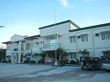
Town hall
The municipal building is the former site of the Venturas house, one of Bacolor's most prominent families. On July 8, 1953, the new town hall was completed during the tenure of Mayor Manuel de Jesus. Its construction was a project of Senator Pablo Angeles y David, a native of Bacolor.[9]
Tourism
A landmark in the town is the San Guillermo Parish Church known as the 'sunken church' and was one of the structures that was half-buried by the lava flow. The church has since been renovated and is currently operational and may be accessed through what were once the second floor windows, now converted into doorways. The sunken church and town of Bacolor were used to shoot the 2009 television series May Bukas Pa. The Shrine of Our Lady of Lourdes in Cabetican is also famous for its annual pilgrimage and barrio fiestas.
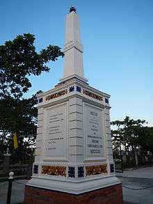
Other notable landmarks in Bacolor include Memorial Kilometer Posts of the Bataan Death March along the MacArthur Highway; the oldest trade school in Far East, the Don Honorio Ventura Technological State University; the Simón de Anda y Salazar monument at the town hall; monument to the Kapampangan writer and revolutionary leader Juan Crisostomo Soto (1867-1918); and Monument to Felix Galura Y Napao.[10]
Bacolor's festivals are the Feast of San Guillermo and Nuestra Senora del Santissimo Rosario (La Naval) which are celebrated every 10th day of February and 3rd Sunday of November, respectively.
The Sunken Shrine
Buried by the devastating lahar flows of Mount Pinatubo eruption in June 1991, the Archdiocesan Shrine of Our Lady of Lourdes of Cabetican (abbreviated as "Maluca") remains at the center of Marian Concordia Pilgrimages and Healing in Pampanga. Originally built as an annexe to the older, smaller shrine, it is under the care of Fr. Ronnie Cao, Healing Priest and Rector of the Archdiocesan Shrine.
References
- ↑ "Municipality". Quezon City, Philippines: Department of the Interior and Local Government. Retrieved 31 May 2013.
- ↑ "Province: Pampanga". PSGC Interactive. Quezon City, Philippines: Philippine Statistics Authority. Retrieved 12 November 2016.
- 1 2 3 4 Census of Population (2015). "Region III (Central Luzon)". Total Population by Province, City, Municipality and Barangay. PSA. Retrieved 20 June 2016.
- ↑ "Bacolor". Kapampangan Online. Archived from the original on May 3, 2013. Retrieved April 12, 2011.
- ↑ "An Act Creating the Barrio of Mesalipit in the Municipality of Bacolor, Province of Pampanga". LawPH.com. Archived from the original on 2012-07-19. Retrieved 2011-04-12.
- ↑ Census of Population and Housing (2010). "Region III (Central Luzon)". Total Population by Province, City, Municipality and Barangay. NSO. Retrieved 29 June 2016.
- ↑ Censuses of Population (1903–2007). "Region III (Central Luzon)". Table 1. Population Enumerated in Various Censuses by Province/Highly Urbanized City: 1903 to 2007. NSO.
- ↑ "Province of Pampanga". Municipality Population Data. Local Water Utilities Administration Research Division. Retrieved 17 December 2016.
- ↑ "Municipal building". Baculud.com. Archived from the original on 17 January 2013. Retrieved 12 December 2012.
- ↑ "Historical sites". Baculud.com. Archived from the original on 17 January 2013. Retrieved 12 December 2012.
External links
| Wikimedia Commons has media related to Bacolor, Pampanga. |
- Philippine Standard Geographic Code
- Philippine Census Information
- Local Governance Performance Management System
Places adjacent to Bacolor, Pampanga | |
|---|---|
San Fernando (capital) | |
| Municipalities | |
| Component cities | |
| Highly urbanized city |
|