Gainesville, Virginia
| Gainesville, Virginia | |
|---|---|
| Census-designated place (CDP) | |
 Houses in Gainesville | |
 Location in Prince William County and the state of Virginia. | |
| Coordinates: 38°47′41″N 77°37′14″W / 38.79472°N 77.62056°WCoordinates: 38°47′41″N 77°37′14″W / 38.79472°N 77.62056°W | |
| Country | United States |
| State | Virginia |
| County | Prince William |
| Area | |
| • Total | 10.3 sq mi (26.6 km2) |
| • Land | 9.7 sq mi (25.2 km2) |
| • Water | 0.6 sq mi (1.5 km2) |
| Elevation | 354 ft (108 m) |
| Population (2010) | |
| • Total | 11,481 |
| • Density | 1,150.2/sq mi (174.1/km2) |
| Time zone | UTC−5 (Eastern (EST)) |
| • Summer (DST) | UTC−4 (EDT) |
| ZIP codes | 20155-20156 |
| Area code(s) | 703, 571 |
| FIPS code | 51-30176[1] |
| GNIS feature ID | 1494951[2] |
Gainesville is a census-designated place (CDP) in western Prince William County, Virginia, United States. The population was 11,481 in the 2010 census.[3]
History
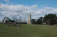
Gainesville was once a changing point for stagecoach horses on the Fauquier & Alexandria Turnpike. In 1752, Thomas Jefferson reached the area and the stop became Gainesville. It was a shipping point for grain, timber, and cattle and remained a major cattle shipping point into the early 1960s. During the American Civil War, nearby Thoroughfare Gap in the Bull Run Mountains served as a path for soldiers to reach the First and Second battles of Bull Run. In 1994, the groundbreaking for Gainesville's first townhome community began; it was named Crossroads. This marked the beginning of mass-development for Gainesville.
In 2006, the VDOT began working on the Gainesville Interchange improvement project, with construction officially starting in July 2011, in order to ease the traffic in the rapidly growing Gainesville-Haymarket area. It was completed on July 9, 2015.

Geography
Gainesville is located at 38°47′41″N 77°37′14″W / 38.79472°N 77.62056°W (38.794784, −77.620651).[4]
According to the United States Census Bureau, the CDP has a total area of 10.3 square miles (26.6 km²), of which 9.7 square miles (25.2 km²) is land and 0.6 square mile (1.5 km²) (5.45%) is water.
Climate
Gainesville has a humid subtropical climate (Köppen climate classification Cfa), with mild winters with brief cold snaps, and hot and humid summers with frequent thunderstorms. Spring and autumn are pleasantly warm. January is the coldest month with highs around 45 °F and lows around 25 °F. July is the warmest month, with highs around 90 °F and lows around 65 °F.
| Climate data for Gainesville, Virginia | |||||||||||||
|---|---|---|---|---|---|---|---|---|---|---|---|---|---|
| Month | Jan | Feb | Mar | Apr | May | Jun | Jul | Aug | Sep | Oct | Nov | Dec | Year |
| Average high °F (°C) | 44.1 (6.7) |
50.5 (10.3) |
58.0 (14.4) |
68.7 (20.4) |
75.3 (24.1) |
86.2 (30.1) |
90.0 (32.2) |
87.8 (31) |
83.3 (28.5) |
72.4 (22.4) |
58.6 (14.8) |
49.1 (9.5) |
68.7 (20.4) |
| Average low °F (°C) | 25.6 (−3.6) |
29.1 (−1.6) |
36.6 (2.6) |
42.4 (5.8) |
52.3 (11.3) |
60.8 (16) |
67.1 (19.5) |
64.8 (18.2) |
58.7 (14.8) |
46.3 (7.9) |
36.2 (2.3) |
28.3 (−2.1) |
45.7 (7.6) |
| Average precipitation inches (mm) | 2.6 (66) |
2.5 (64) |
2.8 (71) |
2.9 (74) |
3.7 (94) |
3.2 (81) |
3.1 (79) |
3.2 (81) |
3.3 (84) |
3.1 (79) |
3.1 (79) |
2.7 (69) |
36.2 (919) |
| Source: Weatherbase[5] | |||||||||||||
Demographics
Gainesville is currently the third-largest CDP in Prince William County. At the 2010 census,[2] there were 11,481 people, 3,959 households and roughly 3,100 families residing in the CDP. The population density was 1,150.2 per square mile (174.1/km²). There were 10,300 housing units at an average density of 189.6/sq mi (73.2/km²).
At the 2000 census, there were 4,382 people, 1,719 households, and 1,304 families residing in the CDPhe racial makeup of the CDP was 88.77% White, 6.80% African American, 0.23% Native American, 1.37% Asian, 0.05% Pacific Islander, 1.53% from other races, and 1.26% from two or more races. Hispanic or Latino of any race were 3.77% of the population.
There were 10,300 households of which 32.8% had children under the age of 18 living with them, 67.2% were married couples living together, 5.6% had a female householder with no husband present, and 24.1% were non-families. 18.6% of all households were made up of individuals and 3.8% had someone living alone who was 65 years of age or older. The average household size was 2.55 and the average family size was 2.91.
24.4% of the population were under the age of 18, 5.2% from 18 to 24, 36.7% from 25 to 44, 23.6% from 45 to 64, and 9.9% who were 65 years of age or older. The median age was 36 years. For every 100 females, there were 97.4 males. For every 100 females age 18 and over, there were 94.8 males.
The median household income was $76,300 and the median family income was $82,627. Males had a median income of $46,934 and females $40,385. The per capita income was $35,196. About 1.9% of families and 2.8% of the population were below the poverty line, including 3.7% of those under age 18 and 0.6% of those age 65 or over.
Danica Roem represents Gainesville in the Virginia House of Delegates.
Development
Major commercial and residential development has taken place since 2000, resulting in Gainesville having six large shopping centers. The intersection of I-66 and Lee Highway (29 Highway) has the largest shopping center with big box stores, such as Target Supercenter, Lowe's, Best Buy, DSW, Walgreens, and many other stores and restaurants. Somerset Crossing has a Bank Of America, Wells Fargo, and other shops. Close to US-15 are a Staples, Ross, Wegmans Food Markets, Michael's, and Harris Teeter. The Promenade at Virginia Gateway was developed by The Peterson Companies, including BJ's Warehouse, which opened in January 2012, and Regal Theaters which opened in late 2013.
A proposed Haymarket / Gainesville railway station extension for the VRE was scheduled to open in 2022, connecting the region via commuter rail to Fairfax County, Manassas, and Washington, D.C. However the project was voted down by the VRE Operations Board, in favor of expanding services to the existing station in Broad Run.[6]
References
- ↑ "American FactFinder". United States Census Bureau. Archived from the original on 2013-09-11. Retrieved 2008-01-31.
- 1 2 "US Board on Geographic Names". United States Geological Survey. 2007-10-25. Retrieved 2008-01-31.
- ↑ "2010 Census for Gainesville, Virginia, United States of America". Retrieved 21 December 2015.
- ↑ "US Gazetteer files: 2010, 2000, and 1990". United States Census Bureau. 2011-02-12. Retrieved 2011-04-23.
- ↑ "Weatherbase: Historical Weather for Gainesville, Virginia, United States of America". Retrieved 2009-06-20.
- ↑ "Plans for VRE expansion to Haymarket crumble". The Washington Post. 17 March 2017. Retrieved 20 March 2017.
External links
| Wikimedia Commons has media related to Gainesville, Virginia. |
| Administration |
|  | |||
|---|---|---|---|---|---|
| Organizations | |||||
| Landmarks | |||||
| Transportation | |||||
| Culture |
| ||||
| Education | |||||
Municipalities and communities of Prince William County, Virginia, United States | ||
|---|---|---|
| Towns | 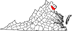 | |
| CDPs | ||
| Unincorporated communities | ||
| Footnotes | ‡This populated place also has portions in an adjacent county or counties | |