National Register of Historic Places listings in Manassas, Virginia
Location of Manassas in Virginia
This is a list of the National Register of Historic Places listings in Manassas, Virginia.
This is intended to be a complete list of the properties and districts on the National Register of Historic Places in the independent city of Manassas, Virginia, United States. The locations of National Register properties and districts for which the latitude and longitude coordinates are included below, may be seen in a Google map.[1]
There are 6 properties and districts listed on the National Register in the city.
- This National Park Service list is complete through NPS recent listings posted October 11, 2018.[2]
Current listings
| [3] | Name on the Register[4] | Image | Date listed[5] | Location | Description |
|---|---|---|---|---|---|
| 1 | Cannon Branch Fort | 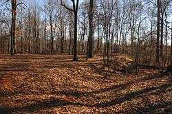 |
August 26, 1999 (#99001004) |
10611 Gateway Boulevard[6] 38°44′10″N 77°31′00″W / 38.736076°N 77.516788°W |
|
| 2 | Liberia | 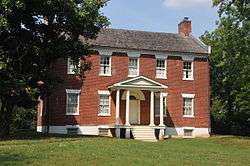 |
March 20, 1980 (#80004215) |
8601 Portner Ave.[7] 38°46′01″N 77°27′38″W / 38.766944°N 77.460556°W |
|
| 3 | Manassas Water Tower | 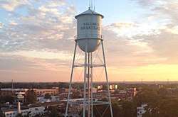 |
August 15, 2016 (#16000533) |
9000 Quarry St. 38°45′10″N 77°28′10″W / 38.752778°N 77.469444°W |
|
| 4 | Mayfield Fortification (44PW226) | 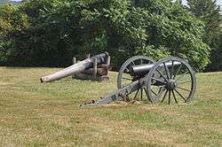 |
August 8, 1989 (#89001063) |
8401 Quarry Rd. 38°45′14″N 77°27′09″W / 38.753889°N 77.452500°W |
|
| 5 | Manassas Historic District | 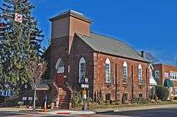 |
June 29, 1988 (#88000747) |
Roughly bounded by Quarry Rd., Prescott and Fairview Aves., the former Southern railroad line, and Grant Ave. 38°45′06″N 77°28′19″W / 38.751667°N 77.471944°W |
|
| 6 | Manassas Industrial School for Colored Youth | 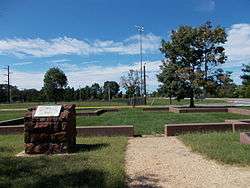 |
August 1, 1994 (#94000760) |
9601 Wellington Rd.[8] 38°44′47″N 77°29′16″W / 38.746389°N 77.487778°W |
See also
| Wikimedia Commons has media related to National Register of Historic Places in Manassas, Virginia. |
References
- ↑ The latitude and longitude information provided in this table was derived originally from the National Register Information System, which has been found to be fairly accurate for about 99% of listings. For about 1% of NRIS original coordinates, experience has shown that one or both coordinates are typos or otherwise extremely far off; some corrections may have been made. A more subtle problem causes many locations to be off by up to 150 yards, depending on location in the country: most NRIS coordinates were derived from tracing out latitude and longitudes from USGS topographical quadrant maps created under the North American Datum of 1927, which differs from the current, highly accurate WGS84 GPS system used by most on-line maps. Chicago is about right, but NRIS longitudes in Washington are higher by about 4.5 seconds, and are lower by about 2.0 seconds in Maine. Latitudes differ by about 1.0 second in Florida. Some locations in this table may have been corrected to current GPS standards.
- ↑ "National Register of Historic Places: Weekly List Actions". National Park Service, United States Department of the Interior. Retrieved on October 11, 2018.
- ↑ Numbers represent an ordering by significant words. Various colorings, defined here, differentiate National Historic Landmarks and historic districts from other NRHP buildings, structures, sites or objects.
- ↑ National Park Service (2008-04-24). "National Register Information System". National Register of Historic Places. National Park Service.
- ↑ The eight-digit number below each date is the number assigned to each location in the National Register Information System database, which can be viewed by clicking the number.
- ↑ "Cannon Branch Fort". City of Manassas. Retrieved 2012-02-20.
- ↑ "Liberia Plantation". Virginia is for Lovers.
- ↑ "Manassas, VA - Official Site - Industrial School & Jennie Dean Memorial". manassascity.org.


This article is issued from
Wikipedia.
The text is licensed under Creative Commons - Attribution - Sharealike.
Additional terms may apply for the media files.