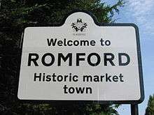
Romford
| Romford | |
|---|---|
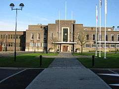 Havering Town Hall on Main Road | |
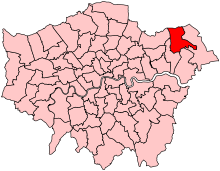
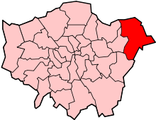
 Romford Romford shown within Greater London | |
| Population | 95,894 [1] |
| OS grid reference | TQ510887 |
| • Charing Cross | 14.1 mi (22.7 km) SW |
| London borough | |
| Ceremonial county | Greater London |
| Region | |
| Country | England |
| Sovereign state | United Kingdom |
| Post town | ROMFORD |
| Postcode district | RM1-RM7 |
| Dialling code | 01708 |
| Police | Metropolitan |
| Fire | London |
| Ambulance | London |
| EU Parliament | London |
| UK Parliament | |
| London Assembly | |
Romford is a large town in East London and the administrative centre of the London Borough of Havering. It is located 14.1 miles (22.7 km) northeast of Charing Cross and is one of the major metropolitan centres identified in the London Plan.[2] It was historically a market town within Essex[3] and formed the administrative centre of the liberty of Havering, until it was dissolved in 1892.[4] Good road links and the opening of the railway station in 1839 were key to the development of the town[3] and the economic history of Romford is underpinned by a shift from agriculture to light industry and then to retail and commerce.[3] As part of the suburban growth of London in the 20th century, Romford significantly expanded and increased in population,[5] becoming a municipal borough in 1937[6] and has formed part of Greater London since 1965.[7] It now forms one of the largest commercial, retail, entertainment and leisure districts outside central London[8] and has a developed night-time economy.[9]
History
| 1881 | 9,050 |
|---|---|
| 1891 | 10,722 |
| 1901 | 13,656 |
| 1911 | 16,970 |
| 1921 | 19,442 |
| 1931 | 35,918 |
| 1941 | war[N 1] |
| 1951 | 76,580 |
| 1961 | 114,584 |
| |
| source: UK census[5][10] | |
Toponymy
Romford is first recorded in 1177 as Romfort, which is formed from Old English 'rūm' and 'ford' and means "the wide or spacious ford".[11] The naming of the River Rom is a local 'back-formation' from the name of the town; and the river is elsewhere known as the Beam. The ford most likely existed on the main London to Colchester road where it crossed that river.[11]
The original site of the town was to the south, in an area still known as Oldchurch. It was moved northwards to the present site in the later medieval period to avoid the frequent flooding of the River Rom. The first building on the new site was the parish church of Saint Edward the Confessor.[12]
Economic development
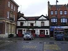
_p57a_-_Romford.jpg)
The original site of the town was to the south, in an area still known as Oldchurch. It was moved northwards to the present site in the later medieval period to avoid the frequent flooding of the River Rom. The first building on the new site was the parish church of Saint Edward the Confessor.[12] The town developed in the Middle Ages on the main road to London and the regionally significant Romford Market was established in 1247.[3] The early history of Romford and the immediate area is agricultural and it is recorded as being the location of a number of mills used to grind corn.[3] The area was a focus of the leather industry from the 15th to the early 19th centuries and there is record of a wide range of industries such as cloth making, weaving, charcoal burning, metal working and brewing.[3] Communications played an important part in its development; the main road to London was maintained by the Middlesex and Essex Turnpike Trust from 1721 and Romford became a coaching town in the 18th century.[13] Several failed attempts were made in the early 19th century to connect the town to the Thames via a Romford Canal. Initially intended to transport agricultural products to London and later intended to serve growing industrial sites in Romford, only two miles of canal were constructed and the canal company were unable to reach the town.[14]
The development of the town was accelerated by the opening of the railway station in 1839 which stimulated the local economy and was key to the development of the Star Brewery. Initially Eastern Counties Railway services operated between Mile End and Romford, with extensions to Brentwood and to Shoreditch in 1840. A second station was opened on South Street in 1892 by the London, Tilbury and Southend Railway on the line to Upminster and Grays, giving Romford a rail connection to Tilbury Docks. The two stations were combined into one in 1934.[13] Light industry slowly developed, reaching a peak in the 1970s with a number of factories on the edge of town, such as the Roneo Vickers office machinery company, Colvern manufacturers of wireless components, May's Sheet Metal Works and brush manufacturers Betterware.[3] Suburban expansion increased the population and reinforced Romford's position as a significant regional town centre. The Liberty Shopping Centre was constructed in the 1960s, and has been modernised and supplemented with further shopping centres throughout the town, including The Mall, opened in 1990 (as 'Liberty 2'); and The Brewery, opened in 2000 on the site of the old Star Brewery.[15]
Local government
Romford formed a chapelry in the large ancient parish of Hornchurch in the Becontree hundred of Essex; as well as the town it included the wards of Collier Row, Harold Wood, and Noak Hill.[16] Through ancient custom the area enjoyed special status and a charter in 1465 removed the parish from the Becontree hundred and the county of Essex and it instead formed the independent liberty of Havering.[4] Over time the vestry of Romford chapelry absorbed the local powers that would usually be held by the parish authorities[16] and in 1849 Romford became a separate parish within the liberty.[17] Improvement commissioners were set up in 1819 for paving, lighting, watching, and cleansing of the marketplace and main streets.[16] As the town grew this arrangement became ineffective at controlling sanitation and in 1851 a local board of health was set up for the parish; although its area was reduced in 1855 to cover only the town ward.[16] The remainder of the parish became part of the Romford rural sanitary district in 1875. These changes and the introduction of the Romford Poor Law Union in 1836[16] eroded the powers of the liberty and it was finally abolished in 1892 and reincorporated into Essex.[4]
The Local Government Act 1894 reformed local government and created the Romford Urban District and Romford Rural District to replace the local board and sanitary district; following which the Romford parish was split into Romford Urban and Romford Rural along the lines of the urban district.[16] In 1900 the parish was recombined and the urban district expanded to cover all of the former area of the historic chapelry, except for Noak Hill which remained in the rural district and had become a parish in its own right in 1895.[16] The enlarged urban district formed part of the London Traffic Area from 1924 and the London Passenger Transport Area from 1933.[18] The suburban expansion of London caused an increase in population during the 1930s[5] and the urban district was expanded further in 1934, taking in the parishes of Havering-atte-Bower and Noak Hill.[6] It was incorporated as the Municipal Borough of Romford in 1937.[6] In 1965 the municipal borough was abolished and its former area was combined with that of Hornchurch Urban District; it was again removed from Essex and since then has formed the northern part of the London Borough of Havering in Greater London.[19]
Suburban expansion
There was early expansion in the 1840s in the area now occupied by the Waterloo estate, and then known as New Romford, where 200 cottages were built.[13] To the east of the market place from 1850 middle class suburban housing was constructed with a much larger area of 200 acres (81 ha) built-over to the south of the railway from 1851. Through a gradual process of selling off former manors, houses were built radiating from the town in all directions for about a mile. More significant growth occurred between 1910 and 1911 with the construction of Gidea Park Garden Suburb, which included Raphael Park and Gidea Park railway station.[13] Large sections of land to the north of the town at Collier Row were developed in the interwar period and after World War II, the London County Council built the Harold Hill estate to the north east from 1948 to 1958.[13]
The right to supply electricity to the town was secured by the County of London Electricity Supply Company in 1913. Initially power was generated within the Star Brewery site, with the supply switching to Barking Power Station in 1925.[16] Gas supply began in 1825 with gas works of 25 acres (10 ha) constructed by 1938.[16] Following the Telegraph Act 1899 Romford became part of the Post Office London telephone area[20] and the Romford exchange was recorded as having 240 subscribers in 1916.[21] The town water supply initially came from the Havering Well, and 1859 a new public well and pump was built at the east end of the market.[16] The South Essex Waterworks Company started installing mains water supply in 1863 and had offices in South Street. By 1905 its supply was serving Ilford, Collier Row, Ardleigh Green, Brentwood, and Hornchurch. Sewage works were installed by the local board at Oldchurch in 1862, with further works built in Hornchurch in 1869.[16]
Governance
The Romford UK Parliament constituency consists of the Havering wards of Brooklands, Havering Park, Mawneys, Pettits, Romford Town, and Squirrel's Heath. In 2001 it had a population of 76,323.[22] The current MP is Andrew Rosindell, a native of the town. Romford forms part of the Havering and Redbridge London Assembly constituency and the London European Parliament constituency. Each ward elects three councillors to Havering London Borough Council. Following a boundary review of the constituency, it will also include the Hylands ward in the next election. The councillors elected in 2006 were: Brooklands – 3 Conservative;[23] Havering Park – 2 Conservative and 1 Collier Row and Mawneys Residents Association;[24] Mawneys – 3 Conservative;[25] Pettits – 3 Conservative;[26] Romford Town – 3 Conservative;[27] Squirrel's Heath – 3 Conservative after 2007 by-election;[28] and Hylands – 3 Conservative.[29]
Sports
Romford F.C., who currently play in the Isthmian League, is the local football team. The London Raiders ice hockey team is based in Romford. Romford is home to the Romford and Gidea Park Rugby Football Club, which was established in 1927. In 2003, the club became one of the first in the country to have a ladies Rugby team.
Geography

The town centre is about 50 feet (15 m) above sea level on a gravel terrace rising from the River Thames.[13] The north of the town has developed on London Clay and is situated as much as 150 feet (46 m) above sea level. The town centre is for the most part contained within a ring road formed of St Edwards Way, Mercury Gardens, Thurloe Gardens, Oldchurch Road and Waterloo Road. The market place and much of South Street and the High Street are pedestrianised.[8] The railway cuts through the town from east to west on a viaduct, with the bulk of the central Romford area to its north. The River Rom flows through the town in underground channels and joins the Thames after flowing through Hornchurch;[13] elsewhere along its course it is known as the River Beam[11] and forms part of the strategic waterways Blue Ribbon Network.[30] Romford has formed part of the continuously built-up area of London since the 1930s[31] and is contiguous with Rush Green to the west, Collier Row to the north, Gidea Park to the east and Hornchurch to the south east. The Romford post town covers all of the former municipal borough and extends over a much wider area, including parts of Barking and Dagenham and Epping Forest.[32] Climate data for Romford is taken from the nearest weather station at Greenwich, around 10 miles (16.1 km) south west of the marketplace:
| Climate data for London (LHR), elevation: 25 m or 82 ft, 1981–2010 normals, extremes 1948–present | |||||||||||||
|---|---|---|---|---|---|---|---|---|---|---|---|---|---|
| Month | Jan | Feb | Mar | Apr | May | Jun | Jul | Aug | Sep | Oct | Nov | Dec | Year |
| Record high °C (°F) | 17.2 (63) |
19.8 (67.6) |
24.2 (75.6) |
29.4 (84.9) |
32.8 (91) |
35.6 (96.1) |
36.7 (98.1) |
38.1 (100.6) |
35.4 (95.7) |
29.9 (85.8) |
20.8 (69.4) |
17.4 (63.3) |
38.1 (100.6) |
| Mean maximum °C (°F) | 13.1 (55.6) |
14.1 (57.4) |
17.2 (63) |
21.3 (70.3) |
25.8 (78.4) |
28.5 (83.3) |
30.1 (86.2) |
29.7 (85.5) |
25.5 (77.9) |
20.5 (68.9) |
16.2 (61.2) |
13.5 (56.3) |
31.5 (88.7) |
| Average high °C (°F) | 8.1 (46.6) |
8.4 (47.1) |
11.3 (52.3) |
14.2 (57.6) |
17.9 (64.2) |
21.0 (69.8) |
23.5 (74.3) |
23.2 (73.8) |
19.9 (67.8) |
15.5 (59.9) |
11.1 (52) |
8.3 (46.9) |
15.2 (59.4) |
| Daily mean °C (°F) | 5.2 (41.4) |
5.3 (41.5) |
7.6 (45.7) |
9.9 (49.8) |
13.3 (55.9) |
16.4 (61.5) |
18.7 (65.7) |
18.5 (65.3) |
15.7 (60.3) |
12.0 (53.6) |
8.0 (46.4) |
5.5 (41.9) |
11.3 (52.3) |
| Average low °C (°F) | 2.3 (36.1) |
2.1 (35.8) |
3.9 (39) |
5.5 (41.9) |
8.7 (47.7) |
11.7 (53.1) |
13.9 (57) |
13.7 (56.7) |
11.4 (52.5) |
8.4 (47.1) |
4.9 (40.8) |
2.7 (36.9) |
7.4 (45.4) |
| Mean minimum °C (°F) | −4.2 (24.4) |
−3.9 (25) |
−2.0 (28.4) |
−0.3 (31.5) |
3.1 (37.6) |
6.7 (44.1) |
9.5 (49.1) |
9.1 (48.4) |
6.0 (42.8) |
2.0 (35.6) |
−1.7 (28.9) |
−4.1 (24.6) |
−6.1 (21) |
| Record low °C (°F) | −13.2 (8.2) |
−9.6 (14.7) |
−5.1 (22.8) |
−2.6 (27.3) |
−0.9 (30.4) |
1.5 (34.7) |
5.6 (42.1) |
5.9 (42.6) |
1.8 (35.2) |
−3.3 (26.1) |
−7.0 (19.4) |
−11.8 (10.8) |
−13.2 (8.2) |
| Average precipitation mm (inches) | 55.2 (2.173) |
40.9 (1.61) |
41.6 (1.638) |
43.7 (1.72) |
49.4 (1.945) |
45.1 (1.776) |
44.5 (1.752) |
49.5 (1.949) |
49.1 (1.933) |
68.5 (2.697) |
59.0 (2.323) |
55.2 (2.173) |
601.7 (23.689) |
| Average precipitation days (≥ 1.0 mm) | 11.1 | 8.5 | 9.3 | 9.1 | 8.8 | 8.2 | 7.7 | 7.5 | 8.1 | 10.8 | 10.3 | 10.2 | 109.6 |
| Mean monthly sunshine hours | 61.5 | 77.9 | 114.6 | 168.7 | 198.5 | 204.3 | 212.0 | 204.7 | 149.3 | 116.5 | 72.6 | 52.0 | 1,632.6 |
| Source: Met Office [33] Royal Netherlands Meteorological Institute [34][35] | |||||||||||||
| Climate data for London Weather Centre, 2001–2014 normals | |||||||||||||
|---|---|---|---|---|---|---|---|---|---|---|---|---|---|
| Month | Jan | Feb | Mar | Apr | May | Jun | Jul | Aug | Sep | Oct | Nov | Dec | Year |
| Average high °C (°F) | 8.5 (47.3) |
8.9 (48) |
11.7 (53.1) |
15.7 (60.3) |
18.6 (65.5) |
22.4 (72.3) |
23.6 (74.5) |
23.2 (73.8) |
20.8 (69.4) |
16.1 (61) |
11.9 (53.4) |
8.6 (47.5) |
15.8 (60.5) |
| Daily mean °C (°F) | 6.8 (44.2) |
6.8 (44.2) |
8.8 (47.8) |
12.0 (53.6) |
14.8 (58.6) |
18.3 (64.9) |
19.6 (67.3) |
19.4 (66.9) |
17.3 (63.1) |
13.5 (56.3) |
10.0 (50) |
7.0 (44.6) |
12.9 (55.1) |
| Average low °C (°F) | 5.0 (41) |
4.7 (40.5) |
5.8 (42.4) |
8.2 (46.8) |
10.9 (51.6) |
14.1 (57.4) |
15.5 (59.9) |
15.5 (59.9) |
13.7 (56.7) |
10.9 (51.6) |
8.0 (46.4) |
5.4 (41.7) |
9.8 (49.7) |
| Source #1: Weather Online [36] | |||||||||||||
| Source #2: Tutiempo [37] | |||||||||||||
Demography
| Romford compared (2001 Census) | |||||
|---|---|---|---|---|---|
| Statistic | Romford Town[38] | Brooklands[39] | Havering[38] | London[38] | England[38] |
| Ethnic group | |||||
| White | 12,247 | 11,987 | 213,421 | 5,103,203 | 44,679,361 |
| Asian | 388 | 374 | 4,088 | 866,693 | 2,248,289 |
| Black | 234 | 389 | 3,139 | 782,849 | 1,132,508 |
| Mixed | 200 | 161 | 2,298 | 226,111 | 643,373 |
| Chinese/Other | 131 | 113 | 1,302 | 193,235 | 435,300 |
| Population | |||||
| Total | 13,200 | 13,024 | 224,248 | 7,172,091 | 49,138,831 |
| Density(/hectare) | 46.05 | 31.00 | 19.97 | 45.62 | 3.77 |
| Households | 5,829 | 5,361 | 91,722 | 3,015,997 | 20,451,427 |
The Havering committee area for Romford is defined as the wards of Romford Town and Brooklands.[40] Demographic data is produced by the Office for National Statistics for these wards. In 2001 the population of Romford Town was 13,200[38] and Brooklands was 13,024,[39] giving a total population of 26,224. In contrast, the approximate population of the area within the 2005 Romford Urban Strategy was estimated to be 36,500.[8] 71.52% in Romford Town and 70.48% in Brooklands report their religion as Christian, compared to 76.13% for Havering, 58.23% in London and 71.74% in England. 15.71% in Romford Town and 16.62% in Brooklands report having no religion, compared to 13.18% in Havering, 15.76% in London and 14.59% in England.[38][39]
In 2011, Romford was 82% White British, 5.8% Asian, 5% Other White and 4.7% Black.[41] The area is also predominantly Christian with 64% of the residents being part of the religion.
Economy
Romford is recognised in the London Plan as one of 13 regionally significant metropolitan centres in Greater London, with a considerable catchment area.[8] The total commercial floorspace in the town was 353,258 square metres (3,802,440 sq ft) in 2002, of which 147,627 square metres (1,589,040 sq ft) was retail space and 63,357 square metres (681,970 sq ft) was offices. The retail space is growing and in 2005 consisted of 190,000 square metres (2,000,000 sq ft).[15] The retail economy is complemented by a central business district close to the railway station, where the offices of employers such as Aon are located. Employment in the town centre was categorised in 2002 as approximately 40% commercial office, 40% comparison retail, 10% hospitality, 5% public sector, 2.5% service retail and 2.5% arts and entertainment.[8] Compared to the similar east London areas of Ilford, Stratford and Barking, there is more comparison retail and commercial office employment in Romford and less public sector work.[8] The total turnover of £413,395,000 in 2002 for Romford was larger than any other comparable town centre in east London and approximately 70% came from the commercial office businesses.[8] There is a developed night time economy, greater than in any other metropolitan centre in Greater London, with 8,360 square metres (90,000 sq ft) of cinemas, theatres and concert hall space; 9,530 square metres (102,600 sq ft) of bars and pubs; 5,510 square metres (59,300 sq ft) of cafés and restaurants; and 2,680 square metres (28,800 sq ft) of fast food and take away venues.[9] The night time economy is almost as significant as the day economy with around 12,000 visits to Romford during the day and 11,000 visits to pubs, clubs and bars at night.[8]
Transport
Roads
Romford's road centre is a dual-carriageway ring-road with three designations:
- North from The Brewery roundabout along St Edwards Way to The Mercury Mall it is the A118
- South from The Brewery roundabout to Oldchurch Roundabout it is the A125
- East from Oldchurch Roundabout to The Mercury Mall it is the A1251
Radiating from the Ring Road:
- The A118 runs east to west from Stratford in East London to the Gallows Corner. At the Gallows Corner, the road intersects with the A127 road to Southend[42] and the A12 trunk road between London and East Anglia.
- The A125 runs north to south, from the A12 trunk road traffic lights with the B175, to the A1306 near Rainham. At Rush Green the road intersects with the A124 which runs from Canning Town to Upminster.
Inside the Ring Road, the area is now heavily pedestrianized, with key roads no longer thoroughfares.
- South Street was originally the A125 main road connecting the A12 trunk road and the A13 trunk road
- High Street and Market Place was originally the A12 trunk road between London and East Anglia.
The east to west road was originally the A12, with the existing A12 trunk road being the old A106 from Wanstead to Gallows Corner [43]
Buses
There are several bus routes:
Coaches
National Express operate a daily 481 service from London to Ipswich via Colchester, and a daily 484 service from London to Walton-on-the-Naze via Colchester and Clacton.
Railway
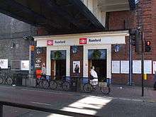
The town is served by Romford railway station in London fare zone 6.[44] Trains calling at the station are formed of the high-frequency Liverpool Street - Shenfield local TfL Rail service.[45] Some Greater Anglia services to/from Southend Victoria and Colchester Town also call at the station. A branch line shuttle on the Romford to Upminster Line connects Romford to Upminster, operated by London Overground.[45]
It is planned that the Liverpool Street-Shenfield service will be replaced by Crossrail in 2018[46] and there is a proposal that Romford will be served by a future extension of the East London Transit with changes to routes 5 (Canning Town - Romford Market), 368 (Barking Harts Lane - Chadwell Heath) and EL2 (Dagenham Dock - Becontree Heath).[47]
Air
Romford had an airport for passenger flights in the early 1930s located at Maylands Aerodrome. This is now the site of Maylands Golf Club on the A12.
Regular services to Clacton were operated by E.H. Hillman using Puss Moth and Fox Moth aircraft and The Midland & Scottish Air Ferries operated regular flights from Romford to Glasgow. There were expansion plans for E.H. Hillman to expand services to Paris, Glasgow and Belfast, but operations moved from Romford to Stapleford Aerodrome in the mid 1930s.[48] A conflict of interest between The Midland & Scottish Air Ferries and Scottish Motor Traction saw services cease in the mid 1930s.[49]
Religion
There are several churches in Romford. Confusingly, two of them are dedicated to Edward the Confessor, one of England's two kings that were made saints, and who lived at Havering-atte-Bower nearby. The main church, which is Anglican, is Romford's original church and situated in Market Place, in the heart of the town. The other one, which is Roman Catholic, is located to the north of the town centre, in Park End Road.
Other churches in the town centre include Trinity Methodist Church, in Angel Way; Salem Baptist Chapel in London Road; and another Anglican church, Saint Andrew's, in Saint Andrew's Road. All are located to the west.
Romford also has a synagogue, in Eastern Road, consecrated on 25 May 1956.[50]
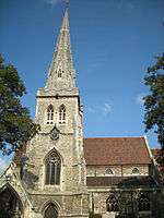
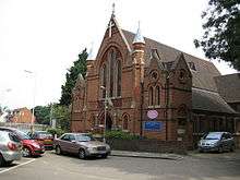
Saint Edward the Confessor's Church (Church of England)
The current church building, with its prominent spire, dates from 1850, and was designed by John Johnson. It is located on Market Place and replaced an earlier church of 1410. It has several monuments to the Hervey and Cooke families.
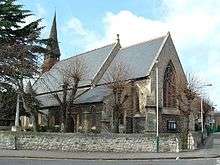
Saint Edward the Confessor's Church (Roman Catholic)
This church replaced a temporary building which stood on the site from 1854, and was built with money and on land donated by William Petre, 12th Baron Petre, who was from a prominent Catholic family; he was also responsible for other churches in Essex at Barking, Ongar, Brentwood and Chelmsford. Of relatively modest size and in a then rural location, St Edward’s was amongst the first 19th century churches built in Essex under the Catholic Diocese of Westminster, established in 1850. The church was dedicated in May 1856 by Nicholas Wiseman, the first Archbishop of Westminster, and designed by the London-based architect Daniel Cubitt Nichols.[51]
In 1917, a gallery was added to the west end of the chancel, and in 1934 the North Chapel was added.
The Church is built in the 13th century English Gothic style in coursed ragstone with a red-tiled roof and a central wooden belfry, topped by a splayed-foot spire and small dormers at the west end. The plan is of an aisle-less nave with a lower chancel, north chapel and south porch with a stair tower for the gallery (all at the west end of the church), with a sacristy linking it to the presbytery in the north-east corner. The windows are of Bath stone.[51]
Saint Andrew's Church
Saint Andrew's Church was built to cope with the growing population of Romford in the nineteenth and twentieth centuries. It was built in 1861-2 by John Johnson, the same architect who designed the present Saint Edward the Confessor's Church.[52]
Trinity Methodist Church
The red brick Trinity Methodist Church was completed in 1888. It has survived many troubles, including flooding in its opening year, damage on the night of 8/9 December 1940 by enemy action, and an arson attack on Christmas Eve 1980, when the church was only just saved from complete destruction by the presence of a police officer in a patrol car nearby, who managed to call the fire brigade.[53]
Salem Baptist Chapel
Salem Chapel stands on land which had been part of the old Napoleonic Barrack Ground. Hence the name for the nearby Waterloo Road. The land was auctioned in 1839, and in the following year the purchaser, a Mr George Gould, himself a Baptist, sold two plots fronting the London Road for the erection of a Baptist Chapel. The land was purchased and fenced for the sum of £300 which was raised by way of a mortgage. The original meeting room, (now the Church Parlour) was built and opened in July 1840. The present chapel was completed and opened in 1847.[54]
Culture
Havering Council's urban strategy aims to make Romford a cultural destination, whilst recognising that Hornchurch forms the main cultural hub of the borough with a large theatre and arts spaces.[8] As a former market and coaching town, Romford is well served by public houses and two that are located in the market place are listed buildings.[55] The market and adjacent streets also form a conservation area.[8][56]
Mass entertainment facilities in the town include the Brookside Theatre, Romford Greyhound Stadium, one of the few remaining dog racing tracks in London;[57] 2 multi-screen cinemas;[8] and until April 2013 Romford Ice Arena, which was home to the local Romford Raiders ice hockey team.[58][59] The Dolphin Centre was a popular swimming and leisure facility located in the town from 1982 to 1995, but the site was redeveloped into the current Axis residential tower block and Asda superstore in the mid-2000s. There is also a Romford F.C. associated with the town.[60] Romford Bowls Club, the premier bowls club in Essex, is based in Lodge Farm Park. The town is strongly associated with the electronic music group Underworld.[61]
| “ | Ride the sainted rhythms on the midnight train to Romford | ” |
| — Dirty Epic on dubnobasswithmyheadman, Underworld (1994)[61] | ||
Romford's position as a focus for electronic music production was reinforced by the presence of the Strictly Underground and Suburban Base record labels, with Suburban Base developing from the Boogie Times record store.[62] According to a Billboard article in 1992, Romford-produced dance music formed part of a trend favouring suburban and provincial "bedroom" record labels over those in central London.[63]
In popular culture
In 2013, the film Death Walks was filmed in Romford over a four-month period.
The cult TV series Garth Marenghi's Darkplace was set in the fictional Darkplace Hospital, in Romford.
Local media
The local newspapers for the town and the borough of Havering are the Romford Recorder, Romford and Havering Post and Romford Yellow Advertiser. Two radio stations are located in the area: Time 107.5 [64] and Bedrock (hospital radio)[65]
See also
References
- ↑ http://ukpollingreport.co.uk/2015guide/romford/
- ↑ Mayor of London (February 2008). "London Plan (Consolidated with Alterations since 2004)" (PDF). Greater London Authority. Archived from the original (PDF) on 31 October 2012. Retrieved 6 August 2009.
- 1 2 3 4 5 6 7 Powell, W.R. (Edr.) (1978). Romford: Economic History, A History of the County of Essex: Volume 7. Victoria County History. British History Online. Retrieved 6 August 2009.
- 1 2 3 Powell, W.R. (Edr.) (1978). The liberty of Havering-atte-Bower, A History of the County of Essex: Volume 7. Victoria County History. British History Online. Retrieved 16 August 2009.
- 1 2 3 Great Britain Historical GIS / University of Portsmouth, Romford parish (created 1900) population. Retrieved 6 August 2009.
- 1 2 3 4 Great Britain Historical GIS / University of Portsmouth, Romford UD/MB (historic map). Retrieved 14 August 2009.
- ↑ Young, K. & Garside, P., (1982). Metropolitan London: Politics and Urban Change 1837-1981.
- 1 2 3 4 5 6 7 8 9 10 11 Urban Practitioners & Allies and Morrison (July 2005). "Romford Urban Strategy". Havering London Borough Council. Archived from the original on 8 June 2011. Retrieved 14 August 2009.
- 1 2 Mayor of London (June 2006). "Managing the Night Time Economy" (PDF). Greater London Authority. Archived from the original (PDF) on 4 June 2011. Retrieved 14 August 2009.
- ↑ Great Britain Historical GIS / University of Portsmouth, Romford parish (abolished 1894) population. Retrieved 6 August 2009.
- 1 2 3 Mills, A.D. (2001). Dictionary of London Place Names. Oxford.
- 1 2 Weinreb, Ben, and Hibbert, Christopher (1992). The London Encyclopaedia (reprint ed.). Macmillan. p. 675.
- 1 2 3 4 5 6 7 Powell, W.R. (Edr.) (1978). Romford: Introduction, A History of the County of Essex: Volume 7. Victoria County History. British History Online. Retrieved 6 August 2009.
- ↑ "Archaeological Investigations Project 2001: Greater London" (PDF). Bournemouth University. 2001. Retrieved 14 August 2009.
- 1 2 Havering London Borough Council. "Romford Town Centre". Archived from the original on 27 September 2007. Retrieved 6 August 2009.
- 1 2 3 4 5 6 7 8 9 10 11 Powell, W.R. (Edr.) (1978). Romford: Local government, A History of the County of Essex: Volume 7. Victoria County History. British History Online. Retrieved 6 August 2009.
- ↑ Great Britain Historical GIS / University of Portsmouth, Havering atte Bower liberty. Retrieved 6 August 2009.
- ↑ Robson, William (1939). The Government and Mis-government of London. London: Allen & Unwin.
- ↑ Great Britain Historical GIS / University of Portsmouth, Havering LB (historic map). Retrieved 6 August 2009.
- ↑ Crang, Crang & May (1999). Virtual Geographies. Routledge.
- ↑ "London Telephone Area in 1916". Private Line. Archived from the original on 14 December 2006. Retrieved 14 August 2008.
- ↑ "2001 Census, Census Area Statistics, Key Figures, Area: Romford (Westminster Parliamentary Constituency)". Office for National Statistics. 2001. Retrieved 14 August 2009.
- ↑ "Brooklands Ward". Havering London Borough Council. Archived from the original on 8 June 2011. Retrieved 14 August 2009.
- ↑ "Havering Park Ward". Havering London Borough Council. Archived from the original on 8 June 2011. Retrieved 14 August 2009.
- ↑ "Mawneys Ward". Havering London Borough Council. Archived from the original on 8 June 2011. Retrieved 14 August 2009.
- ↑ "Pettits Ward". Havering London Borough Council. Archived from the original on 8 June 2011. Retrieved 14 August 2009.
- ↑ "Romford Town Ward". Havering London Borough Council. Archived from the original on 8 June 2011. Retrieved 14 August 2009.
- ↑ "Squirrel's Heath Ward". Havering London Borough Council. Archived from the original on 8 June 2011. Retrieved 14 August 2009.
- ↑ "Hylands Ward". Havering London Borough Council. Archived from the original on 8 June 2011. Retrieved 14 August 2009.
- ↑ Mayor of London (2004). "The blue ribbon network". Greater London Authority. Archived from the original on 31 May 2010. Retrieved 14 August 2009.
- ↑ Robson, William (1939). The Government and Mis-government of London. London: Allen & Unwin. pp. 26–27.
- ↑ Royal Mail (2004). Address Management Guide. Royal Mail Group. p. 168.
- ↑ "London Heathrow Airport". Met Office. Retrieved 17 September 2014.
- ↑ "Heathrow Airport Extreme Values". KNMI. Retrieved 29 November 2015.
- ↑ "Heathrow 1981–2010 mean maximum and minimum values". KNMI. Retrieved 28 December 2017.
- ↑ "London Weather Centre analysis". Weather Online. Retrieved 17 November 2014.
- ↑ "climate: Climate London Weather Centre". Tutiempo. Retrieved 17 November 2014.
- 1 2 3 4 5 6 Neighbourhood Statistics (2001). "2001 Census: Census Area Statistics, Area: Romford Town (Ward)". Office for National Statistics. Retrieved 14 August 2008.
- 1 2 3 Neighbourhood Statistics (2001). "2001 Census: Census Area Statistics, Area: Brooklands (Ward)". Office for National Statistics. Retrieved 14 August 2008.
- ↑ Romford Area Committee (June 2009). "Romford Area Committee (Brooklands and Romford Town Wards) Agenda". Havering London Borough Council. Archived from the original on 8 June 2011. Retrieved 14 August 2008.
- ↑ http://ukpollingreport.co.uk/2015guide/romford/
- ↑ "Map of Havering". Havering London Borough Council. Archived from the original on 27 February 2007. Retrieved 16 August 2008.
- ↑ Sabre Maps 51.57607,0.17049
- ↑ Transport for London (March 2009). "High frequency services" (PDF). Greater London Authority. Retrieved 14 August 2008.
- 1 2 National Express East Anglia (May 2009). "Table 6" (PDF). National Express. Retrieved 13 August 2009.
- ↑ "Crossrail maps: Route map". Crossrail. Archived from the original on 15 June 2009. Retrieved 14 August 2009.
- ↑ Transport for London. "East London Transit". Greater London Authority. Retrieved 6 August 2009.
- ↑ http://www.airfieldinformationexchange.org/community/showthread.php?11490-Maylands-(Romford)
- ↑ Hutchison, Iain. "Trade and Communications: Airways". The Glasgow Story. Archived from the original on 4 March 2016.
- ↑ "Romford and District Synagogue". Jewish Historical Records. Retrieved 27 February 2015.
- 1 2 "St Edward's Roman Catholic Parish - A Brief History". St Edward's RC Church, Romford. Retrieved 26 February 2015.
- ↑ "Saint Andrew's Church Romford - Photographs and History". Essex Churches. Retrieved 27 February 2015.
- ↑ "History of Trinity". Trinity Church Romford. Retrieved 27 February 2015.
- ↑ "Salem Baptist Church - History". Salem Baptist Church. Retrieved 27 February 2015.
- ↑ "Listed buildings in Romford". Havering London Borough Council. Archived from the original on 8 June 2011. Retrieved 4 January 2010.
- ↑ Planning Department (2006). "Romford Conservation Area". Havering London Borough Council. Archived from the original on 8 June 2011. Retrieved 21 September 2009.
- ↑ BBC News (19 May 2008). "Walthamstow race track to close". BBC. Retrieved 16 August 2009.
- ↑ "Hockey is Back!". Romford Ice Arena. Archived from the original on 6 April 2008. Retrieved 14 August 2009.
- ↑ "Skaters left without a home as doors close on ice rink". Romford Recorder. Retrieved 31 March 2013.
- ↑ Romford Football Club. "History". Retrieved 14 August 2009.
- 1 2 Ben Thompson (25 August 2000). "On top of the Underworld". London: The Independent. Retrieved 14 August 2009.
- ↑ Shapiro, Peter (1999). Drum 'n' bass: the rough guide. Rough Guides.
- ↑ Sexton, Paul (August 1992). UK indies step outside london for dance hits. Billboard.
- ↑ "Time FM". Time 107.5.
- ↑ "Bedrock (Hospital Radio)". Bedrock (Hospital Radio).
Further reading
- James Thorne (1876), "Romford", Handbook to the Environs of London, London: John Murray
External links
| Wikimedia Commons has media related to Romford. |
- Havering London Borough Council: A history of Romford
- Romford Now & Then
- Romford photos, maps and memories

| Districts |
|  |
|---|---|---|
| Attractions | ||
| Major retail | ||
| Places of worship | ||
| Parks and open spaces | ||
| Constituencies | ||
| Tube and rail stations | ||
| Other topics | ||