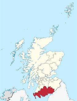
Dumfries and Galloway
| Dumfries and Galloway Dumfries an Gallowa Dùn Phris is Gall-Ghaidhealaibh | ||
|---|---|---|
 | ||
| ||
| Admin HQ | Dumfries | |
| Government | ||
| • Body | Dumfries and Galloway Council | |
| • Control | Ind + Lab (council NOC) | |
| • MPs |
| |
| • MSPs |
| |
| Area | ||
| • Total | 2,481 sq mi (6,427 km2) | |
| Area rank | Ranked 3rd | |
| Population (mid-2017 est.) | ||
| • Total | 149,200 | |
| • Rank | Ranked 13th | |
| • Density | 60/sq mi (23/km2) | |
| ONS code | S12000006 | |
| ISO 3166 code | GB-DGY | |
| Website | http://www.dumgal.gov.uk/ | |

Dumfries and Galloway (Scots: Dumfries an Gallowa; Scottish Gaelic: Dùn Phrìs is Gall-Ghaidhealaibh) is one of 32 unitary council areas of Scotland and is located in the western Southern Uplands. It comprises the historic counties of Dumfriesshire, Stewartry of Kirkcudbright and Wigtownshire, the latter two of which are collectively known as Galloway. The administrative centre is the town of Dumfries.
Following the 1975 reorganisation of local government in Scotland, the three counties were joined to form a single region of Dumfries and Galloway, with four districts within it. Since the Local Government etc. (Scotland) Act 1994, however, it has become a unitary local authority. For lieutenancy purposes, the historic counties are largely maintained with its three lieutenancy areas being Dumfries, Wigtown and the Stewartry of Kirkcudbright.
To the north, Dumfries and Galloway borders East Ayrshire, South Ayrshire and South Lanarkshire; in the east the Borders; and to the south the county of Cumbria in England and the Solway Firth. To the west lies the Irish Sea.
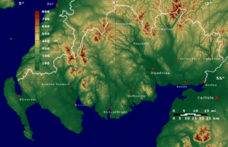
Geography
The Dumfries and Galloway Council region is composed of counties and their sub-areas. From east to west:
- Dumfriesshire County
- Kirkcudbrightshire County
- Wigtownshire County
- the sub-area of Wigtownshire – Machars (archaically, Farines)--divided into census areas (civil parish areas)
- the sub-area of Wigtownshire – Rhins of Galloway divided into census areas (civil parish areas)
The term 'Dumfries and Galloway' has been used since at latest the 19th century – by 1911 the three counties had a united Sheriffdom under that name. Dumfries and Galloway covers the majority of the Western area of the Southern Uplands,[1] it also hosts Scotland's most Southerly point, at the Mull of Galloway[2] in the west of the region.
Water systems and transport routes through the Southern Uplands
The region has a number of south running water systems which break through the Southern Uplands creating the main road, and rail, arteries north/south through the region and breaking the hills up into a number of ranges.
- River Cree valley carries the A714 north-westward from Newton Stewart to Girvan and Water of Minnoch valley which lies just west of the Galloway Hills carries a minor road northward through Glentrool village into South Ayrshire. This road leaves the A714 at Bargrennan.
- Water of Ken and River Dee form a corridor through the hills called the Glenkens[3] which carries the A713 road from Castle Douglas to Ayr. The Galloway Hills lie to the west of this route through the hills and the Carsphairn and Scaur Hills lie to the east.
- River Nith rises between Dalmellington and New Cumnock in Ayrshire and runs east then south down Nithsdale to Dumfries. Nithsdale carries both the A76 road and the rail line from Dumfries to Kilmarnock. It separates the Carsphairn and Scaur Hills from the Lowther Hills which lie east of the Nith.
- River Annan combines with Evan Water and the River Clyde to form one of the principal routes into central Scotland from England – through Annandale and Clydesdale – carrying the M74 and the west coast railway line. This gap through the hills separates the Lowthers from the Moffat Hills.
- River Esk enters the Solway Firth just south of Gretna having travelled south from Langholm and Eskdalemuir. The A7 travels up Eskdale as far as Langholm and from Langholm carries on up the valley of Ewes Water to Teviothead where it starts to follow the River Teviot to Hawick. Eskdale itself heads north west from Langholm through Bentpath and Eskdalemuir to Ettrick and Selkirk.
The A701 branches off the M74 at Beattock, goes through the town of Moffat, climbs to Annanhead above the Devil's Beef Tub (at the source of the River Annan) before passing the source of the River Tweed and carrying on to Edinburgh. Until fairly recent times the ancient route to Edinburgh travelled right up Annandale to the Beef Tub before climbing steeply to Annanhead.[4] The present road ascends northward on a ridge parallel to Annandale but to the west of it which makes for a much easier ascent.
From Moffat the A708 heads north east along the valley of Moffat Water (Moffatdale) on its way to Selkirk. Moffatdale separates the Moffat hills (to the north) from the Ettrick hills to the south.
National Scenic Areas
There are three National Scenic Areas within this region.
- Nith Estuary:[5] this area follows the River Nith southward from just south of Dumfries into the Solway Firth. Dumfries itself has a rich history going back over 800 years as a Royal Burgh (1186) and is particularly remembered as the place where Robert the Bruce murdered the Red Comyn in 1306 before being crowned King of Scotland – and where Robert Burns spent his last years. His mausoleum is in St Michael's graveyard. Going down the east bank there is the village of Glencaple, Caerlaverock Castle, Caerlaverock Wild Fowl Trust, an ancient Roman fort on Ward Law Hill[6] and nearby in Ruthwell is the Ruthwell Cross and the Brow Well[7] where Robert Burns "took the waters" and bathed in the Solway just before his death. On the west bank, there are several walks and cycle routes in Mabie Forest,[8] Kirkconnell Flow[9] for the naturalist, the National Museum of Costume[10] just outside New Abbey and Sweetheart Abbey within the village. Criffel (569 metres) offers the hill walker a reasonably modest walk with views across the Solway to the Lake District. The house of John Paul Jones founder of the American Navy is also open to visitors near Kirkbean.
- East Stewartry Coast:[11] this takes in the coast line from Balcary Point[12] eastward across Auchencairn Bay and the Rough Firth past Sandyhills to Mersehead.[13] There are several coastal villages within this area – Auchencairn, Kippford, Colvend, Rockcliffe, and Portling. There is also a round tower at Orchardton and the islands of Hestan Isle and Rough Island can be reached at low tide outside the breeding season for birds. Mersehead is a wildfowl reserve. The area has a number of coastal paths.
- Fleet Valley:[14] this area takes in Fleet Bay with its holiday destinations of Auchenlarie, Mossyard Bay, Cardoness, Sandgreen and Carrick Shore. The area also includes the town of Gatehouse of Fleet and the historic villages of Anworth and Girthon – there is a castle at Cardoness in the care of Historic Scotland.
Governance and Place-names
The region was created in 1975, by merging the counties of Wigtownshire, Kirkcudbrightshire and Dumfriesshire as a two-tier region with the districts of Wigtownshire, Stewartry, Nithsdale, and Annandale and Eskdale within it. After 1996 the unitary authority became known as Dumfries and Galloway Council still with Wigtownshire, Stewartry, Nithsdale, Annandale and Esdale within it.
County councils as administrative authorities were created in 1889. The present-day, "Dumfries and Galloway Council Area" exist for administrative purposes.
The historic counties of Britain, at least most of them, have existed for around 1,000 years or more and are often logical geographical entities in themselves. In Scotland they originated as Sheriffdoms consisting of a group of parishes over which the sheriff had jurisdiction,[15] replacing native "Celtic" forms of government with Norman feudal structures.
Transport
Transport in the region is operated by bus companies Houston's, McEwan's, Stagecoach Western and McCall's coaches, and train operators Abellio ScotRail, TransPennine Express, Virgin Trains and Northern.
Railway
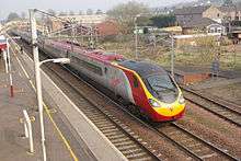
The region has seven working railway stations. All are on the Glasgow South Western Line, except Lockerbie which is on the West Coast Main Line.
Bus and coach
The area is served by buses which connect the main population centres. Express bus services link the main towns with Glasgow, Ayr, Edinburgh and Carlisle. Local bus services are also operated across the region.
Sea
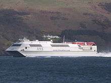
Dumfries and Galloway is home to two ports which have services to Northern Ireland, both are in the West of the region. Stena Line and P&O Irish Sea both have a port in the village of Cairnryan.
Air
The region also has no commercial airports; the nearest are Glasgow Prestwick Airport and Carlisle Lake District Airport. The region does host a number of private airfields. The town of Lockerbie was the scene of the Pan Am Flight 103 terrorist attack on 21 December 1988.
Roads
The main roads to and from the region are:
The Port Line
The mainline from Dumfries railway station via Newton Stewart to Stranraer Harbour railway station, was closed under the Beeching Axe. The line previously connected London Euston and the West Coast Main Line with the ferries to Larne Harbour railway station and the Port of Belfast.
The Port Road to Stranraer being the last to go in June 1965 leaving only the original G&SWR main line open to serve the Stranraer. The Beeching Axe cutting the Castle Douglas and Dumfries Railway and Portpatrick and Wigtownshire Railway has resulted in adverse mileage to connect Stranraer with a longer line via Kilmarnock and Ayr.
Emergency services
The Dumfries and Galloway Constabulary (Dissolved 2013 and now Police Scotland) is the police force for the region, and is the smallest in the United Kingdom. Dumfries and Galloway Fire and Rescue Service provide firefighting services across the region. The Coastguard, Lifeboats, Moffat mountain rescue and Galloway Mountain Rescue also offer emergency services across Dumfries and Galloway.
Nith Inshore Rescue is based at Glencaple. This an independent lifeboat providing water rescue cover for the River Nith, surrounding rivers and inland water. Nith Inshore Rescue is a declared facility for HM Coastguard who are the control centre and overseeing authority responsible for call outs.
NHS Dumfries and Galloway provide healthcare services across the region. The two main hospitals are the Dumfries and Galloway Royal Infirmary in Dumfries and Galloway Community Hospital in Stranraer.
Education
Dumfries & Galloway Council provides nursery, primary and secondary education across the region.
Alternative Schools
Nurseries and primary schools
For a list of nurseries and primary schools see this page.
Secondary schools

- Annan Academy
- Castle Douglas High School
- Dalbeattie High School
- Douglas Ewart High School, Newton Stewart
- Dalry Secondary School
- Dumfries Academy
- Dumfries High School
- Kirkcudbright Academy
- Langholm Academy
- Lockerbie Academy
- Maxwelltown High School, Dumfries
- Moffat Academy
- Sanquhar Academy
- St Joseph's College
- Stranraer Academy
- Wallace Hall Academy, Thornhill
Wildlife
The region is known as a stronghold for several rare and protected species of amphibian, such as the Natterjack toad and the Great crested newt.[16] There are also RSPB Nature Reserves at the Mull of Galloway,[17] Wood of Cree (Galloway Forest Park),[18] Ken Dee Marshes (near Loch Ken)[19] and Mereshead (near Dalbeattie on the Solway Firth)
Outdoor activities
There are five of the world class 7Stanes[20] mountain biking centres in Dumfries and Galloway at Dalbeattie, Mabie, Ae, Glentrool and Kirroughtree. The Sustrans Route 7[21] long distance cycle route also runs through the region. There is excellent hill walking in the Moffat Hills,[22] Lowther Hills [23] the Carsphairn and Scaur Hills [24] and Galloway Hills.[25] The Southern Upland Way[26] coast to coast walk passes through Dumfries and Galloway and the 53-mile long Annandale Way [27] travels from the Solway Firth into the Moffat hills near the Devil's Beef Tub. There is also fresh water sailing on Castle Loch at Lochmaben[28] and at various places on Loch Ken[29][30] Loch Ken also offers waterskiing and wakeboarding. [31] The Solway Firth coastline offers endless fishing, caravaning and camping, walking and sailing opportunities.
Arts and culture
Dumfries and Galloway is well known for its arts and cultural activities as well as its natural environment.
The major festivals including the region-wide Dumfries & Galloway Arts Festival and Spring Fling Open Studios. Other festivals include Big Burns Supper in Dumfries and the Wigtown Book Festival in Wigtown – Scotland's national book town.
Towns and villages
Main settlements in bold text.
- Ae, Airieland, Airds of Kells, Annan, Anwoth, Ardwell
- Beattock, Beeswing, Borgue, Brydekirk
- Caerlaverock, Cairngaan, Cairnryan, Cargenbridge, Carsphairn, Castle Douglas, Castle Kennedy, Clarencefield, Corsock, Creetown
- Dalbeattie, Dalton, Dornock, Drumlanrig, Drummore, Dumfries, Dundrennan, Dunscore
- Eastriggs, Ecclefechan, Eskdalemuir
- Garlieston, Gatehouse of Fleet, Glenluce, Gretna Green, Gretna
- Haugh of Urr, Hoddom
- Isle of Whithorn
- Johnsfield, Johnstonebridge
- Keir, Kelloholm, Kippford, Kirkbean, Kirkcolm, Kirkcudbright, Kirkconnel, Kirkinner, Kirkpatrick Durham
- Langholm, Leswalt, Locharbriggs, Lochmaben, Lockerbie
- Middleshaw, Millhousebridge, Mochrum, Moffat, Moniaive, Muirhead Mull of Galloway
- New Abbey, New Galloway, New Luce, Newton Stewart, Newton Wamphray
- Palnackie, Parton, Penpont, Portpatrick
- Parkgate
- Robgill Tower, Ringford
- Ruthwell,
- Sandhead, Sanquhar, Sorbie, St. John's Town of Dalry, Stoneykirk, Stranraer
- Terregles, Thornhill, Twynholm, Templand
- Unthank
- Wanlockhead, Whithorn, Wigtown
Places of interest
Moniaive the jewel in the crown of Dumfries & Galloway
- Caerlaverock Castle – Historic Scotland
- Caerlaverock NNR (national nature reserve)
- Cardoness Castle
- Cream o' Galloway
- Corsewall Lighthouse, privately owned
- HM Factory, Gretna, Eastriggs – site of a munitions factory[32] during the World War I
- Drumlanrig Castle
- Dunragit
- Galloway Forest Park, Forestry Commission
- Galloway Hydro Electric Scheme, Scottish Power
- Glenlair – home of 19th century physicist James Clerk Maxwell
- Glenluce Abbey
- Isle of Whithorn Castle
- Kenmure Castle – a seat of the Clan Gordon
- Loch Ken
- MacLellan's Castle, Kirkcudbright
- Mull of Galloway – RSPB/ South Rhins Community Development Trust
- Motte of Urr
- Ruthwell Cross
- Samye Ling Tibetan Monastery
- Southern Upland Way – long distance footpath
- Sweetheart Abbey, New Abbey
- Threave Castle
- WWT Caerlaverock – a reserve of the Wildfowl and Wetlands Trust
Council political composition
Before 2007, the council consisted of 47 councillors elected for a four-year term. 13 Council wards were introduced for the 2007 election with each ward returning three or four members for a five-year term by the single transferable vote system of election. This system was introduced by the Local Governance (Scotland) Act 2004,[33] as a means of ensuring a reasonably proportionately representative outcome.
2003–2007
The result of the 2003 election returned a council with no party having overall control.[34] A 'silver' coalition was first formed involving all parties but Conservative and Labour, after this coalition resigned[35] Labour took minority control of the council. The following number of councillors were elected for each party as follows:
| Party | Councillors | |
| Labour | 14 | |
| Independent | 12 | |
| Conservative | 11 | |
| Scottish National Party | 5 | |
| Liberal Democrat | 5 |
2007–2011
The result of the 2007 election returned the following number of councillors for each party as follows:
| Party | Councillors | |
| Conservative | 18 | |
| Labour | 14 | |
| Scottish National Party | 10 | |
| Liberal Democrat | 3 | |
| Independent | 2 |
After the resignation of Bruce Hodgson (Conservative councillor for the Abbey ward) a by-election was held on 1 May 2008, with Michael Thomson (Conservative) being returned as the replacement councillor.[36] On Tuesday 20 May 2008, Councillor Robert Higgins stood down as Scottish National Party (SNP) Group Leader, after he received a triple driving ban for reckless driving.[37] Similarly Councillor John Charteris Conservative was banned from driving for 12 months and fined £500 after he admitted to drunk driving at Dumfries Sheriff Court on Friday, 29 August 2008[38]
2012–2017
| Party | Councillors | |
| Labour | 15 | |
| Conservative | 14 | |
| Scottish National Party | 10 | |
| Liberal Democrat | 1 | |
| Independent | 7 |
The council was controlled by a Conservative and Scottish National Party (SNP) coalition until late 2013, when the resignation of seven Conservative councillors left the coalition without an outright majority.[39] The council was then controlled from October 2013 by a Labour and SNP coalition[40] until June 2014 when the SNP left due to concerns about how a decision was taken to site a learning hub in Dumfries.[41] The council was then run by a minority administration led by Scottish Labour and Craig Peacock an Independent until the 2017 Scottish local elections.
2017–2022
The result of the 2017 election returned the following number of councillors for each party as follows:
| Party | Councillors | |
| Conservative | 16 | |
| Scottish National Party | 11 | |
| Labour | 11 | |
| Liberal Democrat | 1 | |
| Independent | 4 |
Current Councillors
By political groupings.
Conservative and Unionist
- Graham Bell
- Ian Blake
- Ian Carruthers Group Leader
- Karen Carruthers
- John Charteris
- Douglas Fairbairn
- Andrew Giusti
- Patsy Gilroy
- Ivor Hyslop
- David Inglis
- David James
- Malcolm Johnstone
- Gail MacGregor
- Graham Nicol Group Depute Leader
- Matthew Ronnie
Labour
- James H Dempster
- Archie Dryburgh
- Jeff Leaver
- Sean W Marshall
- John Martin
- David J McKie
- Elaine Murray Group Leader
- Ronnie Nicholson
- Tommy Sloan
- David Stitt
- Adam Wilson
Scottish National Party (SNP)
- Dougie Campbell
- John Campbell
- Rob Davidson Group Leader
- Katie Hagmann Secretary
- Andrew Ferguson
- Tracey Little
- Henry McClelland
- Ros Surtees
- Stephen Thompson Group Depute Leader
- Andrew S Wood
- John Young
Independent
- Iain Howie
- Jane Maitland
- Jim McColm
Liberal Democrat
- Richard Brodie
Non-Aligned
- Willie Scobie
Gallery
 Dalveen Pass from Comb Head summit, near Thornhill, Dumfries and Galloway, Scotland.
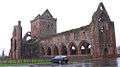 Sweetheart Abbey, Dumfries and Galloway (Scotland)
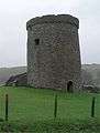 Orchardton Tower, Dumfries and Galloway, Scotland
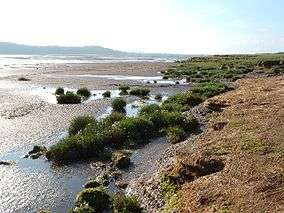 Caerlaverock National Nature Reserve. View across the Nith Estuary, close to the Solway Firth, Dumfries & Galloway.
 Tongland Power station.
 Mull of Galloway headland.
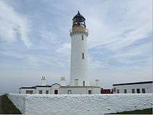 Mull of Galloway Lighthouse.
 A Machars beach.
 Machars Coastline looking south from Cruggleton Castle.
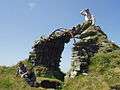 The remains of Cruggleton Castle.
 The Machars, as viewed from Torrs Warren with Luce Bay standing between.
 The Devil's Beef Tub.
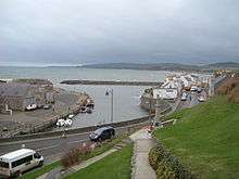 Port William harbour.
 River Nith Estuary.
See also
References
- ↑ http://www.visitsouthernscotland.com/
- ↑ http://www.mull-of-galloway.co.uk
- ↑ The Glenkens
- ↑ Society of Antiquaries of Scotland Proceedings of the Society Feb 11th 1924 ANCIENT BORDER HIGHWAYS by Harry R G Inglis Archived 12 June 2007 at the Wayback Machine.
- ↑ Information of Nith Estuary National Scenic area
- ↑ Roman Britain.org – Ward Law Archived 6 December 2009 at the Wayback Machine.
- ↑ Dumfries Museum – The Brow Well
- ↑ Forestry Commission web page on Mabie Forest and its facilities
- ↑ "Scotland's Natural Nature Reserves page on the Kirkconnell Flow". Archived from the original on 10 March 2010. Retrieved 23 December 2009.
- ↑ National Museum of Costume web site
- ↑ Information on East Stewartry National Scenic Area
- ↑ "Auchencairn Initiative walk from Balcary to Rascarrel". Archived from the original on 17 December 2009. Retrieved 23 December 2009.
- ↑ RSPB website – Mersehead page
- ↑ Information on Fleet Valley National Scenic Area
- ↑ http://www.visionofbritain.org.uk/types/type_page.jsp?unit_type=SCO_CNTY
- ↑ "Rallying cry from frog stronghold". BBC News. 6 May 2008.
- ↑ The RSPB: Mull of Galloway
- ↑ The RSPB: Wood of Cree
- ↑ The RSPB: Ken-Dee Marshes
- ↑ Website for the 7Stanes Mountain Bike Trails.
- ↑ Route 7 on Sustrans website Archived 10 March 2013 at the Wayback Machine.
- ↑ Website with walking routes in the Moffat hills
- ↑ Website on walking in the Durisdeer and Lowther hills
- ↑ Website with information on walking routes in the Carsphairn and Scaur hills
- ↑ Website with information on walking routes in the Galloway hills
- ↑ "Website for the Southern Upland Way". Archived from the original on 29 April 2012. Retrieved 23 February 2012.
- ↑ Annandale Way website
- ↑ Annandale Sailing Club's website
- ↑ Website for Loch Ken Marina
- ↑ Website for water ski-ing on Loch Ken
- ↑ Website for Crossmichael Marina Archived 10 March 2013 at the Wayback Machine.
- ↑ http://www.devilsporridge.co.uk/
- ↑ See also Local Governance (Scotland) Act 2004, Office of Public Sector Information (OPSI) website
- ↑ "VOTE 2003 – Dumfries & Galloway". BBC News.
- ↑ Rinaldi, Giancarlo (9 February 2006). "Tax defeat leads to resignation". BBC News.
- ↑ DGC -Document: By-Election For Abbey Ward – Result
- ↑ "Drive ban councillor quits posts". BBC News. 20 May 2008.
- ↑ "Councillor lands drink-drive ban". BBC News. 29 August 2008.
- ↑ "Dumfries and Galloway Council deadlock meeting planned". BBC News. 28 September 2013. Retrieved 28 September 2013.
- ↑ "Labour and SNP form Dumfries and Galloway Council coalition". BBC News. 1 October 2013.
- ↑ "SNP quits Dumfries and Galloway Council ruling coalition". BBC News. 2 June 2014.
External links
| Wikimedia Commons has media related to Dumfries and Galloway. |
- Local Authority website
- Dumfries and Galloway at Curlie (based on DMOZ)