Harrow, London
| Harrow | |
|---|---|
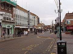 Harrow town centre | |
 Harrow Harrow shown within Greater London | |
| Population | 80,213 (Greenhill, Headstone South, West Harrow, Headstone North, Roxeth, Marlborough and Harrow on the Hill wards 2011)[1] |
| Demonym | Harrovian |
| OS grid reference | TQ145885 |
| • Charing Cross | 11 mi (18 km) ESE |
| London borough | |
| Ceremonial county | Greater London |
| Region | |
| Country | England |
| Sovereign state | United Kingdom |
| Post town | Harrow |
| Postcode district | HA1, HA2, HA3 |
| Dialling code | 020 |
| Police | Metropolitan |
| Fire | London |
| Ambulance | London |
| EU Parliament | London |
| UK Parliament | |
| London Assembly | |
Harrow (/ˈhæroʊ/[2]) is a large suburban town in the London Borough of Harrow, northwest London, England, 10.5 miles (16.9 km) northwest of Charing Cross. Harrow-on-the-Hill is a conservation area with listed buildings of Georgian architecture. The borough, which also includes Headstone North, Roxeth, Marlborough, Greenhill, Headstone South and West Harrow electoral wards, had a population of 80,213 at the 2011 census. Harrow was a municipal borough of Middlesex before its inclusion in Greater London in 1965. Harrow is home to a large University of Westminster campus, Harrow School and Harrow High School.
Etymology
Harrow's name comes from Old English hearg = "(heathen) temple", which was probably on the hill of Harrow, where St. Mary's Church stands today.[3] The name has been studied in detail by Keith Briggs.[4]
Arts and culture
The first and only contemporary artist-led gallery in Harrow was set up in 2010 by the Usurp Art Collective. The space is called the Usurp Art Gallery & Studios and is based in West Harrow, a bohemian part of Harrow. Usurp Art provides professional support to artists and runs the only public artists studios in the borough. It is a flagship project for Arts Council England.[5][6][7] Harrow has a Hindu temple dedicated to Sri Lord Ayyappa and is known as Sri Ayyappan Kovil, London
Geography
Neighbouring areas | |
|---|---|
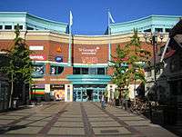
Harrow forms a commercial hub in northwest London, including a well-connected[n 1] town centre containing:
- two shopping centres
- Parades of shops throughout Station Road and the ascending, traditional College Road
- Over 300 m of a fully pedestranised shopping/café streets roads (north of St Ann's)
Harrow historically included Harrow on the Hill, which sits on top of an outlying knoll and is contiguous with the centre of Harrow. Much of Kenton and before 1716 all of Pinner were parts of Harrow, geographical facts which root the importance of Harrow as a meeting place and a place of business. Harrow Weald, is the district north of Wealdstone, both of which were historically also part of Harrow. Harrow may also include the wards of Roxeth, Marlborough, Headstone North and Harrow on the Hill as well as the Greenhill, West Harrow and Headstone South wards listed above. The combined population of these wards is 80,213 (2011).
Demography
In the 2011 census, the Greenhill ward (which covers most of the town centre) was 42% white (26% British, 13% Other, 3% Irish), 26% Indian, and 9% Other Asian.[8] The West Harrow ward (covering areas west from the centre) was 44% white (32% British, 8% Other, 4% Irish), 23% Indian, and 12% Other Asian.[9] In addition, Headstone South ward (northwest from centre) was 43% white (31% British, 9% Other, 3% Irish), 24% Indian and 9% Other Asian.[10] Harrow on the Hill ward was 47% white (34% British, 10% Other, 3% Irish), 19% Indian and 12% Other Asian.[11] These ethnicity statistics are not representative of the whole town or the other wards.
Economy and education
Major employers include Kodak Alaris, the Royal National Orthopaedic Hospital and Ladbrokes, which has its headquarters in Harrow.[12]
Harrow is home to a large University of Westminster campus and its oldest secondary schools are Harrow School and Harrow High School.
Transport
Rail and London Underground
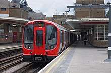
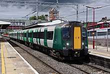
Harrow is served by a number of London Underground, London Overground and National Rail services:
- Harrow-on-the-Hill (Metropolitan line & Aylesbury Line/Chiltern Railways)[n 2]
- West Harrow (Metropolitan line)
- South Harrow (Piccadilly line)
- North Harrow (Metropolitan line)
- Harrow & Wealdstone (Bakerloo line, Watford DC line, London Northwestern Railway and Southern)
- Headstone Lane (London Overground)
A short railway line called the Stanmore branch line used to run from Harrow & Wealdstone to Stanmore Village, but this line was closed in 1964.[13]
Bus
Harrow bus station is close to St Anne's shopping centre and Harrow on the Hill railway station.[14]
Public services
Harrow borough is patrolled by the Metropolitan Police Service (the territorial police force in London). The service is provided through South Harrow Police Station and Fountain House, Headstone Drive, Kirkland House, Pinner Police Station, Waitrose, Northolt Road contact points supported by 22 Safer Neighbourhoods teams.[15]
Barnet is served by Northwick Park Hospital and specialists St Mark's Hospital and Royal National Orthopaedic Hospital, which are run by National Health Service. The local Harrow CCG manages public provision of homecare throughout Harrow which is state funded.[16]
Railway accidents
On 7 August 1838 Thomas Port died from injuries received in a train accident near Harrow. His gravestone in the parish churchyard of St Mary's, Harrow-on-the-Hill, states: "To the memory of Thomas Port, son of John Port of Burton-upon-Trent in the County of Stafford, Hat Manufacturer, who near this town had both legs severed from his body by the railway train. With great fortitude, he bore a second amputation by the surgeons and died from loss of blood, August 7th 1838, aged 33 years."
On 26 November 1870 two trains collided at Harrow & Wealdstone station, killing 9 and injuring 44.[17]
On 8 October 1952 three trains collided at Harrow and Wealdstone station, killing 112 people.[18] Of the dead, 64 were railway employees on their way to work.
Sports
The town has one association football team called Harrow Borough who currently play in the Isthmian League Premier Division.
Harrow was the birthplace of Everton winger Theo Walcott who was born in Stanmore, Harrow.
Notable people
Harrow is the hometown of renowned fashion designer Dame Vivienne Westwood, who in the 1970s became one of the pioneers of 'punk' culture and fashion.
Twin towns
Harrow is twinned with:
Notes and references
- Notes
- ↑ Harrow has a combined tube and a rail station named after the most historic part, Harrow on the Hill and 17 bus routes including a bus station.
- ↑ Not in Harrow on the Hill, as close to the foot of the hill and long outside of its ward boundary.
- References
- ↑ "Archived copy". Archived from the original on 22 February 2014. Retrieved 9 June 2014.
- ↑ Wells, John C. (2008), Longman Pronunciation Dictionary (3rd ed.), Longman, p. 368, ISBN 9781405881180
- ↑ Room, Adrian: "Dictionary of Place-Names in the British Isles", Bloomsbury, 1988. ISBN 0-7475-0170-X
- ↑ Briggs, Keith "Harrow", Journal of the English Place-name Society, volume 42 (2010), 43–64
- ↑ New art gallery opens in Harrow Archived 4 September 2012 at the UK Government Web Archive
- ↑ "All the news from Harrow – getwestlondon". Retrieved 16 November 2016.
- ↑ "Lifestyle: lifestyle news for West London – Get West London". Retrieved 16 November 2016.
- ↑ "Greenhill – UK Census Data 2011". Retrieved 16 November 2016.
- ↑ "West Harrow – UK Census Data 2011". Retrieved 16 November 2016.
- ↑ "Headstone South – UK Census Data 2011". Retrieved 16 November 2016.
- ↑ "Harrow on the Hill – UK Census Data 2011". Retrieved 16 November 2016.
- ↑ Draft Core Strategy Retrieved on 20 October 2013.
- ↑ "The Harrow and Stanmore railway". www.stanmoretouristboard.org.uk. The Stanmore Tourist Board. Archived from the original on 7 February 2018. Retrieved 7 February 2018.
- ↑ St Anne's, How to find us
- ↑ "Harrow Contact Us".
- ↑ https://www.harrowccg.nhs.uk/download.cfm?doc=docm93jijm4n10592&ver=24154
- ↑ "Accident at Harrow on 26th November 1870 :: The Railways Archive". Retrieved 16 November 2016.
- ↑ "1952: Many die as three trains crash at Harrow". BBC News. 8 October 2002. Retrieved 23 September 2018.
- ↑ "British towns twinned with French towns [via WaybackMachine.com]". Archant Community Media Ltd. Archived from the original on 5 July 2013. Retrieved 20 July 2013.
External links
| Districts |
|  | ||
|---|---|---|---|---|
| Attractions | ||||
| Parks and open spaces |
| |||
| Constituencies | ||||
| Tube and rail stations | ||||
| Other topics | ||||
| Academics |
| ||||
|---|---|---|---|---|---|
| Athletics | |||||
| Life | |||||
| People |
| ||||
| Affiliates | |||||
| |||||