Pidigan, Abra
| Pidigan | |
|---|---|
| Municipality | |
| Municipality of Pidigan | |
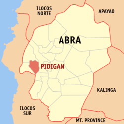 Map of Abra with Pidigan highlighted | |
.svg.png) Pidigan Location within the Philippines | |
| Coordinates: 17°34′N 120°35′E / 17.57°N 120.59°ECoordinates: 17°34′N 120°35′E / 17.57°N 120.59°E | |
| Country |
|
| Region | Cordillera Administrative Region (CAR) |
| Province | Abra |
| District | Lone District |
| Barangays | 15 (see Barangays) |
| Government [1] | |
| • Type | Sangguniang Bayan |
| • Mayor | Jannsen B. Valera |
| • Electorate | 7,980 voters (2016) |
| Area [2] | |
| • Total | 49.15 km2 (18.98 sq mi) |
| Population (2015 census)[3] | |
| • Total | 12,185 |
| • Density | 250/km2 (640/sq mi) |
| Time zone | UTC+8 (PST) |
| ZIP code | 2806 |
| PSGC | 140118000 |
| IDD : area code | +63 (0)74 |
| Climate type | Tropical rainforest climate |
| Income class | 5th municipal income class |
| Revenue (₱) | 56,412,850.64 (2016) |
| Native languages |
Itneg language Ilocano Tagalog |
Pidigan, officially the Municipality of Pidigan, (Ilokano: Ili ti Pidigan; Tagalog: Bayan ng Pidigan), is a 5th class municipality in the province of Abra, Philippines. According to the 2015 census, it has a population of 12,185 people.[3]
Geography
Pidigan is located at 17°34′N 120°35′E / 17.57°N 120.59°E.
According to the Philippine Statistics Authority, the municipality has a land area of 49.15 square kilometres (18.98 sq mi) [2] constituting 1.18% of the 4,165.25-square-kilometre- (1,608.21 sq mi) total area of Abra.
Barangays
Pidigan is politically subdivided into 15 barangays.[4]
| PSGC | Barangay | Population | ±% p.a. | |||
|---|---|---|---|---|---|---|
| 2015[3] | 2010[5] | |||||
| 140118001 | Alinaya | 7.6% | 920 | 996 | −1.50% | |
| 140118002 | Arab | 3.9% | 470 | 458 | 0.49% | |
| 140118004 | Garreta | 5.3% | 649 | 582 | 2.10% | |
| 140118005 | Immuli | 5.0% | 614 | 557 | 1.87% | |
| 140118007 | Laskig | 4.7% | 568 | 484 | 3.09% | |
| 140118009 | Monggoc | 9.7% | 1,182 | 1,101 | 1.36% | |
| 140118008 | Naguirayan | 5.4% | 652 | 698 | −1.29% | |
| 140118010 | Pamutic | 5.2% | 637 | 566 | 2.28% | |
| 140118011 | Pangtud | 11.3% | 1,372 | 1,070 | 4.85% | |
| 140118012 | Poblacion East | 13.3% | 1,623 | 1,603 | 0.24% | |
| 140118013 | Poblacion West | 10.3% | 1,259 | 1,228 | 0.48% | |
| 140118014 | San Diego | 4.2% | 513 | 442 | 2.88% | |
| 140118016 | Sulbec | 5.6% | 682 | 675 | 0.20% | |
| 140118018 | Suyo (Malidong) | 5.4% | 664 | 625 | 1.16% | |
| 140118019 | Yuyeng | 3.1% | 380 | 443 | −2.88% | |
| Total | 12,185 | 11,528 | 1.06% | |||
Demographics
| Population census of Pidigan | ||
|---|---|---|
| Year | Pop. | ±% p.a. |
| 1903 | 2,639 | — |
| 1918 | 3,864 | +2.57% |
| 1939 | 3,994 | +0.16% |
| 1948 | 3,473 | −1.54% |
| 1960 | 5,414 | +3.77% |
| 1970 | 6,605 | +2.01% |
| 1975 | 6,897 | +0.87% |
| 1980 | 7,162 | +0.76% |
| 1990 | 8,807 | +2.09% |
| 1995 | 9,098 | +0.61% |
| 2000 | 10,183 | +2.44% |
| 2007 | 11,280 | +1.42% |
| 2010 | 11,528 | +0.79% |
| 2015 | 12,185 | +1.06% |
| Source: Philippine Statistics Authority[3][5][6][7] | ||
In the 2015 census, Pidigan had a population of 12,185.[3] The population density was 250 inhabitants per square kilometre (650/sq mi).
List of Cultural Properties of Pidigan
| Cultural Property wmph identifier |
Site name | Description | Province | City/Municipality | Address/Location | Coordinates | Image |
|---|---|---|---|---|---|---|---|
| Pidigan Church | Immaculate Conception Church | Abra | Pidigan | Corner Santiago McKinley St. | 17°34′15″N 120°35′21″E / 17.570712°N 120.589175°E | 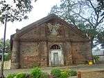 | |
| St. Mary High School | Abra | Pidigan | 17°34′15″N 120°35′23″E / 17.570749°N 120.589731°E |  | |||
| Bringas Ancestral House Ruins | The house of former municipal mayor Jeremias Bringas. It was used as a provincial capitol when Pidigan was made the temporary seat of the Provincial Government of Abra in 1945.[8] | Abra | Pidigan | 17°34′11″N 120°35′26″E / 17.56959°N 120.590578°E | 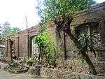 | ||
| Paaralan Sentral ng Pidigan/Pidigan Central School | Abra | Pidigan | 17°34′10″N 120°35′24″E / 17.569531°N 120.590068°E | 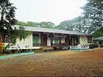 | |||
| Figueras Ancestral House | Old house owned by Sinforoso Figueras, the first municipal mayor of Pidigan from 1913 to 1919 and from 1943 to 1945.[8] | Abra | Pidigan | Paredes St. | 17°34′12″N 120°35′24″E / 17.569944°N 120.590101°E | 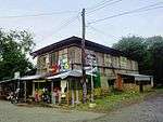 |
References
- ↑ "Municipality". Quezon City, Philippines: Department of the Interior and Local Government. Retrieved 31 May 2013.
- 1 2 "Province: Abra". PSGC Interactive. Quezon City, Philippines: Philippine Statistics Authority. Retrieved 12 November 2016.
- 1 2 3 4 5 Census of Population (2015). "Cordillera Administrative Region (CAR)". Total Population by Province, City, Municipality and Barangay. PSA. Retrieved 20 June 2016.
- ↑ "Municipal: Pidigan, Abra". PSGC Interactive. Quezon City, Philippines: Philippine Statistics Authority. Retrieved 8 January 2016.
- 1 2 Census of Population and Housing (2010). "Cordillera Administrative Region (CAR)". Total Population by Province, City, Municipality and Barangay. NSO. Retrieved 29 June 2016.
- ↑ Censuses of Population (1903–2007). "Cordillera Administrative Region (CAR)". Table 1. Population Enumerated in Various Censuses by Province/Highly Urbanized City: 1903 to 2007. NSO.
- ↑ "Province of Abra". Municipality Population Data. Local Water Utilities Administration Research Division. Retrieved 17 December 2016.
- 1 2 "Municipality of Pidigan, Abra". Department of the Interior and Local Government. Archived from the original on 30 April 2015. Retrieved 30 April 2015.
External links
| Wikimedia Commons has media related to Pidigan, Abra. |
Places adjacent to Pidigan, Abra | |
|---|---|
Bangued (capital) | |
| Municipalities | |
| Barangays | |
This article is issued from
Wikipedia.
The text is licensed under Creative Commons - Attribution - Sharealike.
Additional terms may apply for the media files.