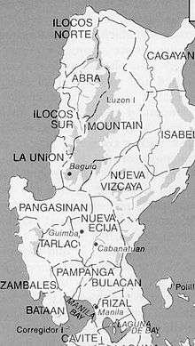
An old U.S. Army map showing Mountain province covering the present areas of Benguet, Ifugao, Kalinga and Apayao
During the Spanish occupation of the Philippines, Christianization and eventual subjugation of the mountain region proved difficult for the Spanish colonial government.[3] Several comandancias were established by the Spanish colonial government in strategic areas of the mountain region. Among them were Amburayan, Cabugaoan, Kayapa, Quiangan, Itaves, Apayaos, Lepanto, Benguet, Bontoc, Banaue, and Tiagan.[4][5][6]
On August 18, 1908 during the American regime, Mountain Province was established by the Philippine Commission with the enactment of Act No. 1876. Ifugao, which was part of Nueva Vizcaya province,[7] and the former Spanish comandancias of Amburayan, Apayao, Benguet, Bontoc, Kalinga and Lepanto, were annexed to the newly created province as sub-provinces.[8][9] Amburayan was later abolished in 1920 and its corresponding territories were transferred to the provinces of Ilocos Sur and La Union. Lepanto was also reduced in size and its towns were integrated into the sub-provinces of Bontoc and Benguet, and to the province of Ilocos Sur.[3][10][11]
On June 18, 1966, Republic Act No. 4695 was enacted to split Mountain Province and create four separate and independent provinces namely Benguet, Ifugao, Kalinga-Apayao, and Mountain Province.[12][13] Ifugao and Kalinga-Apayao were placed under the jurisdiction of the Cagayan Valley region,[14] with Benguet and Mountain Province placed under the Ilocos Region.
Modern history
On February 14, 1995, Kalinga-Apayao, one of the five provinces of the region was split into two separate and independent provinces of Apayao and Kalinga with the enactment of Republic Act No. 7878.[16][17]
Several attempts at legalizing autonomy in the Cordillera region have failed in two separate plebiscites.[18][19] An affirmative vote for the law on regional autonomy is a precondition by the 1987 Philippine Constitution to give the region autonomy in self-governance much like the Autonomous Region of Muslim Mindanao in southern Philippines. The first law Republic Act No. 6766, took effect on October 23, 1989[20] but failed to muster a majority vote in the plebiscite on January 30, 1990.[18][19] The second law, Republic Act No. 8438 passed by Congress of the Philippines on December 22, 1997,[21] also failed to pass the approval of the Cordillera peoples in a region-wide referendum on March 7, 1998.[18][19]
At present, a third organic act of the Cordillera is in the offing supported by the Cordillera Regional Development Council.
Recent events
In September 2000, the municipal council of Itogon, Benguet, withdrew support for the San Roque Dam project. The project had met a lot of resistance, because of the reported failure of its proponents to update its Environmental Certificate of Compliance (ECC) and to submit a watershed management plan required for a project of that magnitude. The San Roque Dam was to become one of the biggest dams in the world and would threaten the living environment of the Igorot.
The Cordillera Peoples Alliance (CPA), an indigenous rights organization in the region, in co-operation with other organizations, had highly resisted this project and thus booked a little victory. However, in May 2001, president Arroyo declared that the San Roque Dam project would continue anyway because it had already started and therefore was difficult to stop. At the same time she promised to not sacrifice the environment, to resettle the people who will lose their houses, to compensate other people, and to initiate no other large-scale irrigation projects in the future.
In December 2000, the Supreme Court of the Philippines dismissed a petition that questioned the constitutional legality of the Indigenous Peoples Rights Act (IPRA), and act which came into existence in 1997 giving the peoples of the Cordillera decisive influence over the establishment of foreign mining companies. In this act, ownership over the lands was regarded as communal, rather than individual and thus coincided more with the view on ownership of the Igorot. The IPRA was totally different in tone than the 1995 Mining Code.
Without consultation from the people of the Cordilleras, the Mining Code gave companies the freedom to devastate tribal lands, allowed 100% foreign ownership, and gave companies the right to displace and resettle people within their concessionary areas. Some influential people filed a lawsuit with the Supreme Court against the IPRA, because it contradicted with the Mining Code and would therefore be unlawful. The petition was dismissed in a 7-7 vote by the Supreme Court.
A bill creating an autonomous Cordillera was filed in Congress in 2014, but it was not backed by strategic politicians in the region due to lack of support from the national government. However, in 2017, all provincial congressmen within the CAR jointly filed a new Bill creating an autonomous Cordillera, the first time in three decades where all provincial district representatives called in unison for autonomy. The move was made due to the election win of President Duterte, who publicly supported the creation of an autonomous Cordillera. However, questions lingered on the issue of Nueva Viscaya's exclusion from the proposed region, despite being culturally and geographically part of the Cordilleras, leaving Nueva Viscaya Igorots left out from the proposal.[22][23]
Geography
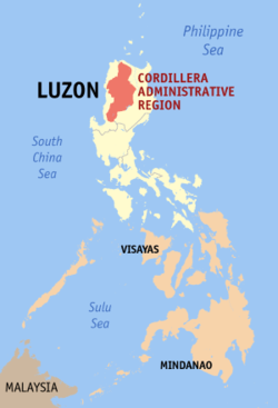
Cordillera Administrative Region is the only landlocked region in the Philippines, bounded on the northeast and east by the Cagayan Valley, and on the southwest and west by the Ilocos Region.
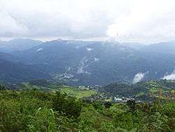
The region is primarily mountainous, situated within the Cordillera Central mountain range. Mount Pulag, the highest mountain in Luzon, is located at the tri-point of Benguet, Ifugao, and Nueva Vizcaya provinces.
Within the region are several streams and rivers. The most extensive is the Chico River, a major tributary of the Cagayan River, traversing the provinces of Mountain Province and Kalinga. Other major rivers include Agno, Amburayan, Bued in Benguet, Abulog in Kalinga, Abra River in Abra, Ahin River in Ifugao, Apayao River in Apayao, and Siffu River in both Ifugao and Mountain Province.[24][25]
Administrative divisions
Cordillera Administrative Region is politically subdivided into 6 provinces. It has 2 cities; the highly urbanized city of Baguio, and the component city of Tabuk. There are 1,176 barangays in the region. Geographically, the western half of Nueva Viscaya is part of the main Cordilleras, while its eastern half is part of the Caraballos, the meeting point of the Cordilleras and the Sierra Madre. There have been moves to reunify Nueva Vizcaya with the Cordilleras, however, no such legislation has yet been introduced in Congress.
| Province or HUC |
Capital |
Population (2015)[1]
|
Area[26] |
Density |
Cities |
Muni. |
Bgy. |
|
|
|
|
km2 |
sq mi |
/km2 |
/sq mi |
|
|
|
| Abra |
Bangued |
7001140000000000000♠14.0% | 241,160 |
4,165.25 |
1,608.21 |
58 |
150 |
0 |
27 |
303 |
| Apayao |
Kabugao |
7000690000000000000♠6.9% | 119,184 |
4,413.35 |
1,704.00 |
27 |
70 |
0 |
7 |
133 |
| Benguet |
La Trinidad |
7001259000000000000♠25.9% | 446,224 |
2,769.08 |
1,069.15 |
160 |
410 |
1 |
13 |
140 |
| Ifugao |
Lagawe |
7001118000000000000♠11.8% | 202,802 |
2,628.21 |
1,014.76 |
77 |
200 |
0 |
11 |
175 |
| Kalinga |
Tabuk |
7001124000000000000♠12.4% | 212,680 |
3,231.25 |
1,247.59 |
66 |
170 |
1 |
7 |
152 |
| Mountain Province |
Bontoc |
7000900000000000000♠9.0% | 154,590 |
2,157.38 |
832.97 |
72 |
190 |
0 |
10 |
144 |
| Baguio |
† |
— |
7001201000000000000♠20.1% | 345,366 |
57.51 |
22.20 |
6,000 |
16,000 |
— |
— |
129 |
| Total |
1,722,006 |
19,422.03 |
7,498.89 |
89 |
230 |
2 |
75 |
1,176 |
|
† Baguio is a highly-urbanized city; figures are excluded from Benguet. |
| City/Municipality |
Population (2015)[1]
|
Area[27] |
Density |
Class |
Income class |
Province |
|
|
km2 |
sq mi |
/km2 |
/sq mi |
|
|
|
| Aguinaldo |
19,408 |
538.05 |
207.74 |
36 |
93 |
Municipality |
2nd |
Ifugao |
| Alfonso Lista |
32,119 |
347.46 |
134.16 |
92 |
240 |
Municipality |
3rd |
Ifugao |
| Asipulo |
15,261 |
182.87 |
70.61 |
83 |
210 |
Municipality |
5th |
Ifugao |
| Atok |
19,668 |
214.99 |
83.01 |
91 |
240 |
Municipality |
4th |
Benguet |
| Baguio City |
345,366 |
57.51 |
22.20 |
6,000 |
16,000 |
Highly Urbanized City |
1st |
Benguet |
| Bakun |
15,357 |
286.91 |
110.78 |
54 |
140 |
Municipality |
3rd |
Benguet |
| Balbalan |
12,195 |
542.69 |
209.53 |
22 |
57 |
Municipality |
3rd |
Kalinga |
| Banaue |
21,837 |
191.20 |
73.82 |
110 |
280 |
Municipality |
4th |
Ifugao |
| Bangued |
48,163 |
105.70 |
40.81 |
460 |
1,200 |
Municipality |
1st |
Abra |
| Barlig |
4,819 |
228.64 |
88.28 |
21 |
54 |
Municipality |
5th |
Mountain Province |
| Bauko |
31,065 |
153.00 |
59.07 |
200 |
520 |
Municipality |
4th |
Mountain Province |
| Besao |
7,040 |
173.62 |
67.04 |
41 |
110 |
Municipality |
5th |
Mountain Province |
| Bokod |
13,756 |
274.96 |
106.16 |
50 |
130 |
Municipality |
4th |
Benguet |
| Boliney |
3,573 |
216.92 |
83.75 |
16 |
41 |
Municipality |
5th |
Abra |
| Bontoc |
24,643 |
396.10 |
152.94 |
62 |
160 |
Municipality |
2nd |
Mountain Province |
| Bucay |
17,115 |
102.16 |
39.44 |
170 |
440 |
Municipality |
5th |
Abra |
| Bucloc |
2,501 |
63.77 |
24.62 |
39 |
100 |
Municipality |
6th |
Abra |
| Buguias |
43,627 |
175.88 |
67.91 |
250 |
650 |
Municipality |
3rd |
Benguet |
| Calanasan |
12,604 |
1,256.15 |
485.00 |
10 |
26 |
Municipality |
1st |
Apayao |
| Conner |
26,051 |
694.30 |
268.07 |
38 |
98 |
Municipality |
2nd |
Apayao |
| Daguioman |
2,088 |
114.37 |
44.16 |
18 |
47 |
Municipality |
5th |
Abra |
| Danglas |
4,192 |
156.02 |
60.24 |
27 |
70 |
Municipality |
5th |
Abra |
| Dolores |
11,315 |
47.45 |
18.32 |
240 |
620 |
Municipality |
5th |
Abra |
| Flora |
17,391 |
324.40 |
125.25 |
54 |
140 |
Municipality |
3rd |
Apayao |
| Hingyon |
9,227 |
62.02 |
23.95 |
150 |
390 |
Municipality |
5th |
Ifugao |
| Hungduan |
9,400 |
260.30 |
100.50 |
36 |
93 |
Municipality |
4th |
Ifugao |
| Itogon |
59,820 |
449.73 |
173.64 |
130 |
340 |
Municipality |
1st |
Benguet |
| Kabayan |
15,260 |
242.69 |
93.70 |
63 |
160 |
Municipality |
4th |
Benguet |
| Kabugao |
15,537 |
935.12 |
361.05 |
17 |
44 |
Municipality |
1st |
Apayao |
| Kapangan |
19,361 |
164.39 |
63.47 |
120 |
310 |
Municipality |
4th |
Benguet |
| Kiangan |
17,048 |
200.00 |
77.22 |
85 |
220 |
Municipality |
4th |
Ifugao |
| Kibungan |
17,292 |
254.86 |
98.40 |
68 |
180 |
Municipality |
4th |
Benguet |
| La Paz |
15,437 |
51.41 |
19.85 |
300 |
780 |
Municipality |
5th |
Abra |
| La Trinidad |
129,133 |
70.04 |
27.04 |
1,800 |
4,700 |
Municipality |
1st |
Benguet |
| Lacub |
3,403 |
295.30 |
114.02 |
12 |
31 |
Municipality |
5th |
Abra |
| Lagangilang |
14,255 |
101.44 |
39.17 |
140 |
360 |
Municipality |
5th |
Abra |
| Lagawe |
19,333 |
208.91 |
80.66 |
93 |
240 |
Municipality |
4th |
Ifugao |
| Lagayan |
4,499 |
215.97 |
83.39 |
21 |
54 |
Municipality |
5th |
Abra |
| Lamut |
25,279 |
159.65 |
61.64 |
160 |
410 |
Municipality |
4th |
Ifugao |
| Langiden |
3,198 |
116.29 |
44.90 |
28 |
73 |
Municipality |
5th |
Abra |
| Licuan-Baay |
4,689 |
256.42 |
99.00 |
18 |
47 |
Municipality |
5th |
Abra |
| Luba |
6,339 |
148.27 |
57.25 |
43 |
110 |
Municipality |
5th |
Abra |
| Lubuagan |
8,733 |
234.20 |
90.43 |
37 |
96 |
Municipality |
4th |
Kalinga |
| Luna |
19,063 |
606.04 |
233.99 |
31 |
80 |
Municipality |
2nd |
Apayao |
| Malibcong |
3,428 |
283.17 |
109.33 |
12 |
31 |
Municipality |
5th |
Abra |
| Manabo |
10,761 |
110.95 |
42.84 |
97 |
250 |
Municipality |
5th |
Abra |
| Mankayan |
35,953 |
130.48 |
50.38 |
280 |
730 |
Municipality |
1st |
Benguet |
| Mayoyao |
17,331 |
238.05 |
91.91 |
73 |
190 |
Municipality |
4th |
Ifugao |
| Natonin |
10,272 |
252.00 |
97.30 |
41 |
110 |
Municipality |
4th |
Mountain Province |
| Paracelis |
28,121 |
570.16 |
220.14 |
49 |
130 |
Municipality |
2nd |
Mountain Province |
| Pasil |
9,644 |
189.00 |
72.97 |
51 |
130 |
Municipality |
5th |
Kalinga |
| Peñarrubia |
6,640 |
38.29 |
14.78 |
170 |
440 |
Municipality |
6th |
Abra |
| Pidigan |
12,185 |
49.15 |
18.98 |
250 |
650 |
Municipality |
5th |
Abra |
| Pilar |
10,223 |
66.10 |
25.52 |
150 |
390 |
Municipality |
5th |
Abra |
| Pinukpuk |
32,026 |
743.56 |
287.09 |
43 |
110 |
Municipality |
1st |
Kalinga |
| Pudtol |
14,925 |
401.02 |
154.83 |
37 |
96 |
Municipality |
4th |
Apayao |
| Rizal |
17,038 |
231.00 |
89.19 |
74 |
190 |
Municipality |
4th |
Kalinga |
| Sabangan |
9,315 |
72.04 |
27.81 |
130 |
340 |
Municipality |
5th |
Mountain Province |
| Sablan |
11,457 |
105.63 |
40.78 |
110 |
280 |
Municipality |
5th |
Benguet |
| Sadanga |
8,799 |
83.30 |
32.16 |
110 |
280 |
Municipality |
5th |
Mountain Province |
| Sallapadan |
6,622 |
128.62 |
49.66 |
51 |
130 |
Municipality |
5th |
Abra |
| San Isidro |
4,574 |
48.07 |
18.56 |
95 |
250 |
Municipality |
5th |
Abra |
| San Juan |
9,867 |
64.08 |
24.74 |
150 |
390 |
Municipality |
5th |
Abra |
| San Quintin |
5,438 |
66.59 |
25.71 |
82 |
210 |
Municipality |
5th |
Abra |
| Santa Marcela |
13,613 |
196.32 |
75.80 |
69 |
180 |
Municipality |
4th |
Apayao |
| Tadian |
19,389 |
145.20 |
56.06 |
130 |
340 |
Municipality |
4th |
Mountain Province |
| Tanudan |
9,534 |
307.55 |
118.75 |
31 |
80 |
Municipality |
4th |
Kalinga |
| Tayum |
14,467 |
61.14 |
23.61 |
240 |
620 |
Municipality |
5th |
Abra |
| Tineg |
5,097 |
744.80 |
287.57 |
6.8 |
18 |
Municipality |
2nd |
Abra |
| Tinglayan |
12,868 |
283.00 |
109.27 |
45 |
120 |
Municipality |
4th |
Kalinga |
| Tinoc |
16,559 |
239.70 |
92.55 |
69 |
180 |
Municipality |
4th |
Ifugao |
| Tuba |
47,648 |
295.97 |
114.27 |
160 |
410 |
Municipality |
1st |
Benguet |
| Tublay |
17,892 |
102.55 |
39.59 |
170 |
440 |
Municipality |
5th |
Benguet |
| Tubo |
5,699 |
409.87 |
158.25 |
14 |
36 |
Municipality |
4th |
Abra |
| Villaviciosa |
5,392 |
102.93 |
39.74 |
52 |
130 |
Municipality |
5th |
Abra |
| Tabuk City |
110,642 |
700.25 |
270.37 |
160 |
410 |
Component City |
5th |
Kalinga |
Demographics
Population census of
Cordillera Administrative Region |
|---|
| Year | Pop. | ±% |
|---|
| 1990 | 1,146,191 | — |
|---|
| 2000 | 1,365,412 | +19.1% |
|---|
| 2010 | 1,616,867 | +18.4% |
|---|
| 2015 | 1,722,006 | +6.5% |
|---|
| Source: Philippine Statistics Authority[28] |
Ethnic groups
Cordillera is home to many ethnic tribes living on the Cordillera mountain range. They are commonly referred to as the Igorot.
Ethnic people of Abra
The Tingguians are composed of sub-groups known as the Itneg tribes which includes Adasen, Balatok, Banaw, Belwang, Binungan, Gubang, Inlaud, Mabaka, Maeng, Masadiit, and Muyadan or Ammutan.:[29] Their places in Abra are as follows:
- Adasen — Lagayan, Lagangilang, San Juan and Tineg
- Banaw — Daguioman, Malibcong, also found in Balbalan, Kalinga
- Binungan — Baay-Licuan and Lacub
- Balatok — in the villages of Amti, Kilong-olaw, & Danak, all in Boliney
- Belwang — in the village of Dao-angan in Boliney
- Gubang — Malibcong
- Inlaud — Lagangilang and Peñarrubia, in Lumaba village of Villaviciosa, in the villages of Abang and Patoc in Bucay, in Langiden, San Isidro, San Quintin, Danglas (also found in some parts of Nueva Era)
- Mabaka — Lacub and Malibcong
- Maeng — Luba, Tubo and Villaviciosa, (also found in San Emilio, Ilocos Sur, Banayoyo and other towns in Ilocos Sur)
- Masadiit — Sallapadan, Bucloc and in the village of Sapdaan in Manabo, and in barangays Poblacion, Bawiyan, and Dumagas in Boliney
- Ammutan a.k.a. Muyadan tribe — in Manabo
Ethnic people of Apayao
- Isnag tribe — also known as Isneg comprising the sub-groups known as the Ymandaya and Imallod (Isnag refers to the people, while Isneg refers to the dialect). Isnags are found not only in Apayao but also in the eastern section of Ilocos Norte and northwestern portion of Cagayan. Their places of abode in Apayao are as follows:
- Ymandaya (Isnag) — Calanasan (Bayag)
- Imallod (Isnag) — Kabugao, Conner, Pudtol, and some parts of Luna (Macatel)
- Malaweg — Conner
Ethnic People of Ifugao
- Tuwali
- Ayangan
- Kalanguya
|
Ethnic people of Kalinga
- Tubog Tribe
- Banao
- Tanudan
- Tongrayan Tribe
- Ifutfut (Fugnay, Ngifat), Also found in Lacnog, Tabuk
- Iterkaw ;Also Found in Nambaran, Tabuk
- Ifasao ; Also Found in Isla, Appas Tabuk
- Ichananaw ;Also Found in Lacnog, Tabuk
- Itongrayan (Luprupa,Ifunug,Amfato), Also Found in Damsite, Tabuk
- Isumacher tribe ( Sumacher, Filong, Man-ufer, Mallango, Fangad) ; Also Found in Madopdop Lacnog, Ipil, Bayabat, Tannubong, Bulo Tabuk
Ethnic people of Mountain Province
- Bontoc — Bontoc
- Balangao — Natonin
- Baliwon — Paracelis
- Applai — Bauko, Besao, Sabangan and Sagada
|
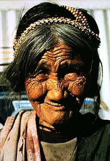 A Bontoc woman with a snake skeleton in her hair. Skeletons serve as a charm against lightning. |
Languages
The Cordillera region is the most diversified ethno-linguistic region in the Philippines with its major languages having sub-dialect variations. The topographic formation of the Cordillera mountain range, which has greatly influenced the upstream migration of peoples in the Cordillera into the hinterland, corresponds the various dialects pattern formation. The disparity in linguistic ethnicity however, did not form variation in cultural development as almost every Cordillera people shares similar cultural identity among different tribes.
- Balangao, spoken in Natonin, Mountain Province.
- Bontoc, spoken in Bontoc, Mountain Province.
- Ibaloi, spoken in Benguet.
- Ifugao, spoken in Ifugao.
- Ilocano, spoken in Apayao, Abra, Kalinga, Mountain Province, Benguet, and Ifugao. It is the regional lingua franca.
- Isnag, spoken in Apayao.
- Itneg, spoken in Abra.
- Kalinga, spoken in Kalinga.
- Kalanguya, spoken in some parts of Benguet.
- Kankanaey, spoken in western Mountain Province and some parts of Benguet.
|
Religion
Roman Catholic is the single largest denomination in this region. However unlike most other provinces and regions of the Philippines, they only form a slight majority in the region forming 60%-70% of the population while Protestants specifically Anglicans and Evangelicals have a very strong presence that forms 20%-30% of the population.[31][32]. Other religions such as traitional Animism have a significant presence in the region and it's mainly practiced by tribal people.
Regional economy
Economy of the region is diverse; mining, agriculture, export processing zone, tourism are among economic activities in the different provinces of the region.
The region is abundant with mineral reserves. These include metallic ores such as gold, copper, silver, zinc, and non-metallic minerals like sand, gravel and sulfur. Mineral reserves are found in all the provinces. However, mining is concentrated in Benguet.
Its timber resources has dwindled since the introduction of slash-and-burn method of farming in all parts of the Cordillera mountain range.
Vegetable crop production is well developed in Benguet, rice production in Ifugao and Abra, corn production in Mountain Province, and Kalinga.
Baguio and La Trinidad are considered as the industrial centers in the region. Baguio City hosts Baguio Export Processing Zone where operations of big companies like Texas Instruments, and MOOG are located. The city also hosts offshore and outsourcing companies operating call centers.
The primary growth centers of the region are Metro Baguio and the Eastern Cordillera Growth Corridor.
Culture

The Bontoc Museum, run by the Sisters of the Immaculate Heart of Mary, hosts many of the materials used by the different Ethnic Tribes in the Mountain Province.
The Cordillera region is known for its unique musical instruments including the gangsa kalinga, nose flute, bamboo flute, buzzer, bangibang, tongatong, diwdiw-as, saggeypo, and bamboo zither.
Tourism
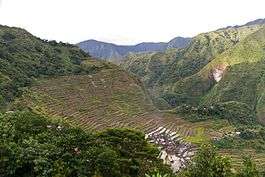
The Banaue Rice Terraces is among the sites visited by tourists in the region which is situated in the province of Ifugao. The terraces, ancient sprawling man-made structures from 2,000 to 6,000 years old, are a UNESCO World Heritage Site, and are part of the Rice Terraces of the Philippine Cordilleras. The Philippine Eagle and the Crested-Serpent Eagle was also found in the Last forest frontier of the North the Province of Apayao.
Other natural attractions of the region include the Sumaguing Cave in Sagada and the mummy caves of Benguet and Mountain Province. There are four national parks: Cassamata Hill, Mount Data, Balbalasang-Balbalan, located in the province of Kalinga, and Mount Pulag, the highest mountain in Luzon at 2,922 metres (9,587 ft) above sea level. Kalinga also offers white water rafting along the Chico River.
The city of Baguio, dubbed the "summer capital of the Philippines", is a major tourist destination in the region.
References
- 1 2 3
Census of Population (2015). "Cordillera Administrative Region (CAR)". Total Population by Province, City, Municipality and Barangay. PSA. Retrieved 20 June 2016.
- 1 2 "Regional Profile: Cordillera Administrative Region (CAR)". CountrySTAT Philippines. Archived from the original on 22 October 2014. Retrieved 18 September 2014.
- 1 2 "Mt. Province". VisitMyPhilippines.com The Ultimate Travel Guide for Tourists. Department of Tourism. Retrieved 23 December 2013.
- ↑ Keesing, Felix Maxwell; Keesing, Marie Margaret; Keesing, Marie Martin; Institute of Pacific Relations (contributor); International Research Committee (contributor) (1934). Taming Philippine Headhunters: A Study of Government and of Cultural Change in Northern Luzon. Stanford University Press. pp. 67–69. ISBN 9780804721103. Retrieved 2 January 2015.
- ↑ "Benguet History". Province of Benguet (official website). Archived from the original on 19 October 2014. Retrieved 22 October 2014.
Benguet was once part of Mountain Province.
- ↑ "Historical Background". Provincial Government of Apayao. Archived from the original on 4 January 2015. Retrieved 3 January 2015.
- ↑ National Historical Institute (Philippines) [contributor] (1978). Kasaysayan, Volume 3, Issues 1-4 (Digitized by Google on 26 Sep 2009). National Historical Institute. p. 16. Retrieved 2 January 2015.
(Original file from the University of Michigan)
- ↑ Ingles, Raul Rafael (2008). 1908 :The Way it Really was : Historical Journal for the UP Centennial, 1908-2008. Diliman, Quezon City: University of the Philippines Press. pp. 330, 339. ISBN 9715425801. Retrieved 2 January 2015.
- ↑ Worcester, Dean C.; Philippine Commission (1908). Seventh Annual Report of the Secretary of the Interior to the Philippine Commission for the Fiscal Year Ended June 30, 1908 (Digitized by Google on 23 Nov 2005 (Original file from the University of Michigan)). Manila: U.S. Government Printing Office. pp. 17–19. Retrieved 2 January 2015.
(Google Books link
- ↑ Philippines. Census Office; Buencamino, Felipe; Villamor, Ignacio (1920). Census of the Philippine Islands Taken Under the Direction of the Philippine Legislature in the Year 1918, Volume 1. Bureau of printing. p. 68.
- ↑ "Cordillera Administrative Region History". Cordillera Connection (Blogspot). 14 August 2009. Retrieved 22 October 2014.
- ↑ "Republic Act No. 4695: An Act Creating the Provinces of Benguet, Mountain Province, Ifugao and Kalinga-Apayao". Chan Robles Virtual Law Library. Retrieved 18 September 2014.
- ↑ "Facts & Figures: Ifugao Province". Philippine Statistics Authority - National Statistical Coordination Board. Department of the Interior and Local Government - Cordillera Administrative Region. Retrieved 2 January 2015.
- ↑ "Historical Background". Provincial Government of Apayao. 15 April 2013. Archived from the original on 4 January 2015. Retrieved 3 January 2015.
- ↑ "The Cordillera Administrative Region (CAR)". Department of Agriculture. Retrieved 18 September 2014.
- ↑ "R.A. No. 7878: An Act Converting the Sub-Provinces of Kalinga and Apayao into Regular Provinces to be Known as the Province of Kalinga and the Province of Apayao, Amending for the Purpose Republic Act No. 4695". Chan Robles Virtual Law Library. 14 February 1995. Retrieved 4 January 2015.
- ↑ "Facts & Figures: Apayao Province". Philippine Statistics Authority - National Statistical Coordination Board. 19 April 2012. Retrieved 4 January 2015.
- 1 2 3 Ferrer, Miriam Coronel (4 September 2010). "Cordillera autonomy - Miriam Coronel Ferrer". ABS-CBN News. Retrieved 4 January 2015.
- 1 2 3 "Cordillera Autonomy". Scribd Inc. Dona Dee Lacdao. Retrieved 4 January 2015.
- ↑ "R.A. No. 6766: An Act Providing for an Organic Act for the Cordillera Autonomous Region". The LawPhil Project. Congress of the Philippines. Retrieved 4 January 2015.
- ↑ "R.A. No. 8438: An Act to Establish the Cordillera Autonomous Region". The LawPhil Project. Congress of the Philippines. Retrieved 4 January 2015.
- ↑ http://www.albeebenitez.ph/news/creation-cordillera-autonomous-region-pushed
- ↑ http://northluzon.politics.com.ph/mayor-domogan-optimistic-on-ok-of-cordillera-autonomous-region-bill-with-p75b-investments/
- ↑ Cordillera People's Alliance, Public Information Commission (1 January 2001). "Dams In the Cordillera" (PDF). International Rivers. Archived from the original (PDF) on 4 January 2015. Retrieved 4 January 2015.
- ↑ "Cordillera's Water Resources". Cordillera Peoples Alliance. Retrieved 4 January 2015.
- ↑ "PSGC Interactive; List of Provinces". Philippine Statistics Authority. Archived from the original on 21 January 2013. Retrieved 29 March 2016.
- ↑ "PSGC Interactive; List of Cities". Philippine Statistics Authority. Archived from the original on 29 April 2011. Retrieved 29 March 2016.
- ↑ "Population and Annual Growth Rates for The Philippines and Its Regions, Provinces, and Highly Urbanized Cities" (PDF). 2010 Census and Housing Population. Philippine Statistics Authority. Archived from the original (PDF) on 28 September 2013. Retrieved 9 August 2013.
- ↑ "Archived copy". Archived from the original on 2011-11-16. Retrieved 2012-01-14.
- ↑ "Archived copy". Archived from the original on 2015-01-15. Retrieved 2015-01-15.
- ↑ "Intriguing Patterns in Scolbert08's Map of Religion in Insular Southeast Asia". GeoCurrents. Retrieved 2017-12-06.
- ↑ http://philchal.org/dawn/nationalsum.asp