Bucay, Abra
| Bucay | ||
|---|---|---|
| Municipality | ||
| Municipality of Bucay | ||
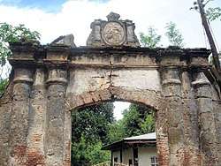 Casa Real arch | ||
| ||
 Map of Abra with Bucay highlighted | ||
.svg.png) Bucay Location within the Philippines | ||
| Coordinates: 17°32′N 120°43′E / 17.54°N 120.72°ECoordinates: 17°32′N 120°43′E / 17.54°N 120.72°E | ||
| Country |
| |
| Region | Cordillera Administrative Region (CAR) | |
| Province | Abra | |
| District | Lone District | |
| Barangays | 21 (see Barangays) | |
| Government [1] | ||
| • Type | Sangguniang Bayan | |
| • Mayor | Victorion B. Baroña Jr. | |
| • Electorate | 11,456 voters (2016) | |
| Area [2] | ||
| • Total | 102.16 km2 (39.44 sq mi) | |
| Population (2015 census)[3] | ||
| • Total | 17,115 | |
| • Density | 170/km2 (430/sq mi) | |
| Time zone | UTC+8 (PST) | |
| ZIP code | 2805 | |
| PSGC | 140103000 | |
| IDD : area code | +63 (0)74 | |
| Climate type | Tropical rainforest climate | |
| Income class | 5th municipal income class | |
| Revenue (₱) | 70,818,040.82 (2016) | |
| Native languages |
Itneg language Ilocano Tagalog | |

Bucay, officially the Municipality of Bucay, (Ilokano: Ili ti Bucay; Tagalog: Bayan ng Bucay), is a 5th class municipality in the province of Abra, Philippines. According to the 2015 census, it has a population of 17,115 people.[3]
History
Bucay was established on October 29, 1846 and the first settlers were Itnegs. It became the first provincial capital of Abra when the military form of government was set up in May 1847. At the back of the present municipal hall is the centuries-old façade of the ruined Casa Real (Provincial Capitol Building). Across the town plaza, stand the centuries-old Catholic church, convent and learning school, Spanish structure house owned by then Don Teodoro Arias who served as Gobernadorcillo of Bucay in 1862, and the old American structure house which was built in 1908 and owned by then US Corporal Ernest D. Smith who served the Spanish–American War and the Filipino-American war from 1896 to 1901. Prior to the invasion of the Spaniards, the place had become footfalls of invading headhunters from the dense jungles of the Cordillera range.
There are two versions on how this town got its name as "Bucay". Some residents say that there was a tribe leader by the name of Bucay. When this leader was still young, while patrolling, he found a pretty young lass lying on the way which prompted him to extend assistance, and brought her home. After a period of time, he developed his love with the young lass and took her as his wife. In several occasions, the girl suddenly disappeared. At some instances, Bucay used to see her at the corner of his bamboo hut sitting alone with her bowed head which prompted him to approach and touch her, but always disappeared.
Geography
Among the twenty-seven (27) towns of Abra, Bucay is the most centrally located, situated at 17°32′N 120°43′E / 17.54°N 120.72°E. It is bounded on the north by the towns of Tayum and Lagangilang, on the south by Manabo, on the east by Licuan-Baay and Sallapadan, and on the west by Peñarrubia, Bangued and Villaviciosa.
According to the Philippine Statistics Authority, the municipality has a land area of 102.16 square kilometres (39.44 sq mi) [2] constituting 2.45% of the 4,165.25-square-kilometre- (1,608.21 sq mi) total area of Abra.
Barangays
Bucay is politically subdivided into 21 barangays.[4]
| PSGC | Barangay | Population | ±% p.a. | |||
|---|---|---|---|---|---|---|
| 2015[3] | 2010[5] | |||||
| 140103001 | Abang | 4.4% | 752 | 820 | −1.63% | |
| 140103002 | Bangbangcag | 6.3% | 1,082 | 1,088 | −0.11% | |
| 140103003 | Bangcagan | 3.7% | 639 | 616 | 0.70% | |
| 140103004 | Banglolao | 3.3% | 570 | 598 | −0.91% | |
| 140103005 | Bugbog | 4.3% | 742 | 698 | 1.17% | |
| 140103006 | Calao | 4.6% | 788 | 721 | 1.71% | |
| 140103007 | Dugong | 8.9% | 1,520 | 1,532 | −0.15% | |
| 140103008 | Labon | 3.9% | 669 | 632 | 1.09% | |
| 140103009 | Layugan | 5.4% | 917 | 1,002 | −1.67% | |
| 140103010 | Madalipay | 2.3% | 397 | 369 | 1.40% | |
| 140103016 | North Poblacion | 5.7% | 983 | 1,123 | −2.50% | |
| 140103011 | Pagala | 6.7% | 1,145 | 1,262 | −1.84% | |
| 140103013 | Pakiling | 4.7% | 809 | 708 | 2.57% | |
| 140103012 | Palaquio | 6.1% | 1,042 | 994 | 0.90% | |
| 140103014 | Patoc | 4.4% | 759 | 787 | −0.69% | |
| 140103018 | Quimloong | 3.0% | 505 | 526 | −0.77% | |
| 140103019 | Salnec | 2.2% | 376 | 370 | 0.31% | |
| 140103020 | San Miguel | 4.3% | 733 | 653 | 2.22% | |
| 140103021 | Siblong | 5.7% | 972 | 972 | 0.00% | |
| 140103017 | South Poblacion | 3.5% | 592 | 579 | 0.42% | |
| 140103022 | Tabiog | 6.6% | 1,123 | 1,076 | 0.82% | |
| Total | 17,115 | 17,126 | −0.01% | |||
Demographics
| Population census of Bucay | ||
|---|---|---|
| Year | Pop. | ±% p.a. |
| 1903 | 4,483 | — |
| 1918 | 5,653 | +1.56% |
| 1939 | 5,570 | −0.07% |
| 1948 | 6,215 | +1.22% |
| 1960 | 7,473 | +1.55% |
| 1970 | 9,937 | +2.89% |
| 1975 | 11,337 | +2.68% |
| 1980 | 12,375 | +1.77% |
| 1990 | 13,346 | +0.76% |
| 1995 | 14,499 | +1.56% |
| 2000 | 14,881 | +0.56% |
| 2007 | 16,266 | +1.23% |
| 2010 | 17,126 | +1.89% |
| 2015 | 17,115 | −0.01% |
| Source: Philippine Statistics Authority[3] [5] [6] [7] | ||
In the 2015 census, Bucay had a population of 17,115.[3] The population density was 170 inhabitants per square kilometre (440/sq mi).
Attractions
- Borikibok Mini Park and Cave
- Roces Cave
- Casa Real
- Mini Park along boundary Bucay & Peñarrubia
- Nagsangalan falls
References
- ↑ "Municipality". Quezon City, Philippines: Department of the Interior and Local Government. Retrieved 31 May 2013.
- 1 2 "Province: Abra". PSGC Interactive. Quezon City, Philippines: Philippine Statistics Authority. Retrieved 12 November 2016.
- 1 2 3 4 5 Census of Population (2015). "Cordillera Administrative Region (CAR)". Total Population by Province, City, Municipality and Barangay. PSA. Retrieved 20 June 2016.
- ↑ "Municipal: Bucay, Abra". PSGC Interactive. Quezon City, Philippines: Philippine Statistics Authority. Retrieved 8 January 2016.
- 1 2 Census of Population and Housing (2010). "Cordillera Administrative Region (CAR)". Total Population by Province, City, Municipality and Barangay. NSO. Retrieved 29 June 2016.
- ↑ Censuses of Population (1903–2007). "Cordillera Administrative Region (CAR)". Table 1. Population Enumerated in Various Censuses by Province/Highly Urbanized City: 1903 to 2007. NSO.
- ↑ "Province of Abra". Municipality Population Data. Local Water Utilities Administration Research Division. Retrieved 17 December 2016.
External links
| Wikimedia Commons has media related to Bucay, Abra. |
Places adjacent to Bucay, Abra | |
|---|---|
Bangued (capital) | |
| Municipalities | |
| Barangays | |