Tuba, Benguet
| Tuba | ||
|---|---|---|
| Municipality | ||
| Municipality of Tuba | ||
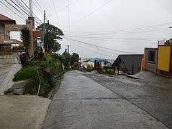 Poblacion | ||
| ||
| Nickname(s): Gateway to Baguio[1][2] | ||
 Map of Benguet with Tuba highlighted | ||
.svg.png) Tuba Location within the Philippines | ||
| Coordinates: 16°19′N 120°33′E / 16.32°N 120.55°ECoordinates: 16°19′N 120°33′E / 16.32°N 120.55°E | ||
| Country |
| |
| Region | Cordillera Administrative Region (CAR) | |
| Province | Benguet | |
| District | Lone District | |
| Founded | 1911 | |
| Barangays | 13 (see Barangays) | |
| Government [3] | ||
| • Type | Sangguniang Bayan | |
| • Mayor | Ignacio R. Rivera | |
| • Electorate | 23,210 voters (2016) | |
| Area [4] | ||
| • Total | 295.97 km2 (114.27 sq mi) | |
| Population (2015 census)[5] | ||
| • Total | 47,648 | |
| • Density | 160/km2 (420/sq mi) | |
| Time zone | UTC+8 (PST) | |
| ZIP code | 2603 | |
| PSGC | 141113000 | |
| IDD : area code | +63 (0)74 | |
| Climate | Am | |
| Income class | 1st municipal income class | |
| Revenue (₱) | 160,532,737.71 (2016) | |
| Native languages |
Kankanaey language Ibaloi Ilocano Tagalog | |
| Website |
www | |

Tuba, officially the Municipality of Tuba, (Ilokano: Ili ti Tuba; Filipino: Bayan ng Tuba), is a 1st class municipality in the province of Benguet, Philippines. According to the 2015 census, it has a population of 47,648 people.[5]
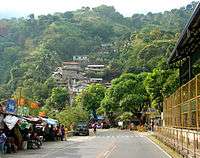
Tuba is known as the "Gateway to Baguio", as the Ben Palispis Highway or Marcos Highway and Kennon Road, two main access highways of the adjacent city of Baguio, are largely traversed in the municipality.[1][2]
History
Tuba was originally a barrio[6] of the township of Baguio in the early 1900s under the American Occupation of the Philippines.[7] It was separated from Baguio upon the latter's conversion into a chartered city on September 1, 1909,[8] and became part of the township of Twin Peaks in Benguet.[6]
Twin Peaks was abolished as a township on December 11, 1911 with the issuance of Executive Order No. 77 by American Governor General William Cameron Forbes, creating the township of Tuba.[6][7]
On June 25, 1963, President Diosdado Macapagal issued Executive Order No. 42 and by operation of Section 2 of Republic Act No. 1515, the municipal District of Tuba was converted into a regular municipality.[9]
Geography
Tuba is located at 16°19′N 120°33′E / 16.32°N 120.55°E, at the south-western tip of both Benguet and the Central Cordillera Mountain Range. South of the municipality lies the province of Pangasinan and to the west lies the Ilocos rolling hills of the province of La Union. It is bordered on the north by Sablan and La Trinidad; east by Baguio and Itogon; and south by Sison and San Manuel.
According to the Philippine Statistics Authority, the municipality has a land area of 295.97 square kilometres (114.27 sq mi) [4] constituting 10.69% of the 2,769.08-square-kilometre- (1,069.15 sq mi) total area of Benguet.
The municipality's urban area comprises the barangays of Poblacion and Camp 3, having a composite land area of 83.85 square kilometres (32.37 sq mi), or 19.31% of the total land area.
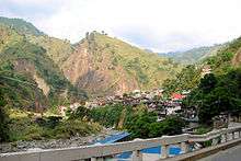
Topography
.jpeg)
Tuba's topography is generally characterized by irregular rugged terrain and steep slopes with several mountain peaks rising from the table land itself. Mount Santo Tomas, the highest peak in the municipality[10] soars to 2,252 metres (7,388 ft) above sea level.[11]
Four major rivers/streams and 49 tributary/minor rivers and creeks intersect the landform and serve as the drains of the municipality.
Climate
Tuba has 2 pronounced seasons - wet and dry. The dry season starts in November and lasts until April while the wet season lasts from May to October.
Barangays
Tuba is politically subdivided into 13 barangays.[12]
| PSGC | Barangay | Population | ±% p.a. | |||
|---|---|---|---|---|---|---|
| 2015[5] | 2010[13] | |||||
| 141113001 | Ansagan | 5.0% | 2,386 | 2,083 | 2.62% | |
| 141113002 | Camp One | 3.7% | 1,773 | 1,742 | 0.34% | |
| 141113003 | Camp 3 | 21.1% | 10,033 | 10,413 | −0.71% | |
| 141113004 | Camp 4 | 15.0% | 7,136 | 5,973 | 3.45% | |
| 141113006 | Nangalisan | 5.1% | 2,433 | 2,428 | 0.04% | |
| 141113007 | Poblacion | 16.2% | 7,711 | 5,958 | 5.03% | |
| 141113008 | San Pascual | 2.4% | 1,148 | 1,080 | 1.17% | |
| 141113009 | Tabaan Norte | 3.0% | 1,422 | 1,133 | 4.42% | |
| 141113010 | Tabaan Sur | 2.8% | 1,315 | 1,264 | 0.76% | |
| 141113011 | Tadiangan | 14.1% | 6,721 | 5,685 | 3.24% | |
| 141113012 | Taloy Norte | 2.9% | 1,396 | 1,307 | 1.26% | |
| 141113013 | Taloy Sur | 6.3% | 2,990 | 2,681 | 2.10% | |
| 141113014 | Twin Peaks | 2.5% | 1,184 | 1,127 | 0.94% | |
| Total | 47,648 | 42,874 | 2.03% | |||
Demographics
| Population census of Tuba | ||
|---|---|---|
| Year | Pop. | ±% p.a. |
| 1918 | 2,764 | — |
| 1939 | 5,936 | +3.71% |
| 1948 | 4,888 | −2.14% |
| 1960 | 9,307 | +5.51% |
| 1970 | 17,939 | +6.77% |
| 1975 | 25,304 | +7.14% |
| 1980 | 30,449 | +3.77% |
| 1990 | 39,635 | +2.67% |
| 1995 | 39,589 | −0.02% |
| 2000 | 38,366 | −0.67% |
| 2007 | 40,008 | +0.58% |
| 2010 | 42,874 | +2.55% |
| 2015 | 47,648 | +2.03% |
| Source: Philippine Statistics Authority[5][13][14][15] | ||
In the 2015 census, Tuba had a population of 47,648.[5] The population density was 160 inhabitants per square kilometre (410/sq mi).
Economy
Mining is a major contributor to the economy of Tuba.[16] The town's mining industry began upon the discovery of gold in the province of Benguet during the early 1930s.[17] Since 1958, Philex Mining Corporation, the largest gold and copper producer in the Philippines, has been operating the first underground block cave mine in the Far East at Padcal in Barangay Camp 3.[18][19]
A few abandoned mining sites such as those of Benguet Exploration Mine and Black Mountain, Inc. have been left unattended for years, which pose a threat to the local population and the environment.[20]
The presence of waterfalls, hot springs and natural caves in the municipality boosts tourism.[2][21] Mount Cabuyao and Mount Santo Tomas, the highest mountain in the town, are frequently visited by mountaineers.[22][23]
Education
Public schools
As of 2014, Tuba has 32 public elementary schools and 6 public secondary schools.[24][25][26]
|
|
Transportation
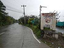
The three major highways that connect the lowlands to Baguio City pass through the municipality.[27]
| Highway | Barangays traversed (downhill from Baguio City) |
|---|---|
| Kennon Road |
|
| Aspiras-Palispis Highway |
|
| Naguilian Road |
|
Gallery
 Municipal hall
 Public market
 Tuba Central School
 Conversion of Saint Paul Parish Church
 Highland landscape and vegetation
References
- 1 2 Galacgac, Aure (14 November 2011). "Gateway to Baguio marks centennial". Sun.Star Baguio. Archived from the original on 6 October 2014. Retrieved 3 October 2014.
- 1 2 3 Laking, Jimmy (10 August 2014). "Tuba to clear 2-story structure blocking Bridal Veil Falls' view". Baguio Midland Courier. Archived from the original on 7 August 2016. Retrieved 3 October 2014.
- ↑ "Municipality". Quezon City, Philippines: Department of the Interior and Local Government. Retrieved 31 May 2013.
- 1 2 "Province: Benguet". PSGC Interactive. Quezon City, Philippines: Philippine Statistics Authority. Retrieved 12 November 2016.
- 1 2 3 4 5 Census of Population (2015). "Cordillera Administrative Region (CAR)". Total Population by Province, City, Municipality and Barangay. PSA. Retrieved 20 June 2016.
- 1 2 3 "LGU-Pugo-History". Provincial Government of La Union (official website). Archived from the original on 6 March 2016. Retrieved 3 October 2014.
(Note: Pugo was part of the municipal district of Benguet Province until February 4, 1920)
- 1 2 "The Municipality of Tuba". Municipality of Tuba, Benguet (official website). Archived from the original on 15 October 2016. Retrieved 3 October 2014.
- ↑ "Facts & Figures: Benguet Province". Philippine Statistics Authority (National Statistical Coordination Board - Cordillera Administrative Region). Archived from the original on 28 February 2016. Retrieved 3 October 2014.
- ↑ "Executive Order No. 42, s. 1963: Declaring Certain Municipal Districts in the Philippines as Municipalities". Official Gazette of the Republic of the Philippines. Archived from the original on 12 October 2016. Retrieved 25 October 2014.
- ↑ "Barangay Poblacion profile". Municipality of Tuba website. Archived from the original on 15 October 2016. Retrieved 16 September 2014.
- ↑ "Mt. Cabuyao (2,025 +) / Mt. Sto. Tomas (2,256 +)". Pinoymountaineer.com. 19 April 2008. Archived from the original on 15 May 2016. Retrieved 16 September 2014.
- ↑ "Municipal: Tuba, Benguet". PSGC Interactive. Quezon City, Philippines: Philippine Statistics Authority. Retrieved 8 January 2016.
- 1 2 Census of Population and Housing (2010). "Cordillera Administrative Region (CAR)". Total Population by Province, City, Municipality and Barangay. NSO. Retrieved 29 June 2016.
- ↑ Censuses of Population (1903–2007). "Cordillera Administrative Region (CAR)". Table 1. Population Enumerated in Various Censuses by Province/Highly Urbanized City: 1903 to 2007. NSO.
- ↑ "Province of Benguet". Municipality Population Data. Local Water Utilities Administration Research Division. Retrieved 17 December 2016.
- ↑ "Mining Seen to Boost Local Economy". Mechanics Hub. 19 January 2010. Archived from the original on 6 October 2014. Retrieved 4 October 2014.
- ↑ "Municipality of Tuba, Benguet". Department of Interior and Local Government - Cordillera Administrative Region. Archived from the original on 11 December 2015. Retrieved 4 October 2014.
- ↑ "Philex Mining Corp". Chamber of Mines of the Philippines. Chamber of Mines of the Philippines. Archived from the original on 4 March 2016. Retrieved 16 September 2014.
- ↑ "Pacdal Mines". Philex Mining Corporation. Philex Mining Corporation. Archived from the original on 4 March 2016. Retrieved 16 September 2014.
- ↑ Beleo, Salvacion (10 January 2012). "Abandoned mining sites endanger people and environment - solon". House of Representatives of the Philippines (official website). Archived from the original on 4 March 2016. Retrieved 4 October 2014.
- ↑ "Benguet: Tourist Attractions". VisitMyPhilippines. Archived from the original on 16 October 2016. Retrieved 4 October 2014.
- ↑ Llanes, Jonathan (24 April 2013). "A Mt. Sto. Tomas sojourn". Sun.Star Baguio. Archived from the original on 6 October 2014. Retrieved 4 October 2014.
- ↑ "Mt. Cabuyao (2,025 +) / Mt. Sto. Tomas (2,256 +)". PinoyMountaineer. 19 April 2008. Archived from the original on 15 May 2016. Retrieved 4 October 2014.
- ↑ "Masterlist of Public Elementary Schools for the School year 2012- 2013" (XLSX). Department of Education (Philippines), July 15, 2013. Retrieved 28 December 2014.
- 1 2 "Masterlist of Secondary Schools (School Year 2013- 2014)". Department of Education (Philippines), July 4, 2013. Archived from the original (XLSX) on 1 July 2014. Retrieved 20 November 2014.
- 1 2 "Masterlist of Public Schools SY 2013-2014" (XLSX). Department of Education (Philippines), 22 October 2014. Retrieved 28 December 2014.
- ↑ "Tuba, Benguet". Mapcentral. Retrieved 3 October 2014.
External links

Places adjacent to Tuba, Benguet | |
|---|---|
La Trinidad (capital) | |
| Municipalities | |
| Highly urbanized city |
|
| Barangays | |