Bokod, Benguet
| Bokod | ||
|---|---|---|
| Municipality | ||
| Municipality of Bokod | ||
 | ||
| ||
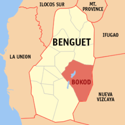 Map of Benguet with Bokod highlighted | ||
.svg.png) Bokod Location within the Philippines | ||
| Coordinates: 16°30′N 120°50′E / 16.5°N 120.83°ECoordinates: 16°30′N 120°50′E / 16.5°N 120.83°E | ||
| Country |
| |
| Region | Cordillera Administrative Region (CAR) | |
| Province | Benguet | |
| District | Lone District | |
| Founded | 1960 | |
| Barangays | 10 (see Barangays) | |
| Government [1] | ||
| • Type | Sangguniang Bayan | |
| • Mayor | Thomas Wales Jr. | |
| • Electorate | 9,025 voters (2016) | |
| Area [2] | ||
| • Total | 274.96 km2 (106.16 sq mi) | |
| Population (2015 census)[3] | ||
| • Total | 13,756 | |
| • Density | 50/km2 (130/sq mi) | |
| Time zone | UTC+8 (PST) | |
| ZIP code | 2605 | |
| PSGC | 141104000 | |
| IDD : area code | +63 (0)74 | |
| Climate | Am | |
| Income class | 4th municipal income class | |
| Revenue (₱) | 106,426,689.65 (2016) | |
| Native languages |
Kankanaey language Ibaloi Kallahan language Tagalog | |
| Website |
www | |

Bokod, officially the Municipality of Bokod, (Ilokano: Ili ti Bokod; Filipino: Bayan ng Bokod), is a 4th class municipality in the province of Benguet, Philippines. According to the 2015 census, it has a population of 13,756 people.[3]
History
Pre-colonial and Spanish periods
According to folklore, Bokod, once a heavily-forested village, got its name from a man named Ebokot (or Ekbot), who introduced agricultural development to the area.[4] Ebokot's name was associated with the village and was registered as a pueblo during the Spanish Regime.[5]
American period
Bokod was established as one of the 19 townships of Benguet during the American Rule with the enactment of Act No. 48 on November 22, 1900.[4][5][6][7]
On August 13, 1908, Benguet was established as a sub-province of the newly created Mountain Province with the enactment of Act No. 1876. As a result, six townships of Benguet were abolished, among them were Ambuklao and Daclan which were integrated into the township of Bokod.[4][5][7]
Post-war era
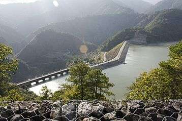
One of the principal infrastructure in Bokod is the Ambuklao Dam. Built in 1950 and opened in 1956, it is one of the most important hydroelectric facilities in Luzon.
On June 25, 1963, President Diosdado Macapagal issued Executive Order No. 42 converting eight (8) of the thirteen (13) towns (designated as municipal districts) of Benguet sub-province into regular municipalities. Bokod was among them.[8]
On June 18, 1966, the sub-province of Benguet was separated from the old Mountain Province and was converted into a regular province. Bokod remained to be a component municipality of the newly established province.[9]
Geography
Bokod is located at 16°30′N 120°50′E / 16.5°N 120.83°E. It is bounded by Kabayan on the north-east, Atok on the north-west, Tublay on the mid-west, Itogon on the south-west, and Kayapa on the east.
According to the Philippine Statistics Authority, the municipality has a land area of 274.96 square kilometres (106.16 sq mi) [2] constituting 9.93% of the 2,769.08-square-kilometre- (1,069.15 sq mi) total area of Benguet.
Barangays
Bokod is politically subdivided into 10 barangays.[10]
| PSGC | Barangay | Population | ±% p.a. | |||
|---|---|---|---|---|---|---|
| 2015[3] | 2010[11] | |||||
| 141104001 | Ambuclao | 23.0% | 3,167 | 3,013 | 0.95% | |
| 141104002 | Bila | 10.2% | 1,405 | 991 | 6.87% | |
| 141104003 | Bobok‑Bisal | 9.1% | 1,254 | 1,086 | 2.78% | |
| 141104004 | Daclan | 13.3% | 1,824 | 1,748 | 0.81% | |
| 141104005 | Ekip | 6.1% | 834 | 806 | 0.65% | |
| 141104006 | Karao | 7.2% | 989 | 958 | 0.61% | |
| 141104007 | Nawal | 4.2% | 581 | 743 | −4.57% | |
| 141104008 | Pito | 7.9% | 1,092 | 838 | 5.17% | |
| 141104009 | Poblacion | 14.8% | 2,036 | 1,964 | 0.69% | |
| 141104010 | Tikey | 4.2% | 574 | 501 | 2.62% | |
| Total | 13,756 | 12,648 | 1.61% | |||
Demographics
| Population census of Bokod | |||||||||||||||||||||||||||||||||||||||||||||||||
|---|---|---|---|---|---|---|---|---|---|---|---|---|---|---|---|---|---|---|---|---|---|---|---|---|---|---|---|---|---|---|---|---|---|---|---|---|---|---|---|---|---|---|---|---|---|---|---|---|---|
|
| ||||||||||||||||||||||||||||||||||||||||||||||||
| Source: Philippine Statistics Authority[3] [11] [12] [13] | |||||||||||||||||||||||||||||||||||||||||||||||||
In the 2015 census, Bokod had a population of 13,756.[3] The population density was 50 inhabitants per square kilometre (130/sq mi).
Attractions
- Ambuklao Dam
- Mount Amalkatan
- Badekbek Sulfur Springs
- Palansa Panoramic View
- Bila Mountain Saddle
- Ekip Mossy Forest
- Palpalan Waterfalls
- Adwagan River
- Bobbok Second Growth Pine Forests
- Mount Pulag
- Mount Purgatory
- Mount Patoktok
Education
Public schools
As of 2014, Bokod has 37 public elementary schools and 3 public secondary schools.[14][15][16]
|
|
Universities
- Benguet State University Bokod Campus (BSAT) (Ambangeg)
Private schools
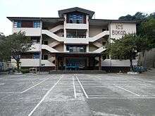
- Immaculate Conception School of Bokod, Inc. (Poblacion)
Gallery
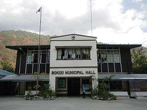 Municipal hall
 Downtown Bokod
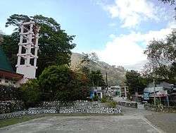
 Immaculate Conception Parish Church
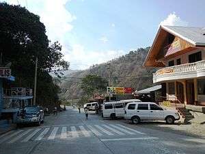 A road in town
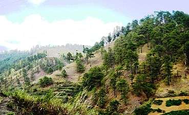 Pine forests in Bokod
References
- ↑ "Municipality". Quezon City, Philippines: Department of the Interior and Local Government. Retrieved 31 May 2013.
- 1 2 "Province: Benguet". PSGC Interactive. Quezon City, Philippines: Philippine Statistics Authority. Retrieved 12 November 2016.
- 1 2 3 4 5 Census of Population (2015). "Cordillera Administrative Region (CAR)". Total Population by Province, City, Municipality and Barangay. PSA. Retrieved 20 June 2016.
- 1 2 3 "Municipality of Bokod". Province of Benguet (official website). Archived from the original on 11 November 2014. Retrieved 16 October 2018.
- 1 2 3 "Municipality of Bokod, Benguet". Department of Interior and Local Government - Cordillera Administrative Region. Archived from the original on 7 October 2014. Retrieved 1 November 2014.
- ↑ "Facts & Figures: Benguet Province". Philippine Statistics Authority - National Statistical Coordination Board - Cordillera Administrative Region. Archived from the original on 28 February 2016. Retrieved 16 October 2018.
- 1 2 "History: Benguet Province". Province of Benguet (official website). Archived from the original on 19 October 2014. Retrieved 16 October 2018.
- ↑ "Executive Order No. 42, s. 1963: Declaring Certain Municipal Districts in the Philippines as Municipalities". Official Gazette of the Republic of the Philippines. Archived from the original on 12 October 2016. Retrieved 16 October 2018.
- ↑ "Republic Act No. 4695: An Act Creating the Provinces of Benguet, Mountain Province, Ifugao and Kalinga-Apayao". Chan Robles Virtual Law Library. 18 June 1966. Archived from the original on 4 March 2016. Retrieved 12 December 2016.
- ↑ "Municipal: Bokod, Benguet". PSGC Interactive. Quezon City, Philippines: Philippine Statistics Authority. Retrieved 8 January 2016.
- 1 2 Census of Population and Housing (2010). "Cordillera Administrative Region (CAR)". Total Population by Province, City, Municipality and Barangay. NSO. Retrieved 29 June 2016.
- ↑ Censuses of Population (1903–2007). "Cordillera Administrative Region (CAR)". Table 1. Population Enumerated in Various Censuses by Province/Highly Urbanized City: 1903 to 2007. NSO.
- ↑ "Province of Benguet". Municipality Population Data. Local Water Utilities Administration Research Division. Retrieved 17 December 2016.
- ↑ "Masterlist of Public Elementary Schools for the School year 2012- 2013" (XLSX). Department of Education (Philippines), July 15, 2013. Retrieved 28 December 2014.
- 1 2 "Masterlist of Secondary Schools (School Year 2013- 2014)". Department of Education (Philippines), July 4, 2013. Archived from the original (XLSX) on 1 July 2014. Retrieved 20 November 2014.
- 1 2 "Masterlist of Public Schools SY 2013-2014" (XLSX). Department of Education (Philippines), 22 October 2014. Retrieved 28 December 2014.
External links
| Wikimedia Commons has media related to Bokod, Benguet. |
Places adjacent to Bokod, Benguet | |
|---|---|
La Trinidad (capital) | |
| Municipalities | |
| Highly urbanized city |
|
| Barangays | |