Minamimaki, Nagano
| Minamimaki 南牧村 | |||
|---|---|---|---|
| Village | |||
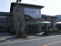 Minamimaki Village Hall | |||
| |||
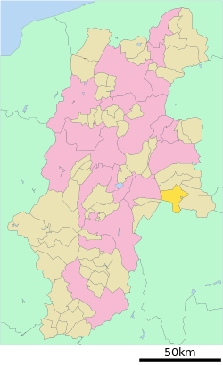 Location of Minamimaki in Nagano Prefecture | |||
 Minamimaki | |||
| Coordinates: 36°1′15″N 138°29′31.7″E / 36.02083°N 138.492139°ECoordinates: 36°1′15″N 138°29′31.7″E / 36.02083°N 138.492139°E | |||
| Country | Japan | ||
| Region | Chūbu (Kōshin'etsu) | ||
| Prefecture | Nagano | ||
| District | Minamisaku | ||
| Area | |||
| • Total | 133.09 km2 (51.39 sq mi) | ||
| Population (October 2016) | |||
| • Total | 3,374 | ||
| • Density | 25.4/km2 (66/sq mi) | ||
| Time zone | UTC+9 (Japan Standard Time) | ||
| Symbols | |||
| • Tree | Prunus serrulata | ||
| • Flower | Lily of the valley | ||
| • Bird | Eurasian skylark | ||
| Phone number | 0267-78-2121 | ||
| Address | 1051 Uminokuchi Minamimaki-mura, Minamisaku-gun, Nagano-ken 384-1211 | ||
| Website | http://www.minamimakimura.jp/ | ||


Rural scene in Minamimaki village
Minamimaki (南牧村 Minamimaki-mura) is a village located in Nagano Prefecture, Japan. As of 1 October 2016, the village had an estimated population of 3,374, and a population density of 25.4 persons per km². Its total area is 133.09 square kilometres (51.39 sq mi).
Geography
Minamimaki is located in mountainous eastern Nagano Prefecture, bordered by Yamanashi Prefecture to the south. The Southern Yatsugatake Volcanic Group is partly located within this village.
Surrounding municipalities
Climate
| Climate data for Nobeyama (1981 - 2010), altitude 1350 meters | |||||||||||||
|---|---|---|---|---|---|---|---|---|---|---|---|---|---|
| Month | Jan | Feb | Mar | Apr | May | Jun | Jul | Aug | Sep | Oct | Nov | Dec | Year |
| Record high °C (°F) | 11.9 (53.4) |
15.6 (60.1) |
20.1 (68.2) |
24.9 (76.8) |
26.0 (78.8) |
28.6 (83.5) |
30.7 (87.3) |
31.0 (87.8) |
29.1 (84.4) |
24.9 (76.8) |
19.7 (67.5) |
16.9 (62.4) |
31.0 (87.8) |
| Average high °C (°F) | −0.1 (31.8) |
0.5 (32.9) |
4.7 (40.5) |
11.9 (53.4) |
16.5 (61.7) |
19.5 (67.1) |
23.1 (73.6) |
24.2 (75.6) |
19.8 (67.6) |
14.1 (57.4) |
9.1 (48.4) |
3.4 (38.1) |
12.3 (54.1) |
| Daily mean °C (°F) | −5.3 (22.5) |
−4.9 (23.2) |
−0.8 (30.6) |
5.6 (42.1) |
10.6 (51.1) |
14.5 (58.1) |
18.4 (65.1) |
19.2 (66.6) |
15.2 (59.4) |
8.8 (47.8) |
3.5 (38.3) |
−2.0 (28.4) |
6.9 (44.4) |
| Average low °C (°F) | −11.9 (10.6) |
−11.5 (11.3) |
−6.7 (19.9) |
−0.6 (30.9) |
4.7 (40.5) |
9.9 (49.8) |
14.5 (58.1) |
15.2 (59.4) |
11.2 (52.2) |
3.8 (38.8) |
−2.1 (28.2) |
−8.1 (17.4) |
1.5 (34.7) |
| Record low °C (°F) | −25.1 (−13.2) |
−26.0 (−14.8) |
−25.3 (−13.5) |
−18.7 (−1.7) |
−6.6 (20.1) |
−0.5 (31.1) |
4.8 (40.6) |
5.0 (41) |
−2.2 (28) |
−8.9 (16) |
−14.1 (6.6) |
−23.1 (−9.6) |
−26.0 (−14.8) |
| Average precipitation mm (inches) | 50.3 (1.98) |
56.2 (2.213) |
98.1 (3.862) |
102.3 (4.028) |
127.5 (5.02) |
174.9 (6.886) |
202.1 (7.957) |
176.0 (6.929) |
210.5 (8.287) |
136.7 (5.382) |
66.9 (2.634) |
38.4 (1.512) |
1,439.9 (56.689) |
| Average precipitation days (≥ 1.0 mm) | 6.9 | 7.2 | 11.5 | 10.5 | 11.4 | 13.9 | 15.8 | 12.8 | 12.6 | 9.9 | 8.0 | 5.9 | 126.4 |
| Mean monthly sunshine hours | 168.9 | 161.3 | 179.3 | 191.8 | 176.7 | 131.5 | 142.0 | 168.5 | 124.3 | 141.9 | 164.0 | 173.5 | 1,924.4 |
| Source #1: Japan Meteorological Agency | |||||||||||||
| Source #2: 観測史上1位~10位の値 | |||||||||||||
Politics and Government
Elections
History
The area of present-day MInamimaki was part of ancient Shinano Province. The modern village of Minamimaki was created with the establishment of the municipalities system on April 1, 1889.
Transportation
Railway
- The village does not have any passenger rail service.
Highway
Local attractions
External links

- Official Website (in Japanese)
| Core city | |
|---|---|
| Special city | |
| Cities | |
| Districts | |
This article is issued from
Wikipedia.
The text is licensed under Creative Commons - Attribution - Sharealike.
Additional terms may apply for the media files.