Aringay
| Aringay | |||
|---|---|---|---|
| Municipality | |||
| Municipality of Aringay | |||
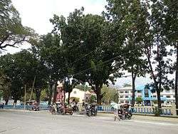 Aringay town center along the National Highway | |||
| |||
 Map of La Union with Aringay highlighted | |||
.svg.png) Aringay Location within the Philippines | |||
| Coordinates: 16°24′N 120°21′E / 16.4°N 120.35°ECoordinates: 16°24′N 120°21′E / 16.4°N 120.35°E | |||
| Country |
| ||
| Region | Ilocos Region (Region I) | ||
| Province | La Union | ||
| District | 2nd District | ||
| Founded | 1641 | ||
| Barangays | 24 (see Barangays) | ||
| Government [1] | |||
| • Type | Sangguniang Bayan | ||
| • Mayor | Eric O. Sibuma | ||
| • Electorate | 27,783 voters (2016) | ||
| Area [2] | |||
| • Total | 84.54 km2 (32.64 sq mi) | ||
| Population (2015 census)[3] | |||
| • Total | 47,458 | ||
| • Density | 560/km2 (1,500/sq mi) | ||
| Time zone | UTC+8 (PST) | ||
| ZIP code | 2503 | ||
| PSGC | 013302000 | ||
| IDD : area code | +63 (0)72 | ||
| Climate type | Tropical monsoon climate | ||
| Income class | 2nd municipal income class | ||
| Revenue (₱) | 154,311,046.13 (2016) | ||
| Native languages |
Ilocano Pangasinan | ||
| Website |
www | ||


Aringay (Ilokano: Ili ti Aringay) is a second class municipality in the province of La Union, Philippines. According to the 2015 census, it has a population of 47,458 people.[3]
Aringay is 244 kilometres (152 mi) from Metro Manila and 25 kilometres (16 mi) from San Fernando, the provincial capital.
The town experiences the prevailing monsoon climate of Northern Luzon, characterized by a dry season from November to April and a wet season from May to October. Its economy is based primarily on agriculture, producing rice, tobacco and fruit crops as economic staples. A nascent tourism industry is centered on its beach resorts. Its ethnic population is predominantly Ilocano and Christian (Roman Catholic).
Barangays
| Rank | Barangay | Population | Rank | Barangay | Population | |
|---|---|---|---|---|---|---|
| 1 | San Eugenio | 3,682 | 14 | Macabato | 1,235 | |
| 2 | Poblacion | 3,464 | 15 | San Simon West | 1,225 | |
| 3 | San Benito Sur | 3,354 | 16 | Pangao-aoan East | 1,221 | |
| 4 | Dulao | 3,284 | 17 | San Juan West | 1,182 | |
| 5 | Santa Rita West | 3,192 | 18 | Santa Rita East | 1,078 | |
| 6 | Santa Lucia | 2,861 | 19 | San Simon East | 1,051 | |
| 7 | Samara | 2,487 | 20 | San Antonio | 1,024 | |
| 8 | San Benito Norte | 2,428 | 21 | Gallano | 1,014 | |
| 9 | Basca | 2,050 | 22 | San Juan East | 899 | |
| 10 | Santa Cecilia | 1,823 | 23 | Alaska | 891 | |
| 11 | Santo Rosario West | 1,789 | 24 | Pangao-aoan West | 807 | |
| 12 | Manga | 1,465 | Aringay Total | 44,949 | ||
| 13 | Santo Rosario East | 1,443 | ||||
History
Aringay was an ancient village known in pre-colonial times as Alingay or Alinguey. When Spanish colonizers arrived in the late 16th century, they found an enclave of ethnic Pangasinenses actively trading with their Ilocano and Ifugao neighbors and traders from China, Japan and Southeast Asia. The presence of Spanish soldiers, administrators and Augustinian missionaries ushered in the town’s colonial era and its conversion to Roman Catholicism.
Aringay remained a part of Pangasinan province until April 18, 1854, when the Spanish fused the northern towns of that province with the southern towns of Ilocos Sur to create the new province of La Union (hence, "The Union") The municipalities of Caba and Gallano (later placed in the province of Benguet and then abolished in 1900) were later carved out of Aringay’s northern borders.
The 18th and 19th century marked the active expansion of Ilocano territory. Scores of migrants from the Ilocos provinces pushed their way south so that by the end of the 19th century, Aringay was home to mostly Ilocano and Ilocanized Pangasinenses.
Outbreaks of rebellion rocked the town during four centuries of Spanish, American and Japanese colonization. Bloody confrontations ignited by revolutionaries such as Diego Silang and Gabriela Silang during Spanish occupation and by insurgents during the Philippine-American War and the Japanese occupation in World War II marred the bucolic villages of Aringay.
A decisive battle on Aringay River against U.S. forces crippled US forces . By 1901 the province of La Union was freed by American occupation.
Japanese forces attacked Aringay on December 1941 and occupied the town until their brutal withdrawal in 1945-1946, when many Aringayenos massacred the entire battalion of Japanese command in Aringay.
Demographics
| Population census of Aringay | ||
|---|---|---|
| Year | Pop. | ±% p.a. |
| 1903 | 8,572 | — |
| 1918 | 11,247 | +1.83% |
| 1939 | 12,487 | +0.50% |
| 1948 | 13,079 | +0.52% |
| 1960 | 17,572 | +2.49% |
| 1970 | 21,835 | +2.19% |
| 1975 | 25,042 | +2.79% |
| 1980 | 27,524 | +1.91% |
| 1990 | 33,258 | +1.91% |
| 1995 | 36,743 | +1.88% |
| 2000 | 41,422 | +2.60% |
| 2007 | 43,438 | +0.66% |
| 2010 | 44,949 | +1.25% |
| 2015 | 47,458 | +1.04% |
| Source: Philippine Statistics Authority[3] [5] [6] [7] | ||
In the 2015 census, the population of Aringay was 47,458 people,[3] with a density of 560 inhabitants per square kilometre or 1,500 inhabitants per square mile.
Gallery
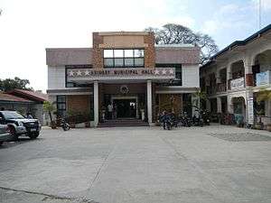 Municipal hall
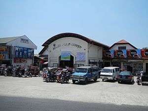 Public market
 Town plaza
 Aringay River
 Street view
Notable people
- Diego Silang
- Gloria Díaz - Miss Philippines 1969, Miss Universe 1969
- Elpidio Quirino
References
- ↑ "Municipality". Quezon City, Philippines: Department of the Interior and Local Government. Retrieved 31 May 2013.
- ↑ "Province: La Union". PSGC Interactive. Quezon City, Philippines: Philippine Statistics Authority. Retrieved 12 November 2016.
- 1 2 3 4 Census of Population (2015). "Region I (Ilocos Region)". Total Population by Province, City, Municipality and Barangay. PSA. Retrieved 20 June 2016.
- ↑ "2010 Census of Population and Housing: Population Counts - Cordillera Administrative Region" (PDF). Philippine Statistics Authority, April 4, 2012. Archived from the original (PDF) on 26 June 2015. Retrieved 16 November 2014.
- ↑ Census of Population and Housing (2010). "Region I (Ilocos Region)". Total Population by Province, City, Municipality and Barangay. NSO. Retrieved 29 June 2016.
- ↑ Censuses of Population (1903–2007). "Region I (Ilocos Region)". Table 1. Population Enumerated in Various Censuses by Province/Highly Urbanized City: 1903 to 2007. NSO.
- ↑ "Province of La Union". Municipality Population Data. Local Water Utilities Administration Research Division. Retrieved 17 December 2016.
External links
| Wikimedia Commons has media related to Aringay. |
- Philippine Standard Geographic Code
- Philippine Census Information
- Local Governance Performance Management System
Places adjacent to Aringay | ||||||||||
|---|---|---|---|---|---|---|---|---|---|---|
| ||||||||||