Gjemnes
| Gjemnes kommune | |||
|---|---|---|---|
| Municipality | |||
 View of Torvikbukt | |||
| |||
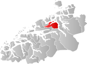 Gjemnes within Møre og Romsdal | |||
| Coordinates: 62°54′59″N 07°55′09″E / 62.91639°N 7.91917°ECoordinates: 62°54′59″N 07°55′09″E / 62.91639°N 7.91917°E | |||
| Country | Norway | ||
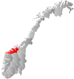
| County | Møre og Romsdal | ||
| District | Nordmøre | ||
| Administrative centre | Batnfjordsøra | ||
| Government | |||
| • Mayor (2015) | Knut Sjømæling (Sp) | ||
| Area | |||
| • Total | 381.63 km2 (147.35 sq mi) | ||
| • Land | 371.07 km2 (143.27 sq mi) | ||
| • Water | 10.56 km2 (4.08 sq mi) | ||
| Area rank | #246 in Norway | ||
| Population (2017) | |||
| • Total | 2,611 | ||
| • Rank | #287 in Norway | ||
| • Density | 7.0/km2 (18/sq mi) | ||
| • Change (10 years) | -1.4% | ||
| Demonym(s) | Gjemnesing[1] | ||
| Time zone | UTC+01:00 (CET) | ||
| • Summer (DST) | UTC+02:00 (CEST) | ||
| ISO 3166 code | NO-1557 | ||
| Official language form | Neutral | ||
| Website |
www | ||
Gjemnes is a municipality in Møre og Romsdal county, Norway on the Romsdal peninsula. It is part of the Nordmøre region. The administrative centre is the village of Batnfjordsøra, which lies along the Batnfjorden and it is a former steamship landing place. Other villages in Gjemnes include Torvikbukt, Flemma, Angvika, Gjemnes, Øre, and Osmarka.
The 382-square-kilometre (147 sq mi) municipality is the 246th largest by area out of the 422 municipalities in Norway. Gjemnes is the 287th most populous municipality in Norway with a population of 2,611. The municipality's population density is 7 inhabitants per square kilometre (18/sq mi) and its population has decreased by 1.4% over the last decade.[2]
General information
The municipality of Gjemnes was established on 1 September 1893 when parts of the municipalities of Kvernes, Øre, and Frei were merged. The initial population of the municipality was 934. On 1 January 1965, Øre Municipality (population: 1,565) and all of Tingvoll Municipality west of the Tingvollfjorden (population: 778) were merged with Gjemnes (population: 697) to form a new, larger municipality of Gjemnes.[3]
Name
The municipality is named after the old Gjemnes farm (Old Norse: *Gímnes), since Gjemnes Church was built there in 1893. The meaning of the first element is probably an old river name (*Gíma), the last element is nes which means "headland".[4]
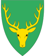
Coat-of-arms
The coat-of-arms is from modern times. They were granted on 4 November 1983. The arms show the head of a Red Deer on a green background. The green symbolizes the agricultural history of the community. The deer antlers have twelve points on it representing the twelve districts of Gjemnes.[5]
Churches
The Church of Norway has two parishes (sokn) within the municipality of Gjemnes. It is part of the Indre Nordmøre deanery in the Diocese of Møre.
| Parish (Sokn) | Church Name | Location of the Church | Year Built |
|---|---|---|---|
| Gjemnes | Gjemnes Church | Gjemnes | 1893 |
| Øre | Øre Church | Øre | 1865 |
| Osmarka Chapel | Heggem | 1910 |
Geography

The municipality lies along the Kvernesfjorden, Batnfjorden, Freifjorden, and Tingvollfjorden. The mountain Reinsfjellet (highest in the municipality) lies near Torvikbukt. The municipality also includes the island of Bergsøya which is located at the junction of the fjords near the village of Gjemnes.
Gjemnes is surrounded by Kristiansund Municipality and Averøy Municipality to the north; Eide, Fræna, and Molde municipalities to the west; Nesset Municipality to the south; and Tingvoll Municipality to the east.
Government
All municipalities in Norway, including Gjemnes, are responsible for primary education (through 10th grade), outpatient health services, senior citizen services, unemployment and other social services, zoning, economic development, and municipal roads. The municipality is governed by a municipal council of elected representatives, which in turn elect a mayor.
Municipal council
The municipal council (Kommunestyre) of Gjemnes is made up of 17 representatives that are elected to four year terms. Currently, the party breakdown is as follows:[6]
| Party Name | Name in Norwegian | Number of representatives | |
|---|---|---|---|
| Labour Party | Arbeiderpartiet | 4 | |
| Progress Party | Fremskrittspartiet | 2 | |
| Conservative Party | Høyre | 3 | |
| Christian Democratic Party | Kristelig Folkeparti | 1 | |
| Centre Party | Senterpartiet | 5 | |
| Socialist Left Party | Sosialistisk Venstreparti | 1 | |
| Liberal Party | Venstre | 1 | |
| Total number of members: | 17 | ||
Transport
European Route E39 runs through the municipality and over the Gjemnessund Bridge and Bergsøysund Bridge connecting Gjemnes to Tingvoll Municipality. The Freifjord Tunnel (part of Norwegian National Road 70) runs from Bergsøya to the nearby island of Frei (and ultimately Kristiansund).
References
- ↑ "Navn på steder og personer: Innbyggjarnamn" (in Norwegian). Språkrådet. Retrieved 2015-12-01.
- ↑ Statistisk sentralbyrå (2017). "Table: 06913: Population 1 January and population changes during the calendar year (M)" (in Norwegian). Retrieved 2017-10-14.
- ↑ Jukvam, Dag (1999). "Historisk oversikt over endringer i kommune- og fylkesinndelingen" (PDF) (in Norwegian). Statistisk sentralbyrå.
- ↑ Rygh, Oluf (1908). Norske gaardnavne: Romsdals amt (in Norwegian) (13 ed.). Kristiania, Norge: W. C. Fabritius & sønners bogtrikkeri. p. 354.
- ↑ "Familiens våpen" (in Norwegian). Retrieved 2008-10-18.
- ↑ "Table: 04813: Members of the local councils, by party/electoral list at the Municipal Council election (M)" (in Norwegian). Statistics Norway. 2015.
External links
- Municipal fact sheet from Statistics Norway (in Norwegian)
- Official website (in Norwegian)

