Hitra Tunnel
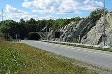 View of the north entrance to the tunnel | |
| Overview | |
|---|---|
| Location | Trøndelag, Norway |
| Coordinates | 63°30′04″N 9°05′51″E / 63.5010°N 9.0974°ECoordinates: 63°30′04″N 9°05′51″E / 63.5010°N 9.0974°E |
| Status | In use |
| Route | 714 |
| Start | Hemnskjela |
| End | Jøsnøya |
| Operation | |
| Opened | 8 December 1994 |
| Operator | Statens vegvesen |
| Traffic | Automotive |
| Technical | |
| Length | 5,645 metres (18,520 ft) |
| No. of lanes | 3 |
| Lowest elevation | −264 metres (−866 ft) |
| Grade | 10% |
The Hitra Tunnel (Norwegian: Hitratunnelen) is an undersea tunnel connecting the island municipality of Hitra to the mainland municipality of Snillfjord in Trøndelag county, Norway. The tunnel is 5,645 metres (18,520 ft) long and reaches a depth of 264 metres (866 ft) below sea level, making it the deepest tunnel in the world when it was built.[1][2]
The tunnel begins in the municipality of Hitra on the island of Jøsnøya, just south of the village of Sandstad. The tunnel then runs under the Trondheimsleia to the island of Hemnskjela in Snillfjord municipality. There is a small bridge connecting Hemnskjela to the mainland. The tunnel was built as part of a large project called "Fastlandsforbindelsen Hitra–Frøya". The project also included the construction of the Frøya Tunnel and the construction of a road and bridge network connecting the islands of Fjellværøy and Frøya.
The tunnel has three lanes. Nearly 2,500 cars pass through it every day. Electronics and pumps handle over 38,000 litres (8,400 imp gal; 10,000 US gal) of water per hour.[3]
Media gallery
 View of the south end of the tunnel
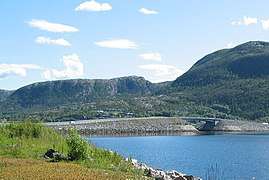 View of the bridge connecting Hemnskjela to the mainland
References
- ↑ Merzagora, Eugenio A.; Lotsberg, Gunnar (eds.). "Road Tunnels in Norway > 3 000 m". Road Tunnels in Norway. Retrieved 2010-12-28.
- ↑ Store norske leksikon. "Hitratunnelen" (in Norwegian). Retrieved 2010-12-28.
- ↑ "Hitratunnelen". Hitra·Frøya (36(46)). 2011-06-21.