Gannett Peak
| Gannett Peak | |
|---|---|
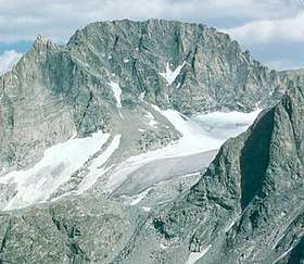 West face of Gannett Peak, Bridger Wilderness, Bridger-Teton National Forest | |
| Highest point | |
| Elevation | 13,810 ft (4,210 m) [1][2] |
| Prominence | 7,076 ft (2,157 m) [1] |
| Isolation | 290 mi (470 km) [1] |
| Parent peak | Longs Peak[3] |
| Listing | |
| Coordinates | 43°11′03″N 109°39′15″W / 43.184202022°N 109.654233614°WCoordinates: 43°11′03″N 109°39′15″W / 43.184202022°N 109.654233614°W [2] |
| Geography | |
 Gannett Peak Wyoming | |
| Location | Fremont and Sublette Counties, Wyoming, United States |
| Parent range | Wind River Range |
| Topo map | USGS Gannett Peak |
| Climbing | |
| First ascent | 1922 by A. Tate and F. Stahlnaker |
| Easiest route | rock/ice climb |
Gannett Peak[4] is the highest mountain peak in the U.S. state of Wyoming at 13,810 feet (4,210 m) above sea level. It straddles the boundary between Fremont and Sublette counties along the Continental Divide in the Wind River Range. It is the highest ground for 290 miles.
Overview
Geographically, Gannett Peak is the apex of the entire Central Rockies, the largely continuous chain of mountains occupying the states of Wyoming, Idaho and Montana. Named in 1906 for American geographer Henry Gannett,[5] the peak is also the high point of the Wind River Range. The mountain slopes are located in both Bridger-Teton National Forest and Shoshone National Forest.
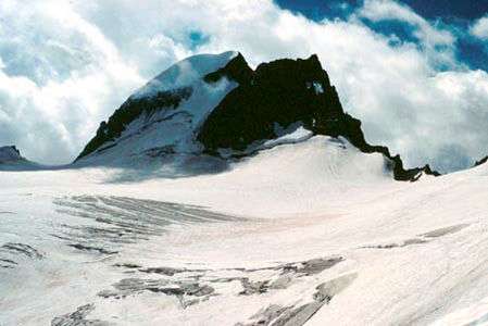
Gannett is the highest peak within what is better known as the Greater Yellowstone Ecosystem and is the highest peak in the Rocky Mountains outside of Colorado. The 896-acre (3.63 km2) Gannett Glacier, which is likely the largest single glacier in the American portion of the Rocky Mountains, extends across the northern slopes of the mountain. Minor Glacier is situated in the western cirque of the peak while Dinwoody and Gooseneck Glaciers can be found on the southeast side of the mountain.
Gannett Peak is in the heart of a remote and rugged wilderness, and climbing is usually attempted in a four- to six-day round-trip. It is often considered by mountaineers to be one of the most difficult U.S. state high points to reach, after Denali and possibly Granite Peak.
In October 2010, a private plane crash in the vicinity of the mountain triggered an extensive search-and-rescue operation.[6] The plane was located in early November, with no survivors.[7]
See also

- List of mountain peaks of the United States
References
- 1 2 3 "Gannett Peak, Wyoming". Peakbagger.com. Retrieved May 8, 2018.
- 1 2 "Gannett Peak Cairn". NGS data sheet. U.S. National Geodetic Survey. Retrieved 2008-12-05.
- ↑ "Gannett Peak". ListsOfJohn.com. Retrieved 2008-12-05.
- ↑ U.S. Geological Survey Geographic Names Information System: Gannett Peak
- ↑ Penry, Jerry (27 October 2007). "The Father of Government Mapmaking: Henry Gannett". American Surveyor. Retrieved 2008-09-28.
- ↑ startribune.com
- ↑ startribune.com Archived 13 October 2012 at the Wayback Machine.
External links
| Wikimedia Commons has media related to Gannett Peak. |
- "A photo journal of a trip up Gannett Peak". HikingInTheRockies.com.
- "Gannett Peak". The Mountain Man Community. Retrieved 2008-12-05.
- "Gannett Peak". Topographic map. TopoQuest. Retrieved 2008-12-05.